|
|
- MCZ redirects here. It is also the usual abbreviation for the Harvard University Museum of Comparative Zoology.
| Martin County Airport |
| IATA: none – ICAO: KMCZ – FAA LID: MCZ |
| Summary |
| Airport type |
Public |
| Operator |
Martin County |
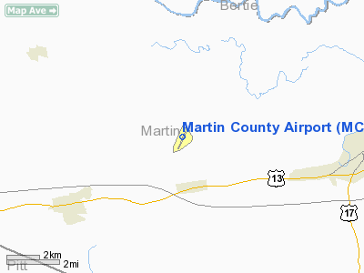
| Location |
Williamston, North Carolina |
| Elevation AMSL |
76 ft / 23.2 m |
| Coordinates |
35°51′44″N 077°10′42″W / 35.86222°N 77.17833°W / 35.86222; -77.17833Coordinates: 35°51′44″N 077°10′42″W / 35.86222°N 77.17833°W / 35.86222; -77.17833 |
| Runways |
| Direction |
Length |
Surface |
| ft |
m |
| 3/21 |
5,000 |
1,524 |
Asphalt |
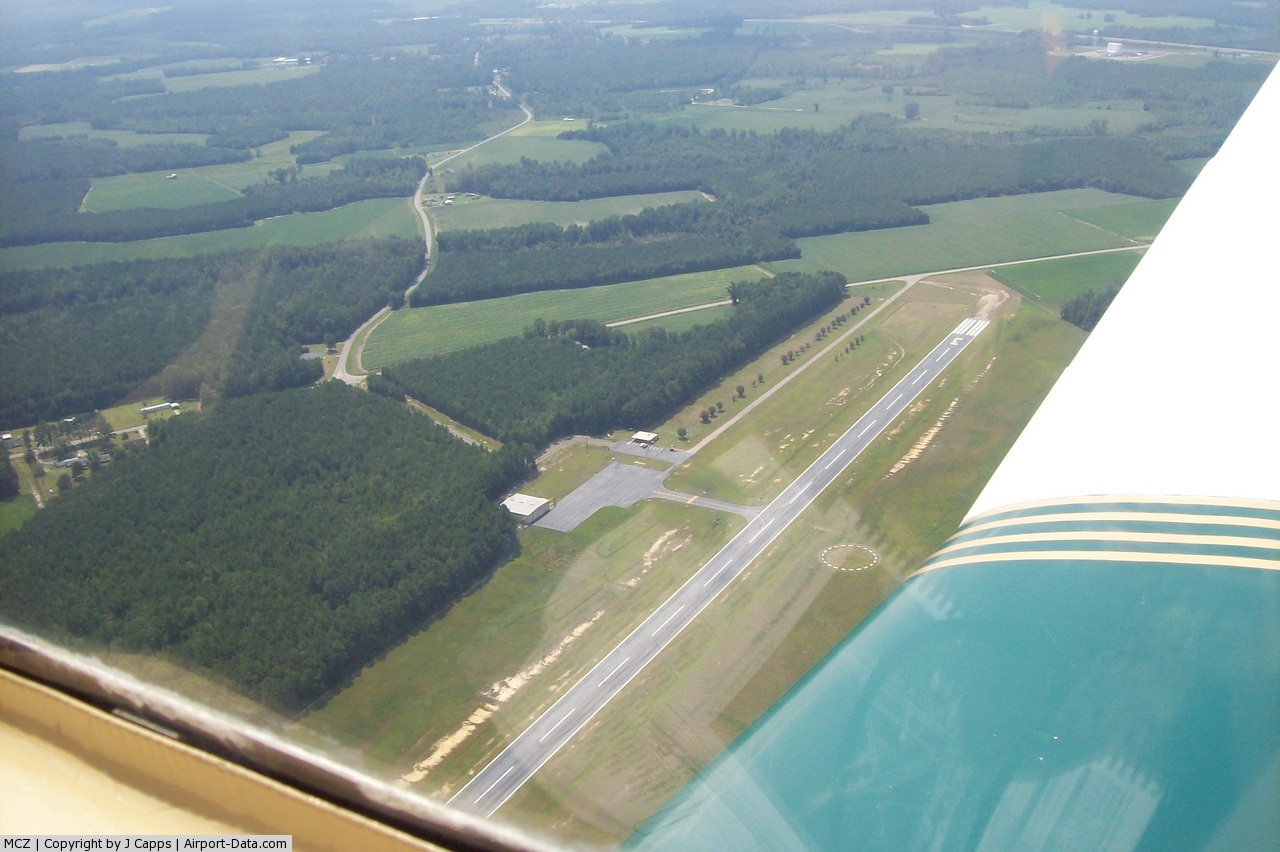
Martin County Airport (ICAO: KMCZ, FAA LID: MCZ) is a public airport located six miles (10 km) west of the central business district (CBD) of Williamston, a town in Martin County, North Carolina, USA. This general aviation airport covers 82 acres (330,000 m) and has one runway.
Although most U.S. airports use the same three-letter location identifier for the FAA and IATA, Martin County Airport is assigned MCZ by the FAA but has no designation from the IATA (which assigned MCZ to Maceió, Alagoas, Brazil). The airport's ICAO identifier is KMCZ.
The above content comes from Wikipedia and is published under free licenses – click here to read more.
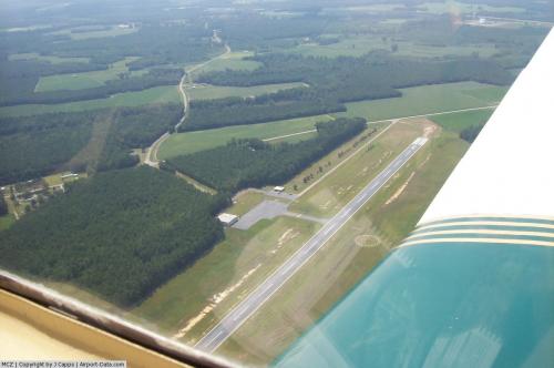 |
(Click on the photo to enlarge) |
Location & QuickFacts
| FAA Information Effective: | 2008-09-25 |
| Airport Identifier: | MCZ |
| Airport Status: | Operational |
| Longitude/Latitude: | 077-10-41.5300W/35-51-43.8950N
-77.178203/35.862193 (Estimated) |
| Elevation: | 76 ft / 23.16 m (Surveyed) |
| Land: | 82 acres |
| From nearest city: | 6 nautical miles W of Williamston, NC |
| Location: | Martin County, NC |
| Magnetic Variation: | 09W (1990) |
Owner & Manager
| Ownership: | Publicly owned |
| Owner: | County Of Martin |
| Address: | Martin Co. Courthouse
Williamston, NC 27892 |
| Phone number: | 252-792-1901 |
| Manager: | Bernard Hudgins |
| Address: | 2135 Airport Rd
Williamston, NC 27892 |
| Phone number: | 252-792-1971
OR 252-792-8151. |
Airport Operations and Facilities
| Airport Use: | Open to public |
| Wind indicator: | Yes |
| Segmented Circle: | Yes |
| Control Tower: | No |
| Lighting Schedule: | DUSK-DAWN
ACTIVATE MIRL RY 03/21 - 122.8. |
| Beacon Color: | Clear-Green (lighted land airport) |
| Landing fee charge: | No |
| Sectional chart: | Charlotte |
| Region: | ASO - Southern |
| Boundary ARTCC: | ZDC - Washington |
| Tie-in FSS: | RDU - Raleigh |
| FSS on Airport: | No |
| FSS Toll Free: | 1-800-WX-BRIEF |
| NOTAMs Facility: | RDU (NOTAM-d service avaliable) |
| Federal Agreements: | NGY |
Airport Communications
| CTAF: | 122.800 |
| Unicom: | 122.800 |
Airport Services
| Fuel available: | 100LLA1+
FOR FUEL AFTER HOURS CALL 252-792-8151 OR PAGER 252-792-9420. |
| Bottled Oxygen: | NONE |
| Bulk Oxygen: | NONE |
Runway Information
Runway 03/21
| Dimension: | 5000 x 75 ft / 1524.0 x 22.9 m |
| Surface: | ASPH, Fair Condition |
| Weight Limit: | Single wheel: 21000 lbs. |
| Edge Lights: | Medium |
| |
Runway 03 |
Runway 21 |
| Longitude: | 077-10-53.7640W | 077-10-29.3040W |
| Latitude: | 35-51-21.2530N | 35-52-06.5330N |
| Elevation: | 66.00 ft | 76.00 ft |
| Alignment: | 24 | 127 |
| Traffic Pattern: | Left | Left |
| Markings: | Non-precision instrument, Good Condition | Non-precision instrument, Good Condition |
| Crossing Height: | 25.00 ft | 24.00 ft |
| VASI: | 2-box on left side
VASI OTS INDEFLY. | 2-light PAPI on left side
PAPI OTS INDEFLY. |
| Visual Glide Angle: | 3.70° | 3.00° |
| Obstruction: | 15 ft road, 450.0 ft from runway, 260 ft right of centerline, 16:1 slope to clear | 50 ft trees, 1200.0 ft from runway, 20:1 slope to clear |
|
Radio Navigation Aids
| ID |
Type |
Name |
Ch |
Freq |
Var |
Dist |
| PGV | FAN MARKER | Belvoir | | | 06W | 16.7 nm |
| MCZ | NDB | Williamston | | 336.00 | 09W | 0.2 nm |
| AQE | NDB | Alwood | | 230.00 | 09W | 13.3 nm |
| ETC | NDB | Tarboro | | 257.00 | 08W | 18.5 nm |
| PMZ | NDB | Plymouth | | 221.00 | 10W | 20.5 nm |
| RNW | NDB | Chocowinity | | 388.00 | 07W | 21.5 nm |
| ASJ | NDB | Ahoskie | | 415.00 | 10W | 26.3 nm |
| EDE | NDB | Edenton | | 265.00 | 10W | 31.3 nm |
| RW | NDB | Jambe | | 235.00 | 09W | 38.7 nm |
| JYN | NDB | Wayne | | 208.00 | 08W | 40.6 nm |
| RZZ | NDB | Rapids | | 407.00 | 08W | 43.3 nm |
| ELQ | NDB | Emporia | | 261.00 | 10W | 47.0 nm |
| LLW | NDB | Woodville | | 254.00 | 10W | 49.1 nm |
| EWN | VOR/DME | New Bern | 083X | 113.60 | 08W | 47.9 nm |
| TYI | VORTAC | Tar River | 125X | 117.80 | 05W | 26.5 nm |
| CVI | VORTAC | Cofield | 093X | 114.60 | 09W | 34.1 nm |
| ISO | VORTAC | Kinston | 033X | 109.60 | 05W | 34.9 nm |
Remarks
- DEER ON AND INVOF ARPT.
- RY SAFETY AREA HAS DEPRESSIONS AND SFC VARIATIONS.
Images and information placed above are from
http://www.airport-data.com/airport/MCZ/
We thank them for the data!
| General Info
|
| Country |
United States
|
| State |
NORTH CAROLINA
|
| FAA ID |
MCZ
|
| Latitude |
35-51-43.895N
|
| Longitude |
077-10-41.530W
|
| Elevation |
76 feet
|
| Near City |
WILLIAMSTON
|
We don't guarantee the information is fresh and accurate. The data may
be wrong or outdated.
For more up-to-date information please refer to other sources.
|
|