 |
|
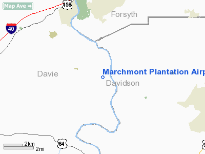
Marchmont Plantation Airpark Airport |
Location & QuickFacts
| FAA Information Effective: | 2008-09-25 |
| Airport Identifier: | 6NC8 |
| Airport Status: | Operational |
| Longitude/Latitude: | 080-23-04.1950W/35-56-17.4930N
-80.384499/35.938192 (Estimated) |
| Elevation: | 730 ft / 222.50 m (Estimated) |
| Land: | 3 acres |
| From nearest city: | 1 nautical miles E of Advance, NC |
| Location: | Davie County, NC |
| Magnetic Variation: | 06W (1985) |
Owner & Manager
| Ownership: | Privately owned |
| Owner: | Dr. J. W. Eubanks |
| Address: | Po Box 148
Advance, NC 27006 |
| Phone number: | 336-998-2600 |
| Manager: | Dr. J. W. Eubanks |
| Address: | Po Box 148
Advance, NC 27006 |
| Phone number: | 336-998-2600 |
Airport Operations and Facilities
| Airport Use: | Private |
| Wind indicator: | Yes |
| Segmented Circle: | No |
| Control Tower: | No |
| Sectional chart: | Charlotte |
| Region: | ASO - Southern |
| Boundary ARTCC: | ZTL - Atlanta |
| Tie-in FSS: | RDU - Raleigh |
| FSS Toll Free: | 1-800-WX-BRIEF |
Runway Information
Runway 06/24
| Dimension: | 2500 x 60 ft / 762.0 x 18.3 m |
| Surface: | TURF, |
| |
Runway 06 |
Runway 24 |
| Traffic Pattern: | Left | Left |
|
Radio Navigation Aids
| ID |
Type |
Name |
Ch |
Freq |
Var |
Dist |
| OQA | FAN MARKER | Rockingham County | | | | 39.8 nm |
| DVZ | NDB | Davie | | 354.00 | 06W | 3.8 nm |
| SEN | NDB | Swearing/dcmsnd | | 260.00 | 06W | 10.4 nm |
| RU | NDB | Rovdy | | 275.00 | 06W | 13.3 nm |
| AZW | NDB | Mount Airy | | 223.00 | 07W | 27.7 nm |
| ZEF | NDB | Zephyr | | 326.00 | 05W | 27.9 nm |
| CQJ | NDB | City Lake | | 266.00 | 08W | 28.6 nm |
| VU | NDB | Aller | | 346.00 | 06W | 30.8 nm |
| VW | NDB | Temky | | 280.00 | 05W | 34.6 nm |
| UKF | NDB | Wilki | | 209.00 | 06W | 36.2 nm |
| HB | NDB | Himun | | 361.00 | 08W | 39.0 nm |
| SIF | NDB | Slammer | | 423.00 | 07W | 40.3 nm |
| IZN | NDB | Lincolnton | | 432.00 | 06W | 41.9 nm |
| UV | NDB | Bales | | 396.00 | 07W | 45.2 nm |
| HK | NDB | Tawba | | 332.00 | 06W | 45.8 nm |
| TOX | NDB | Siler City | | 371.00 | 07W | 46.2 nm |
| BZM | VOR/DME | Barretts Mountain | 045X | 110.80 | 06W | 41.9 nm |
| GSO | VORTAC | Greensboro | 109X | 116.20 | 03W | 20.9 nm |
| LIB | VORTAC | Liberty | 077X | 113.00 | 03W | 38.4 nm |
Remarks
Images and information placed above are from
http://www.airport-data.com/airport/6NC8/
We thank them for the data!
| General Info
|
| Country |
United States
|
| State |
NORTH CAROLINA
|
| FAA ID |
6NC8
|
| Latitude |
35-56-17.493N
|
| Longitude |
080-23-04.195W
|
| Elevation |
730 feet
|
| Near City |
ADVANCE
|
We don't guarantee the information is fresh and accurate. The data may
be wrong or outdated.
For more up-to-date information please refer to other sources.
|
|


