|
|
| Mackall Army Airfield |
 |
| IATA: HFF – ICAO: KHFF – FAA LID: HFF |
| Summary |
| Airport type |
Military |
| Owner |
U.S. Army ATCA-ASO |
| Location |
Richmond / Scotland counties, North Carolina |
| Elevation AMSL |
376 ft / 115 m |
| Coordinates |
35°02′11″N 079°29′51″W / 35.03639°N 79.4975°W / 35.03639; -79.4975 |
| Runways |
| Direction |
Length |
Surface |
| ft |
m |
| 4/22 |
5,001 |
1,524 |
Asphalt |
| 11/29 |
4,740 |
1,445 |
Concrete |
| Source: Federal Aviation Administration |
Camp Mackall is an active U.S. Army training facility located in eastern Richmond County and northern Scotland County, North Carolina, south of the town of Southern Pines. The facility is in close proximity to and is a sub-installation of Fort Bragg (home to the XVIII Airborne Corps, the 82nd Airborne Division and the U.S. Army Special Operations Command Headquarters).
Camp Mackall is the setting of primary training to become a member of U.S. Army Special Forces. Inside the camp is the Resistance Training Laboratory, a mock prisoner-of-war camp in which special force soldiers are trained in resistance techniques for use if captured by enemy combatants. History
On February 8, 1943, General Order Number 6 renamed the facility Camp Mackall in honor of Private John Thomas (Tommy) Mackall. He was born May 17, 1920 in Ohio and grew up in Wellsville, Ohio. He served in the 2nd Battalion, 503rd Parachute Infantry Regiment. During the Allied invasion of North Africa in the airborne segment called Operation Torch, he was mortally wounded in an attack by French Vichy aircraft on his aircraft as the aircraft landed near Oran. Seven paratroopers died at the scene and several were wounded, including Mackall. He was evacuated by air to a British hospital at Gibraltar where he died on November 12, 1942.
Facilities
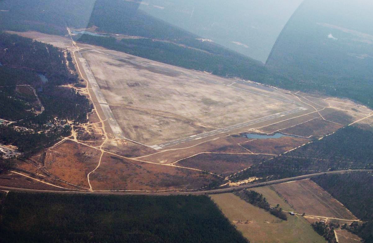
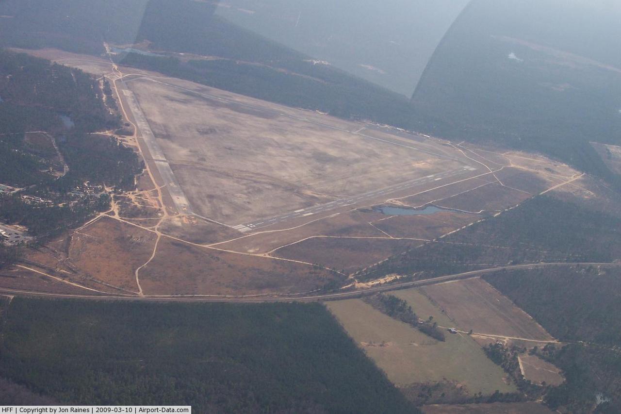
The Mackall Army Airfield at Camp Mackall has two runways: 4/22 is 5,001 by 150 feet (1,524 x 46 m) with an asphalt surface and 11/29 is 4,740 by 150 feet (1,445 x 46 m) with a concrete surface.
The Colonel James "Nick" Rowe Training Compound at Camp Mackall hosts SERE, SFAS, the Q Course and other training courses. It is named for Col. James N. Rowe. The obstacle course at the camp, arguably the hardest obstacle course in the U.S. Army, is named the "Nasty Nick" in honor of Rowe.
The above content comes from Wikipedia and is published under free licenses – click here to read more.

 |
(Click on the photo to enlarge) |
Location & QuickFacts
| FAA Information Effective: | 2008-09-25 |
| Airport Identifier: | HFF |
| Airport Status: | Operational |
| Longitude/Latitude: | 079-29-51.0000W/35-02-11.4000N
-79.497500/35.036500 (Estimated) |
| Elevation: | 376 ft / 114.60 m (Estimated) |
| Land: | 0 acres |
| From nearest city: | 1 nautical miles E of Camp Mackall, NC |
| Location: | Richmond County, NC |
| Magnetic Variation: | 06W (1985) |
Owner & Manager
| Ownership: | Army owned |
| Owner: | Us Army Atca-aso |
| Address: | Cameron Station
Alexandria, VA 22314 |
| Address: |
|
Airport Operations and Facilities
| Airport Use: | Private |
| Segmented Circle: | No |
| Control Tower: | Yes |
| Lighting Schedule: | 0800-0000
HIRL RY 11/29 AND REILS RY 11 & 29 OPER CONT 0800-0000 MON-FRI. |
| Beacon Color: | Split-Clear-Green (lighted military airport) |
| Sectional chart: | Charlotte |
| Region: | ASO - Southern |
| Boundary ARTCC: | ZDC - Washington |
| Tie-in FSS: | HFF - Camp Mackall |
| FSS on Airport: | No |
| FSS Toll Free: | 1-800-WX-BRIEF |
| Alternate FSS: | RDU - Raleigh |
| Alt. FSS Toll Free: | 1-800-WX-BRIEF |
| NOTAMs Facility: | RDU (NOTAM-d service avaliable) |
Airport Services
| Fuel available: | B+
J4 & J8 FUEL AVAIL. |
Runway Information
Runway 04/22
| Dimension: | 5001 x 150 ft / 1524.3 x 45.7 m |
| Surface: | ASPH, |
| |
Runway 04 |
Runway 22 |
| Traffic Pattern: | Left | Left |
| Displaced threshold: | 500.00 ft | 0.00 ft |
|
Runway 11/29
| Dimension: | 4740 x 150 ft / 1444.8 x 45.7 m |
| Surface: | CONC, |
| Edge Lights: | High |
| |
Runway 11 |
Runway 29 |
| Traffic Pattern: | Left | Left |
| Runway End Identifier: | Yes | Yes |
|
Radio Navigation Aids
| ID |
Type |
Name |
Ch |
Freq |
Var |
Dist |
| HFF | NDB | Mackall | | 278.00 | 06W | 0.8 nm |
| RCZ | NDB | Roscoe | | 375.00 | 07W | 14.7 nm |
| ME | NDB | Maxtn | | 257.00 | 08W | 18.4 nm |
| EEJ | NDB | Lee County/dcmsnd | | 428.00 | 07W | 24.3 nm |
| CQW | NDB | Cheraw | | 409.00 | 05W | 25.4 nm |
| BES | NDB | Bennettsville | | 230.00 | 07W | 27.6 nm |
| AFP | NDB | Anson County | | 283.00 | 07W | 28.8 nm |
| POB | NDB | Pope | | 338.00 | 07W | 29.0 nm |
| TT | NDB | Leeco | | 406.00 | 08W | 32.8 nm |
| RSY | NDB | Robeson | | 359.00 | 08W | 33.4 nm |
| FGP | NDB | Fort Bragg | | 393.00 | 07W | 34.2 nm |
| JB | NDB | Jigel | | 384.00 | 08W | 34.4 nm |
| DLC | NDB | Dillon | | 274.00 | 05W | 35.8 nm |
| VU | NDB | Aller | | 346.00 | 06W | 39.4 nm |
| UDG | NDB | Darlington | | 245.00 | 06W | 40.5 nm |
| TOX | NDB | Siler City | | 371.00 | 07W | 43.6 nm |
| CQJ | NDB | City Lake | | 266.00 | 08W | 44.7 nm |
| PYG | NDB | Pageland | | 270.00 | 06W | 45.0 nm |
| HQT | NDB | Harnett | | 417.00 | 08W | 46.9 nm |
| HVS | NDB | Hartsville | | 341.00 | 07W | 48.8 nm |
| POB | TACAN | Pope | 085X | | 07W | 24.6 nm |
| LBT | VOR | Lumberton | | 110.00 | 08W | 33.6 nm |
| FAY | VOR/DME | Fayetteville | 025X | 108.80 | 04W | 30.8 nm |
| CTF | VOR/DME | Chesterfield | 019X | 108.20 | 03W | 44.8 nm |
| SDZ | VORTAC | Sandhills | 055X | 111.80 | 03W | 11.6 nm |
| LIB | VORTAC | Liberty | 077X | 113.00 | 03W | 46.9 nm |
| FLO | VORTAC | Florence | 099X | 115.20 | 03W | 48.9 nm |
Remarks
- HI ALT PARACHUTE ACTIVITY PARTICULARLY IN AM.
- CAUTION: EXTSV MIL ACT VCNTY MACKALL AAF DAY AND NIGHT.
- COPTERS WITH HVY DUTY SKID SHOES WILL NOT TD ON RWY 04/22 OR SET DOWN OR PRK APRONS EXC CONC REFUEL PADS.
- CAUTION: 120' COM ANT LCTD WSW CORNER OF FIRE STN.
- AFLD SUBJ TO CLOSING ON SHORT NTC.
- SEE FLIP AP/1 FLT HAZ SANDHILLS VORTAC.
- RSTD: PPR FOR ALL TRANS ACFT.
- RSTD: FIRST 1000' RWY 11 USABLE FOR R/W OPR ONLY, REMAINDER OF RWY CLSD. FIRST 3500' RWY 29 CLSD.
- RSTD: TWY D LTD TO ACN 32 R/B/X/T.
- RSTD: COPTER WITH HVY DUTY SKID SHOES WILL NOT TD ON RWY 04-22 OR PRK APN, EXC CONCRETE PADS.
- RSTD: RWY 16-34 CLSD UFN.
- FOR NOTAMS ON FAA CIRCUITS CK RDU.
- CAUTION: EXTV MIL ACT VCNTY AFLD, DAY AND NGT. 120' ANT LCTD WSW CORNER FIRE STN. ADVSY: RNG CTL 121.0, 304.6.
- MISC: CTC TWR CHIEF DSN 236-7308/1731 DUR OPR HR, OT DSN 236-7804.
- MISC: NO ENG WILL BE SHUTDOWN ON RWY 04-22 OR TWY H.
- MISC: WX OBSN AVBL. WX FCST AVBL FR SIMMONS AAF VIA DRCT LINE.
- WHEN TWR AND/OR SFC VIS IS BLO 4 SM THE LESSER WILL BE RPRTD AS PVLING.
- WT LTD WAIVER REQ CG 18TH AIRBORNE CORPS FT BRAGG ATTN AFZA-CA-PO WITH NR OF CYCLES EST GROSS WT & DATE/TIME/GROUP.
- FUEL AVBL 1300:2030Z TRANS PPR.
- PPR REQ PHONE C(919)396-6230/V236-6230 DURING OPR HRS; OTHER TIMES V236-7804.
- ALL C130 PPR. PHONE 919-396-6230 OR V236-6230.
Images and information placed above are from
http://www.airport-data.com/airport/HFF/
We thank them for the data!
| General Info
|
| Country |
United States
|
| State |
NORTH CAROLINA
|
| FAA ID |
HFF
|
| Latitude |
35-02-11.565N
|
| Longitude |
079-29-51.148W
|
| Elevation |
376 feet
|
| Near City |
CAMP MACKALL
|
We don't guarantee the information is fresh and accurate. The data may
be wrong or outdated.
For more up-to-date information please refer to other sources.
|
|