 |
|
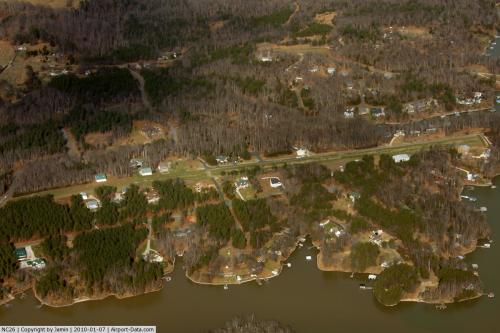 |
(Click on the photo to enlarge) |
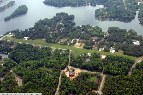 |
(Click on the photo to enlarge) |
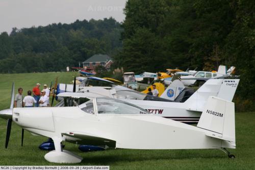 |
(Click on the photo to enlarge) |
Location & QuickFacts
| FAA Information Effective: | 2008-09-25 |
| Airport Identifier: | NC26 |
| Airport Status: | Operational |
| Longitude/Latitude: | 080-58-14.2740W/35-39-39.4840N
-80.970632/35.660968 (Estimated) |
| Elevation: | 864 ft / 263.35 m (Surveyed) |
| Land: | 20 acres |
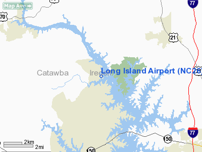
| From nearest city: | 1 nautical miles SE of Long Island, NC |
| Location: | Catawba County, NC |
| Magnetic Variation: | 05W (1985) |
Owner & Manager
| Ownership: | Privately owned |
| Owner: | Steve Griff & Jeff Reynolds |
| Address: | P.o. Box 353
Terrell, NC 28682 |
| Phone number: | 828-478-2642 |
| Manager: | Steve Griff |
| Address: | 1372 Bluebird Lane
Catawba, NC 28609-9284 |
| Phone number: | 704-400-0690 |
Airport Operations and Facilities
| Airport Use: | Private |
| Wind indicator: | No |
| Segmented Circle: | No |
| Control Tower: | No |
| Landing fee charge: | No |
| Sectional chart: | Charlotte |
| Region: | ASO - Southern |
| Boundary ARTCC: | ZTL - Atlanta |
| Tie-in FSS: | RDU - Raleigh |
| FSS on Airport: | No |
| FSS Toll Free: | 1-800-WX-BRIEF |
Airport Services
| Airframe Repair: | NONE |
| Power Plant Repair: | NONE |
Runway Information
Runway 05/23
| Dimension: | 3000 x 100 ft / 914.4 x 30.5 m |
| Surface: | TURF, |
| |
Runway 05 |
Runway 23 |
| Traffic Pattern: | Left | Left |
|
Radio Navigation Aids
| ID |
Type |
Name |
Ch |
Freq |
Var |
Dist |
| MRN | FAN MARKER | Lenoir | | | 03W | 32.9 nm |
| VW | NDB | Temky | | 280.00 | 05W | 8.2 nm |
| IZN | NDB | Lincolnton | | 432.00 | 06W | 9.3 nm |
| HK | NDB | Tawba | | 332.00 | 06W | 18.0 nm |
| RU | NDB | Rovdy | | 275.00 | 06W | 23.9 nm |
| UKF | NDB | Wilki | | 209.00 | 06W | 27.9 nm |
| DVZ | NDB | Davie | | 354.00 | 06W | 29.3 nm |
| GHJ | NDB | Stonia | | 260.00 | 06W | 29.7 nm |
| SEN | NDB | Swearing/dcmsnd | | 260.00 | 06W | 33.6 nm |
| FIQ | NDB | Fiddlers | | 391.00 | 07W | 34.3 nm |
| SLP | NDB | First River | | 417.00 | 06W | 39.3 nm |
| ZEF | NDB | Zephyr | | 326.00 | 05W | 41.0 nm |
| TWL | NDB | Wesley | | 204.00 | 06W | 44.5 nm |
| VU | NDB | Aller | | 346.00 | 06W | 44.7 nm |
| UZ | NDB | Rally | | 227.00 | 05W | 46.7 nm |
| AZW | NDB | Mount Airy | | 223.00 | 07W | 48.1 nm |
| JU | NDB | Ashee | | 410.00 | 07W | 49.5 nm |
| BZM | VOR/DME | Barretts Mountain | 045X | 110.80 | 06W | 18.1 nm |
| CLT | VOR/DME | Charlotte | 097X | 115.00 | 05W | 28.3 nm |
| FML | VORTAC | Fort Mill | 071X | 112.40 | 02W | 40.4 nm |
| HKY | VOT | Hickory Regional | | 110.00 | | 21.1 nm |
| CLT | VOT | Charlotte | | 112.00 | | 26.9 nm |
Remarks
Images and information placed above are from
http://www.airport-data.com/airport/NC26/
We thank them for the data!
| General Info
|
| Country |
United States
|
| State |
NORTH CAROLINA
|
| FAA ID |
NC26
|
| Latitude |
35-39-39.484N
|
| Longitude |
080-58-14.274W
|
| Elevation |
864 feet
|
| Near City |
LONG ISLAND
|
We don't guarantee the information is fresh and accurate. The data may
be wrong or outdated.
For more up-to-date information please refer to other sources.
|
|


