 |
|
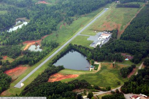 |
(Click on the photo to enlarge) |
Location & QuickFacts
| FAA Information Effective: | 2008-09-25 |
| Airport Identifier: | 6NC1 |
| Airport Status: | Operational |
| Longitude/Latitude: | 081-04-46.2810W/35-35-30.4810N
-81.079523/35.591800 (Estimated) |
| Elevation: | 1030 ft / 313.94 m (Estimated) |
| Land: | 60 acres |
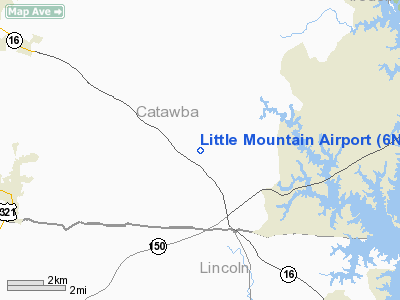
| From nearest city: | 4 nautical miles SE of Denver, NC |
| Location: | Catawba County, NC |
| Magnetic Variation: | 05W (1985) |
Owner & Manager
| Ownership: | Privately owned |
| Owner: | Little Mountain Arpt Assoc |
| Address: | Po Box 488
Denver, NC 28037-0488 |
| Phone number: | 866-584-5423 |
| Manager: | Randy Pharr |
| Address: | 3524 Airport Road
Maiden, NC 28650-9056 |
| Phone number: | 828-464-8471 |
Airport Operations and Facilities
| Airport Use: | Private |
| Wind indicator: | Yes |
| Segmented Circle: | Yes |
| Control Tower: | No |
| Lighting Schedule: | RDO-CTL
ACTVT ROTG BCN AND LIRL RY 03/21 - 130.55. |
| Beacon Color: | Clear-Green (lighted land airport) |
| Landing fee charge: | No |
| Sectional chart: | Atlanta |
| Region: | ASO - Southern |
| Traffic Pattern Alt: | 770 ft |
| Boundary ARTCC: | ZTL - Atlanta |
| Tie-in FSS: | RDU - Raleigh |
| FSS on Airport: | No |
| FSS Toll Free: | 1-800-WX-BRIEF |
Airport Services
| Airframe Repair: | NONE |
| Power Plant Repair: | NONE |
Runway Information
Runway 03/21
| Dimension: | 3000 x 40 ft / 914.4 x 12.2 m |
| Surface: | ASPH, Good Condition |
| Weight Limit: | Single wheel: 15000 lbs. |
| Edge Lights: | Low
NON-STD LGTS. |
| |
Runway 03 |
Runway 21 |
| Traffic Pattern: | Left | Left |
| Runway End Identifier: | No | No |
| Touchdown Lights: | No | No |
| Obstruction: | 30 ft trees, 200.0 ft from runway
TREE 30' RIGHT OF CNTRLN 200' FROM THR.
TREES 85' RIGHT OF CNTRLN; 100' FROM THR. | 19 ft trees, 350.0 ft from runway, 20 ft left of centerline, 26:1 slope to clear
+50' HILL 150' LEFT OF CNTRLN AT THR. |
|
Radio Navigation Aids
| ID |
Type |
Name |
Ch |
Freq |
Var |
Dist |
| MRN | FAN MARKER | Lenoir | | | 03W | 29.3 nm |
| IZN | NDB | Lincolnton | | 432.00 | 06W | 3.3 nm |
| VW | NDB | Temky | | 280.00 | 05W | 11.0 nm |
| HK | NDB | Tawba | | 332.00 | 06W | 16.1 nm |
| GHJ | NDB | Stonia | | 260.00 | 06W | 24.4 nm |
| FIQ | NDB | Fiddlers | | 391.00 | 07W | 29.8 nm |
| RU | NDB | Rovdy | | 275.00 | 06W | 30.0 nm |
| UKF | NDB | Wilki | | 209.00 | 06W | 31.3 nm |
| SLP | NDB | First River | | 417.00 | 06W | 32.6 nm |
| DVZ | NDB | Davie | | 354.00 | 06W | 36.0 nm |
| SEN | NDB | Swearing/dcmsnd | | 260.00 | 06W | 39.8 nm |
| UZ | NDB | Rally | | 227.00 | 05W | 42.2 nm |
| TWL | NDB | Wesley | | 204.00 | 06W | 42.6 nm |
| RFE | NDB | Rutherford | | 344.00 | 05W | 45.2 nm |
| ZEF | NDB | Zephyr | | 326.00 | 05W | 46.7 nm |
| DCM | NDB | Chester | | 220.00 | 06W | 48.8 nm |
| VU | NDB | Aller | | 346.00 | 06W | 49.3 nm |
| BZM | VOR/DME | Barretts Mountain | 045X | 110.80 | 06W | 18.4 nm |
| CLT | VOR/DME | Charlotte | 097X | 115.00 | 05W | 24.9 nm |
| FML | VORTAC | Fort Mill | 071X | 112.40 | 02W | 36.7 nm |
| HKY | VOT | Hickory Regional | | 110.00 | | 17.6 nm |
| CLT | VOT | Charlotte | | 112.00 | | 23.7 nm |
Remarks
- VFR ONLY. OPNL AGREEMENT W/LANEYS ARPT: TRAFFIC AT LITTLE MTN ARPT FLOWN EAST OR RWY CNTRLN EXTNDD & AT LANEYS APRT WEST OF RWY CNTRLN EXTNDD.
Images and information placed above are from
http://www.airport-data.com/airport/6NC1/
We thank them for the data!
| General Info
|
| Country |
United States
|
| State |
NORTH CAROLINA
|
| FAA ID |
6NC1
|
| Latitude |
35-35-30.481N
|
| Longitude |
081-04-46.281W
|
| Elevation |
1030 feet
|
| Near City |
DENVER
|
We don't guarantee the information is fresh and accurate. The data may
be wrong or outdated.
For more up-to-date information please refer to other sources.
|
|


