|
|
Lincolnton-lincoln County Rgnl Airport |
| Lincolnton-Lincoln County Regional Airport |
| IATA: none – ICAO: KIPJ – FAA LID: IPJ |
| Summary |
| Airport type |
Public |
| Owner |
City of Lincolnton & Lincoln County |
| Serves |
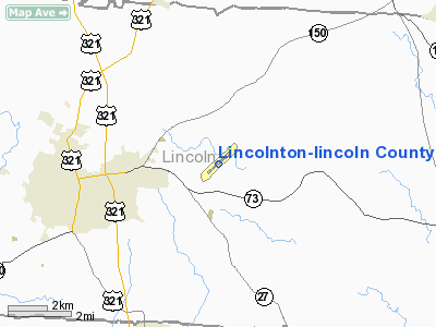
Lincolnton, North Carolina |
| Elevation AMSL |
877 ft / 267 m |
| Coordinates |
35°29′00″N 081°09′40″W / 35.4833333°N 81.16111°W / 35.4833333; -81.16111 |
| Runways |
| Direction |
Length |
Surface |
| ft |
m |
| 5/23 |
5,500 |
1,676 |
Asphalt |
| Statistics (2008) |
| Aircraft operations |
34,100 |
| Based aircraft |
71 |
| Source: Federal Aviation Administration |
Lincolnton-Lincoln County Regional Airport (ICAO: KIPJ, FAA LID: IPJ) is a public use airport located five nautical miles (9 km) east of the central business district of Lincolnton, a city in Lincoln County, North Carolina, United States. It is owned by the City of Lincolnton & Lincoln County. According to the FAA's National Plan of Integrated Airport Systems for 2009–2013, it is a general aviation airport (it had previously been a reliever airport).
Although many U.S. airports use the same three-letter location identifier for the FAA and IATA, this airport is assigned IPJ by the FAA but has no designation from the IATA.
Facilities and aircraft
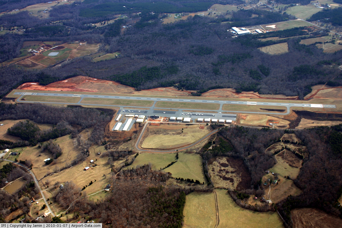
Lincolnton-Lincoln County Regional Airport covers an area of 453 acres (183 ha) at an elevation of 877 feet (267 m) above mean sea level. It has one runway designated 5/23 with an asphalt surface measuring 5,500 by 100 feet (1,676 x 30 m).
For the 12-month period ending June 6, 2008, the airport had 34,100 aircraft operations, an average of 93 per day: 97% general aviation and 3% military. At that time there were 71 aircraft based at this airport: 87% single-engine, 10% multi-engine and 3% helicopter.
The above content comes from Wikipedia and is published under free licenses – click here to read more.
 |
(Click on the photo to enlarge) |
Location & QuickFacts
| FAA Information Effective: | 2008-09-25 |
| Airport Identifier: | IPJ |
| Airport Status: | Operational |
| Longitude/Latitude: | 081-09-40.5000W/35-29-00.0000N
-81.161250/35.483333 (Estimated) |
| Elevation: | 877 ft / 267.31 m (Surveyed) |
| Land: | 453 acres |
| From nearest city: | 5 nautical miles E of Lincolnton, NC |
| Location: | Lincoln County, NC |
| Magnetic Variation: | 06W (1995) |
Owner & Manager
| Ownership: | Publicly owned |
| Owner: | City Of Lincolnton & Lincoln |
| Address: | 716 Airport Drive
Iron Station, NC 28080 |
| Phone number: | 704-736-8488 |
| Manager: | Jeff Lynn |
| Address: | 716 Airport Drive
Iron Station, NC 28080 |
| Phone number: | 704-735-0602 |
Airport Operations and Facilities
| Airport Use: | Open to public |
| Wind indicator: | Yes |
| Segmented Circle: | Yes |
| Control Tower: | No |
| Lighting Schedule: | DUSK-DAWN
MIRL RY 05/23 PRESET LOW INTST; TO INCR INTST & ACTVT REIL RYS 05 & 23 AND PAPI RYS 05 & 23 - CTAF. |
| Beacon Color: | Clear-Green (lighted land airport) |
| Landing fee charge: | No |
| Sectional chart: | Charlotte |
| Region: | ASO - Southern |
| Boundary ARTCC: | ZTL - Atlanta |
| Tie-in FSS: | RDU - Raleigh |
| FSS on Airport: | No |
| FSS Toll Free: | 1-800-WX-BRIEF |
| NOTAMs Facility: | IPJ (NOTAM-d service avaliable) |
| Federal Agreements: | NGY |
Airport Communications
| CTAF: | 123.050 |
| Unicom: | 123.050 |
Airport Services
| Fuel available: | 100LLA1+ |
| Airframe Repair: | MAJOR |
| Power Plant Repair: | MAJOR |
Runway Information
Runway 05/23
| Dimension: | 5500 x 100 ft / 1676.4 x 30.5 m
200 FT STOPWAY SW END. |
| Surface: | ASPH, Good Condition |
| Weight Limit: | Single wheel: 30000 lbs. |
| Edge Lights: | Medium |
| |
Runway 05 |
Runway 23 |
| Longitude: | 081-10-04.9433W | 081-09-16.1486W |
| Latitude: | 35-28-41.4626N | 35-29-18.4740N |
| Elevation: | 877.00 ft | 863.00 ft |
| Alignment: | 47 | 127 |
| ILS Type: | | LOC/DME
|
| Traffic Pattern: | Left | Left |
| Markings: | Non-precision instrument, Fair Condition | Non-precision instrument, Fair Condition |
| Crossing Height: | 44.00 ft | 30.00 ft |
| Displaced threshold: | 303.00 ft | 210.00 ft |
| VASI: | 2-light PAPI on left side | 2-light PAPI on left side |
| Visual Glide Angle: | 3.83° | 3.00° |
| Runway End Identifier: | Yes | Yes |
| Obstruction: | 48 ft trees, 1346.0 ft from runway, 92 ft right of centerline, 23:1 slope to clear
RY 05 APCH SLOPE 43:1 TO DSPLCD THLD. | , 50:1 slope to clear
RY 23 APCH SLOPE 50:1 AT DSPLCD THLD. |
|
Radio Navigation Aids
| ID |
Type |
Name |
Ch |
Freq |
Var |
Dist |
| MRN | FAN MARKER | Lenoir | | | 03W | 29.4 nm |
| IZN | NDB | Lincolnton | | 432.00 | 06W | 4.9 nm |
| GHJ | NDB | Stonia | | 260.00 | 06W | 17.6 nm |
| VW | NDB | Temky | | 280.00 | 05W | 18.1 nm |
| HK | NDB | Tawba | | 332.00 | 06W | 19.5 nm |
| SLP | NDB | First River | | 417.00 | 06W | 25.5 nm |
| FIQ | NDB | Fiddlers | | 391.00 | 07W | 28.4 nm |
| UZ | NDB | Rally | | 227.00 | 05W | 35.9 nm |
| RU | NDB | Rovdy | | 275.00 | 06W | 36.1 nm |
| UKF | NDB | Wilki | | 209.00 | 06W | 38.0 nm |
| TWL | NDB | Wesley | | 204.00 | 06W | 39.0 nm |
| RFE | NDB | Rutherford | | 344.00 | 05W | 39.6 nm |
| DCM | NDB | Chester | | 220.00 | 06W | 41.9 nm |
| DVZ | NDB | Davie | | 354.00 | 06W | 43.0 nm |
| SEN | NDB | Swearing/dcmsnd | | 260.00 | 06W | 45.8 nm |
| LKR | NDB | Lancaster | | 400.00 | 07W | 48.0 nm |
| CLT | VOR/DME | Charlotte | 097X | 115.00 | 05W | 20.4 nm |
| BZM | VOR/DME | Barretts Mountain | 045X | 110.80 | 06W | 23.5 nm |
| FML | VORTAC | Fort Mill | 071X | 112.40 | 02W | 31.4 nm |
| SPA | VORTAC | Spartanburg | 104X | 115.70 | 02W | 46.3 nm |
| HKY | VOT | Hickory Regional | | 110.00 | | 19.1 nm |
| CLT | VOT | Charlotte | | 112.00 | | 19.5 nm |
Remarks
- RY 23 HAS A 90 FT DROP OFF 100 FT FM PAVEMENT.
- GCO AVBL ON FREQ 124.900 THRU CLT CLEARANCE DELIVERY.
- RY 05 APCH RATIO 14:1 TO DSPLCD THLD.
- ARPT PHONE NR 704-735-0602.
- DEER & BIRDS ON & INVOF ARPT.
Images and information placed above are from
http://www.airport-data.com/airport/IPJ/
We thank them for the data!
| General Info
|
| Country |
United States
|
| State |
NORTH CAROLINA
|
| FAA ID |
IPJ
|
| Latitude |
35-28-59.984N
|
| Longitude |
081-09-40.530W
|
| Elevation |
875 feet
|
| Near City |
LINCOLNTON
|
We don't guarantee the information is fresh and accurate. The data may
be wrong or outdated.
For more up-to-date information please refer to other sources.
|
|