 |
|
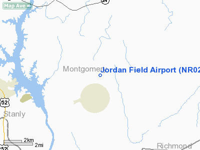
Location & QuickFacts
| FAA Information Effective: | 2008-09-25 |
| Airport Identifier: | NR02 |
| Airport Status: | Operational |
| Longitude/Latitude: | 079-59-44.0000W/35-14-16.0000N
-79.995556/35.237778 (Estimated) |
| Elevation: | 600 ft / 182.88 m (Estimated) |
| Land: | 124 acres |
| From nearest city: | 1 nautical miles NE of Mount Gilead, NC |
| Location: | Montgomery County, NC |
| Magnetic Variation: | () |
Owner & Manager
| Ownership: | Privately owned |
| Owner: | Jordan Lumber Company |
| Address: | 1939 N. C. 109 S.
Mount Gilead, NC 27306 |
| Phone number: | 910-439-6121 |
| Manager: | Kevin Snyder |
| Address: | 1939 N. C.109 S.
Mount Gilead, NC 27306 |
| Phone number: | 910-220-1805 |
Airport Operations and Facilities
| Airport Use: | Private |
| Wind indicator: | Yes |
| Control Tower: | No |
| Sectional chart: | Memphis |
| Region: | ASO - Southern |
| Boundary ARTCC: | ZME - Memphis |
| Tie-in FSS: | JBR - Jonesboro |
| FSS Toll Free: | 1-800-WX-BRIEF |
Runway Information
Runway 04/22
| Dimension: | 4900 x 70 ft / 1493.5 x 21.3 m |
| Surface: | TURF, |
| |
Runway 04 |
Runway 22 |
| Traffic Pattern: | Left | Left |
| Obstruction: | 100 ft trees, 20.0 ft from runway | 100 ft trees, 20.0 ft from runway |
|
Radio Navigation Aids
| ID |
Type |
Name |
Ch |
Freq |
Var |
Dist |
| AFP | NDB | Anson County | | 283.00 | 07W | 13.6 nm |
| VU | NDB | Aller | | 346.00 | 06W | 15.6 nm |
| RCZ | NDB | Roscoe | | 375.00 | 07W | 27.5 nm |
| HFF | NDB | Mackall | | 278.00 | 06W | 28.1 nm |
| CQJ | NDB | City Lake | | 266.00 | 08W | 29.5 nm |
| CQW | NDB | Cheraw | | 409.00 | 05W | 30.5 nm |
| PYG | NDB | Pageland | | 270.00 | 06W | 34.1 nm |
| SEN | NDB | Swearing/dcmsnd | | 260.00 | 06W | 35.8 nm |
| RU | NDB | Rovdy | | 275.00 | 06W | 38.4 nm |
| EEJ | NDB | Lee County/dcmsnd | | 428.00 | 07W | 38.8 nm |
| TWL | NDB | Wesley | | 204.00 | 06W | 38.9 nm |
| BES | NDB | Bennettsville | | 230.00 | 07W | 39.3 nm |
| ME | NDB | Maxtn | | 257.00 | 08W | 40.7 nm |
| TOX | NDB | Siler City | | 371.00 | 07W | 40.9 nm |
| TT | NDB | Leeco | | 406.00 | 08W | 44.7 nm |
| DVZ | NDB | Davie | | 354.00 | 06W | 46.4 nm |
| UDG | NDB | Darlington | | 245.00 | 06W | 48.1 nm |
| HB | NDB | Himun | | 361.00 | 08W | 48.8 nm |
| POB | TACAN | Pope | 085X | | 07W | 48.1 nm |
| CTF | VOR/DME | Chesterfield | 019X | 108.20 | 03W | 37.9 nm |
| CLT | VOR/DME | Charlotte | 097X | 115.00 | 05W | 47.0 nm |
| SDZ | VORTAC | Sandhills | 055X | 111.80 | 03W | 20.1 nm |
| LIB | VORTAC | Liberty | 077X | 113.00 | 03W | 39.3 nm |
| GSO | VORTAC | Greensboro | 109X | 116.20 | 03W | 48.6 nm |
| FML | VORTAC | Fort Mill | 071X | 112.40 | 02W | 49.5 nm |
| CLT | VOT | Charlotte | | 112.00 | | 46.3 nm |
Remarks
- PRVDD VFR OPNS & PVT USE.
Images and information placed above are from
http://www.airport-data.com/airport/NR02/
We thank them for the data!
|
|


