 |
|
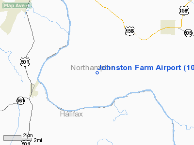
Location & QuickFacts
| FAA Information Effective: | 2008-09-25 |
| Airport Identifier: | 10NC |
| Airport Status: | Operational |
| Longitude/Latitude: | 077-30-34.0000W/36-20-35.0000N
-77.509444/36.343056 (Estimated) |
| Elevation: | 60 ft / 18.29 m (Estimated) |
| Land: | 0 acres |
| From nearest city: | 6 nautical miles SW of Jackson, NC |
| Location: | Northampton County, NC |
| Magnetic Variation: | () |
Owner & Manager
| Ownership: | Privately owned |
| Owner: | William R. Johnston |
| Address: | 1611 Bill Johnston Road
Jackson, NC 27845 |
| Phone number: | 252-583-4151 |
| Manager: | William R. Johnston |
| Address: | 1611 Bill Johnston Road
Jackson, NC 27845 |
| Phone number: | 252-583-4151 |
Airport Operations and Facilities
| Airport Use: | Private |
| Wind indicator: | Yes |
| Control Tower: | No |
| Sectional chart: | Washington |
| Region: | ASO - Southern |
| Boundary ARTCC: | ZDC - Washington |
| Tie-in FSS: | RDU - Raleigh |
| FSS Toll Free: | 1-800-WX-BRIEF |
Runway Information
Runway 13/31
| Dimension: | 2450 x 80 ft / 746.8 x 24.4 m |
| Surface: | TURF, |
| |
Runway 13 |
Runway 31 |
| Traffic Pattern: | Left | Left |
|
Radio Navigation Aids
| ID |
Type |
Name |
Ch |
Freq |
Var |
Dist |
| PGV | FAN MARKER | Belvoir | | | 06W | 42.7 nm |
| RZZ | NDB | Rapids | | 407.00 | 08W | 11.3 nm |
| ASJ | NDB | Ahoskie | | 415.00 | 10W | 16.4 nm |
| ELQ | NDB | Emporia | | 261.00 | 10W | 17.0 nm |
| ETC | NDB | Tarboro | | 257.00 | 08W | 24.6 nm |
| AEA | NDB | Jones | | 373.00 | 09W | 30.9 nm |
| MCZ | NDB | Williamston | | 336.00 | 09W | 33.3 nm |
| MBV | NDB | Mecklenburg/dcmsnd | | 356.00 | 08W | 33.7 nm |
| AQE | NDB | Alwood | | 230.00 | 09W | 38.8 nm |
| RW | NDB | Jambe | | 235.00 | 09W | 41.1 nm |
| RK | NDB | Waley | | 249.00 | 10W | 44.3 nm |
| AKQ | NDB | Wakefield | | 274.00 | 09W | 45.6 nm |
| PTB | NDB | Petersburg | | 284.00 | 08W | 47.4 nm |
| PMZ | NDB | Plymouth | | 221.00 | 10W | 48.4 nm |
| EDE | NDB | Edenton | | 265.00 | 10W | 49.6 nm |
| TYI | VORTAC | Tar River | 125X | 117.80 | 05W | 24.0 nm |
| CVI | VORTAC | Cofield | 093X | 114.60 | 09W | 30.9 nm |
| FKN | VORTAC | Franklin | 043X | 110.60 | 09W | 32.8 nm |
| LVL | VORTAC | Lawrenceville | 076X | 112.90 | 08W | 34.3 nm |
Remarks
- PRVDD VFR OPNS AND PVT USE.
Images and information placed above are from
http://www.airport-data.com/airport/10NC/
We thank them for the data!
| General Info
|
| Country |
United States
|
| State |
NORTH CAROLINA
|
| FAA ID |
10NC
|
| Latitude |
34-48-48.605N
|
| Longitude |
078-01-16.949W
|
| Elevation |
80 feet
|
| Near City |
ROSE HILL
|
We don't guarantee the information is fresh and accurate. The data may
be wrong or outdated.
For more up-to-date information please refer to other sources.
|
|


