 |
|
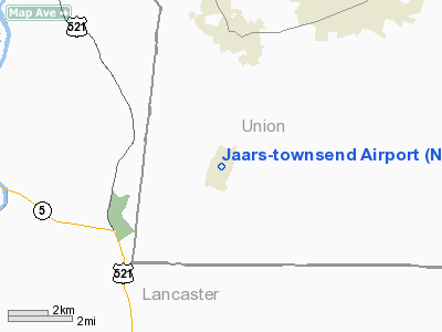
Location & QuickFacts
| FAA Information Effective: | 2008-09-25 |
| Airport Identifier: | N52 |
| Airport Status: | Operational |
| Longitude/Latitude: | 080-44-52.7400W/34-51-49.7400N
-80.747983/34.863817 (Estimated) |
| Elevation: | 602 ft / 183.49 m (Surveyed) |
| Land: | 38 acres |
| From nearest city: | 3 nautical miles S of Waxhaw, NC |
| Location: | Union County, NC |
| Magnetic Variation: | 07W (2000) |
Owner & Manager
| Ownership: | Privately owned |
| Owner: | Jaars Inc. |
| Address: | Box 248
Waxhaw, NC 28173 |
| Phone number: | 704-843-6268 |
| Manager: | Bruce Powell |
| Address: | 7710 Jaars Road
Waxhaw, NC 28173 |
| Phone number: | 704-843-6612
AFT HRS PHONE 704-843-6220. |
Airport Operations and Facilities
| Airport Use: | Open to public |
| Wind indicator: | Yes |
| Segmented Circle: | No |
| Control Tower: | No |
| Lighting Schedule: | DUSK-DAWN
ACTVT ROTG BCN AFT DAWN - CTAF |
| Beacon Color: | Clear-Green (lighted land airport) |
| Landing fee charge: | No |
| Sectional chart: | Charlotte |
| Region: | ASO - Southern |
| Boundary ARTCC: | ZTL - Atlanta |
| Tie-in FSS: | RDU - Raleigh |
| FSS on Airport: | No |
| FSS Toll Free: | 1-800-WX-BRIEF |
| NOTAMs Facility: | RDU (NOTAM-d service avaliable) |
Airport Communications
| CTAF: | 123.000 |
| Unicom: | 123.000 |
Airport Services
| Bottled Oxygen: | NONE |
| Bulk Oxygen: | NONE |
Runway Information
Runway 04/22
| Dimension: | 3309 x 40 ft / 1008.6 x 12.2 m |
| Surface: | ASPH, Good Condition |
| Edge Lights: | Non-standard lighting system
NSTD LIRL; EDGE LIGHTS 30 FT FROM PAVEMENT. |
| |
Runway 04 |
Runway 22 |
| Longitude: | 080-45-04.9600W | 080-44-40.5200W |
| Latitude: | 34-51-36.8600N | 34-52-02.6600N |
| Elevation: | 602.00 ft | 599.00 ft |
| Alignment: | 38 | 127 |
| Traffic Pattern: | Left | Left |
| Markings: | Nonstandard, Good Condition
04/22 MARKINGS NSTD SIZE. | Nonstandard, Good Condition |
| Displaced threshold: | 0.00 ft | 200.00 ft |
| Runway End Identifier: | No | No |
| Centerline Lights: | No | No |
| Touchdown Lights: | No | No |
| Obstruction: | 45 ft trees, 260.0 ft from runway, 138 ft right of centerline, 1:1 slope to clear
+45 FT TREES 0-200 FT FROM THR 120 FT R & L. | 62 ft trees, 365.0 ft from runway, 124 ft right of centerline, 2:1 slope to clear
APCH SLOPE 9:1 TO DSPLCD THLD.
+5 FT FENCE 100 FT FROM THR & 50 FT TREES 120 FT R & L. |
|
Radio Navigation Aids
| ID |
Type |
Name |
Ch |
Freq |
Var |
Dist |
| TWL | NDB | Wesley | | 204.00 | 06W | 5.8 nm |
| LKR | NDB | Lancaster | | 400.00 | 07W | 10.0 nm |
| UZ | NDB | Rally | | 227.00 | 05W | 16.5 nm |
| PYG | NDB | Pageland | | 270.00 | 06W | 21.5 nm |
| DCM | NDB | Chester | | 220.00 | 06W | 22.8 nm |
| GHJ | NDB | Stonia | | 260.00 | 06W | 28.2 nm |
| AFP | NDB | Anson County | | 283.00 | 07W | 34.1 nm |
| CDN | NDB | Camden | | 263.00 | 05W | 36.1 nm |
| FDW | NDB | Winnsboro | | 414.00 | 05W | 37.6 nm |
| HVS | NDB | Hartsville | | 341.00 | 07W | 41.5 nm |
| IZN | NDB | Lincolnton | | 432.00 | 06W | 43.8 nm |
| CQW | NDB | Cheraw | | 409.00 | 05W | 44.2 nm |
| UOT | NDB | Union County | | 326.00 | 04W | 45.5 nm |
| SLP | NDB | First River | | 417.00 | 06W | 47.9 nm |
| UDG | NDB | Darlington | | 245.00 | 06W | 49.5 nm |
| VU | NDB | Aller | | 346.00 | 06W | 49.9 nm |
| CLT | VOR/DME | Charlotte | 097X | 115.00 | 05W | 22.0 nm |
| CTF | VOR/DME | Chesterfield | 019X | 108.20 | 03W | 26.6 nm |
| FML | VORTAC | Fort Mill | 071X | 112.40 | 02W | 12.7 nm |
| CLT | VOT | Charlotte | | 112.00 | | 23.1 nm |
Remarks
- RY 4 HAS 5 FT DROP-OFF 150 FT FROM THR 0 BOTH.
- DEER ON AND INVOF ARPT.
- TRAINING ACFT FREQUENTLY OPER AT NSTD ALTITUDES & NSTD PATTERNS.
- ULTRALIGHT ACTIVITY ON & INVOF ARPT.
- RY 04/22 HAS 20 FT DOWN SLOPE BTN ENDS.
- SFC VARIATIONS IN RY SURFACE AREA.
Images and information placed above are from
http://www.airport-data.com/airport/N52/
We thank them for the data!
| General Info
|
| Country |
United States
|
| State |
NORTH CAROLINA
|
| FAA ID |
N52
|
| Latitude |
34-51-49.736N
|
| Longitude |
080-44-52.743W
|
| Elevation |
602 feet
|
| Near City |
WAXHAW
|
We don't guarantee the information is fresh and accurate. The data may
be wrong or outdated.
For more up-to-date information please refer to other sources.
|
|


