 |
|
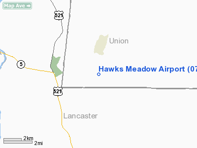
Location & QuickFacts
| FAA Information Effective: | 2008-09-25 |
| Airport Identifier: | 07NC |
| Airport Status: | Operational |
| Longitude/Latitude: | 080-45-04.2420W/34-49-59.5350N
-80.751178/34.833204 (Estimated) |
| Elevation: | 625 ft / 190.50 m (Estimated) |
| Land: | 20 acres |
| From nearest city: | 8 nautical miles S of Waxhaw, NC |
| Location: | Union County, NC |
| Magnetic Variation: | 05W (1990) |
Owner & Manager
| Ownership: | Privately owned |
| Owner: | Wallace L. Overton |
| Address: | Po Box 31305
Charlotte, NC 28231 |
| Phone number: | 704-843-1085 |
| Manager: | Wallace L. Overton |
| Address: | 8504 Walkup Road
Waxhaw, NC 28173 |
| Phone number: | 704-844-9300 |
Airport Operations and Facilities
| Airport Use: | Private |
| Wind indicator: | Yes |
| Segmented Circle: | No |
| Control Tower: | No |
| Sectional chart: | Charlotte |
| Region: | ASO - Southern |
| Boundary ARTCC: | ZTL - Atlanta |
| Tie-in FSS: | RDU - Raleigh |
| FSS Toll Free: | 1-800-WX-BRIEF |
Runway Information
Runway 08/26
| Dimension: | 2000 x 50 ft / 609.6 x 15.2 m |
| Surface: | TURF, |
| |
Runway 08 |
Runway 26 |
| Traffic Pattern: | Left | Left |
| Obstruction: | 20 ft trees, 120.0 ft from runway | 28 ft plines, 0.0 ft from runway |
|
Radio Navigation Aids
| ID |
Type |
Name |
Ch |
Freq |
Var |
Dist |
| TWL | NDB | Wesley | | 204.00 | 06W | 7.5 nm |
| LKR | NDB | Lancaster | | 400.00 | 07W | 8.4 nm |
| UZ | NDB | Rally | | 227.00 | 05W | 16.6 nm |
| PYG | NDB | Pageland | | 270.00 | 06W | 21.1 nm |
| DCM | NDB | Chester | | 220.00 | 06W | 22.4 nm |
| GHJ | NDB | Stonia | | 260.00 | 06W | 29.4 nm |
| CDN | NDB | Camden | | 263.00 | 05W | 34.3 nm |
| AFP | NDB | Anson County | | 283.00 | 07W | 34.9 nm |
| FDW | NDB | Winnsboro | | 414.00 | 05W | 36.0 nm |
| HVS | NDB | Hartsville | | 341.00 | 07W | 40.4 nm |
| CQW | NDB | Cheraw | | 409.00 | 05W | 44.1 nm |
| UOT | NDB | Union County | | 326.00 | 04W | 44.9 nm |
| IZN | NDB | Lincolnton | | 432.00 | 06W | 45.4 nm |
| UDG | NDB | Darlington | | 245.00 | 06W | 48.7 nm |
| SLP | NDB | First River | | 417.00 | 06W | 48.7 nm |
| CLT | VOR/DME | Charlotte | 097X | 115.00 | 05W | 23.6 nm |
| CTF | VOR/DME | Chesterfield | 019X | 108.20 | 03W | 26.0 nm |
| FML | VORTAC | Fort Mill | 071X | 112.40 | 02W | 13.7 nm |
| CLT | VOT | Charlotte | | 112.00 | | 24.7 nm |
Remarks
- PRVDD VFR/PERSONAL USE & TFC PATTERN TO BOTH RYS IS FLOWN TO THE S OF THE ARPT.
Images and information placed above are from
http://www.airport-data.com/airport/07NC/
We thank them for the data!
| General Info
|
| Country |
United States
|
| State |
NORTH CAROLINA
|
| FAA ID |
07NC
|
| Latitude |
34-49-59.535N
|
| Longitude |
080-45-04.242W
|
| Elevation |
625 feet
|
| Near City |
WAXHAW
|
We don't guarantee the information is fresh and accurate. The data may
be wrong or outdated.
For more up-to-date information please refer to other sources.
|
|


