 |
|
Halifax Rgnl Medical Center Heliport |
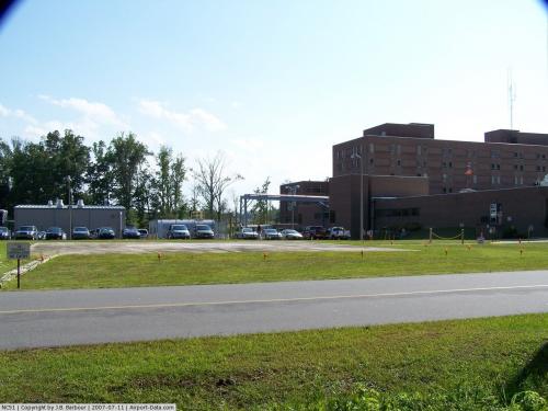 |
(Click on the photo to enlarge) |
Location & QuickFacts
| FAA Information Effective: | 2008-09-25 |
| Airport Identifier: | NC51 |
| Airport Status: | Operational |
| Longitude/Latitude: | 077-38-45.9240W/36-26-12.5430N
-77.646090/36.436818 (Estimated) |
| Elevation: | 169 ft / 51.51 m (Estimated) |
| Land: | 0 acres |
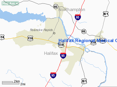
| From nearest city: | 0 nautical miles N of Roanoke Rapids, NC |
| Location: | Halifax County, NC |
| Magnetic Variation: | 08W (1985) |
Owner & Manager
| Ownership: | Publicly owned |
| Owner: | Halifax Regional Medical Center |
| Address: | Po Box 1089
Roanoke Rapids, NC 27870-2089 |
| Phone number: | 252-535-8011 |
| Manager: | Halifax Rgnl Medical Center |
| Address: | 250 Smith Church Road
Roanoke Rapids, NC 27870-4914 |
| Phone number: | 252-535-8011 |
Airport Operations and Facilities
| Airport Use: | Private
MEDICAL. |
| Wind indicator: | Yes |
| Segmented Circle: | No |
| Control Tower: | No |
| Lighting Schedule: | PHONE REQ
FOR PERIMETER LGTS CALL 919-535-8011. |
| Sectional chart: | Charlotte |
| Region: | ASO - Southern |
| Boundary ARTCC: | ZDC - Washington |
| Tie-in FSS: | RDU - Raleigh |
| FSS Toll Free: | 1-800-WX-BRIEF |
Runway Information
Helipad H1
| Dimension: | 90 x 90 ft / 27.4 x 27.4 m |
| Surface: | CONC, |
| |
Runway H1 |
Runway |
| Traffic Pattern: | Left | Left |
|
Radio Navigation Aids
| ID |
Type |
Name |
Ch |
Freq |
Var |
Dist |
| PGV | FAN MARKER | Belvoir | | | 06W | 49.6 nm |
| RZZ | NDB | Rapids | | 407.00 | 08W | 3.0 nm |
| ELQ | NDB | Emporia | | 261.00 | 10W | 15.2 nm |
| AEA | NDB | Jones | | 373.00 | 09W | 22.4 nm |
| ASJ | NDB | Ahoskie | | 415.00 | 10W | 24.2 nm |
| MBV | NDB | Mecklenburg/dcmsnd | | 356.00 | 08W | 25.1 nm |
| ETC | NDB | Tarboro | | 257.00 | 08W | 30.5 nm |
| MCZ | NDB | Williamston | | 336.00 | 09W | 41.5 nm |
| PTB | NDB | Petersburg | | 284.00 | 08W | 41.8 nm |
| RW | NDB | Jambe | | 235.00 | 09W | 43.1 nm |
| AKQ | NDB | Wakefield | | 274.00 | 09W | 45.2 nm |
| BKT | NDB | Blackstone | | 326.00 | 09W | 45.7 nm |
| AQE | NDB | Alwood | | 230.00 | 09W | 45.9 nm |
| HXO | NDB | Huntsboro | | 271.00 | 07W | 47.8 nm |
| RK | NDB | Waley | | 249.00 | 10W | 49.1 nm |
| LVL | VORTAC | Lawrenceville | 076X | 112.90 | 08W | 26.1 nm |
| TYI | VORTAC | Tar River | 125X | 117.80 | 05W | 27.8 nm |
| FKN | VORTAC | Franklin | 043X | 110.60 | 09W | 34.8 nm |
| CVI | VORTAC | Cofield | 093X | 114.60 | 09W | 37.7 nm |
Remarks
Images and information placed above are from
http://www.airport-data.com/airport/NC51/
We thank them for the data!
| General Info
|
| Country |
United States
|
| State |
NORTH CAROLINA
|
| FAA ID |
NC51
|
| Latitude |
36-26-12.543N
|
| Longitude |
077-38-45.924W
|
| Elevation |
169 feet
|
| Near City |
ROANOKE RAPIDS
|
We don't guarantee the information is fresh and accurate. The data may
be wrong or outdated.
For more up-to-date information please refer to other sources.
|
|


