 |
|
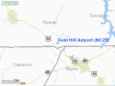
Location & QuickFacts
| FAA Information Effective: | 2008-09-25 |
| Airport Identifier: | NC25 |
| Airport Status: | Operational |
| Longitude/Latitude: | 080-18-40.2060W/35-30-32.5030N
-80.311168/35.509029 (Estimated) |
| Elevation: | 720 ft / 219.46 m (Surveyed) |
| Land: | 143 acres |
| From nearest city: | 2 nautical miles SE of Gold Hill, NC |
| Location: | Rowan County, NC |
| Magnetic Variation: | 06W (1985) |
Owner & Manager
| Ownership: | Privately owned |
| Owner: | Home Owners Association |
| Address: | 295 Fine St
Gold Hill, NC 28071 |
| Phone number: | 704-279-1078 |
| Manager: | Paul Kennedy |
| Address: | 295 Aviation Lane
Gold Hill, NC 28071 |
| Phone number: | 704-279-9795 |
Airport Operations and Facilities
| Airport Use: | Private |
| Wind indicator: | Yes |
| Segmented Circle: | No |
| Control Tower: | No |
| Lighting Schedule: | PHONE REQ
FOR LIRL RY 09/27 CALL 704-279-8711. |
| Landing fee charge: | No |
| Sectional chart: | Charlotte |
| Region: | ASO - Southern |
| Traffic Pattern Alt: | 1000 ft |
| Boundary ARTCC: | ZTL - Atlanta |
| Tie-in FSS: | RDU - Raleigh |
| FSS on Airport: | No |
| FSS Toll Free: | 1-800-WX-BRIEF |
Airport Communications
Airport Services
Runway Information
Runway 09/27
| Dimension: | 3000 x 30 ft / 914.4 x 9.1 m |
| Surface: | ASPH, |
| Edge Lights: | Low |
| |
Runway 09 |
Runway 27 |
| Traffic Pattern: | Left | Left |
| Obstruction: | | 30 ft trees, 500.0 ft from runway, 16:1 slope to clear |
|
Radio Navigation Aids
| ID |
Type |
Name |
Ch |
Freq |
Var |
Dist |
| VU | NDB | Aller | | 346.00 | 06W | 11.4 nm |
| RU | NDB | Rovdy | | 275.00 | 06W | 16.0 nm |
| SEN | NDB | Swearing/dcmsnd | | 260.00 | 06W | 16.3 nm |
| CQJ | NDB | City Lake | | 266.00 | 08W | 25.1 nm |
| DVZ | NDB | Davie | | 354.00 | 06W | 25.3 nm |
| AFP | NDB | Anson County | | 283.00 | 07W | 31.2 nm |
| IZN | NDB | Lincolnton | | 432.00 | 06W | 38.0 nm |
| TWL | NDB | Wesley | | 204.00 | 06W | 38.6 nm |
| VW | NDB | Temky | | 280.00 | 05W | 40.1 nm |
| TOX | NDB | Siler City | | 371.00 | 07W | 44.2 nm |
| HB | NDB | Himun | | 361.00 | 08W | 45.3 nm |
| GHJ | NDB | Stonia | | 260.00 | 06W | 45.7 nm |
| PYG | NDB | Pageland | | 270.00 | 06W | 45.9 nm |
| RCZ | NDB | Roscoe | | 375.00 | 07W | 49.8 nm |
| HFF | NDB | Mackall | | 278.00 | 06W | 49.8 nm |
| CLT | VOR/DME | Charlotte | 097X | 115.00 | 05W | 36.8 nm |
| GSO | VORTAC | Greensboro | 109X | 116.20 | 03W | 36.2 nm |
| LIB | VORTAC | Liberty | 077X | 113.00 | 03W | 38.7 nm |
| SDZ | VORTAC | Sandhills | 055X | 111.80 | 03W | 39.6 nm |
| FML | VORTAC | Fort Mill | 071X | 112.40 | 02W | 44.4 nm |
| CLT | VOT | Charlotte | | 112.00 | | 35.5 nm |
Remarks
- RWY 09 25' TREES 170' FROM THR ON CNTRLN.
- OPERATIONS ARE CONDUCTED IN VFR WEATHER CONDITIONS.
Images and information placed above are from
http://www.airport-data.com/airport/NC25/
We thank them for the data!
| General Info
|
| Country |
United States
|
| State |
NORTH CAROLINA
|
| FAA ID |
NC25
|
| Latitude |
35-30-32.503N
|
| Longitude |
080-18-40.206W
|
| Elevation |
720 feet
|
| Near City |
GOLDHILL
|
We don't guarantee the information is fresh and accurate. The data may
be wrong or outdated.
For more up-to-date information please refer to other sources.
|
|


