 |
|
Triangle North Executive Airport
(Franklin County Airport) |
| IATA: LFN – ICAO: KLHZ – FAA LID: LHZ |
| Summary |
| Airport type |
Public |
| Owner |
Franklin County |
| Serves |
Louisburg, North Carolina |
| Elevation AMSL |
369 ft / 112 m |
| Coordinates |
36°01′24″N 078°19′49″W / 36.02333°N 78.33028°W / 36.02333; -78.33028 |
| Runways |
| Direction |
Length |
Surface |
| ft |
m |
| 5/23 |
5,498 |
1,676 |
Asphalt |
| Statistics (2008) |
| Aircraft operations |
62,800 |
| Based aircraft |
65 |
| Source: Federal Aviation Administration |
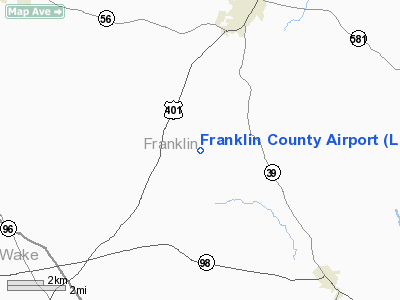
Triangle North Executive Airport (IATA: LFN, ICAO: KLHZ, FAA LID: LHZ) is a county-owned, public-use airport in Franklin County, North Carolina, United States. It is located five nautical miles (9 km) southwest of the central business district of Louisburg, North Carolina.
It was known as the Franklin County Regional Airport until November 2008, when the Board of Commissioners of Franklin County approved the new name.. As of February 2010, Federal Aviation Administration records give the airport's name as Franklin County Airport.
Although most U.S. airports use the same three-letter location identifier for the FAA and IATA, this airport is assigned LHZ by the FAA and LFN by the IATA. The airport's ICAO identifier is KLHZ.
Facilities and aircraft
The airport covers an area of 388 acres (157 ha) at an elevation of 369 feet (112 m) above mean sea level. It has one runway designated 5/23 with an asphalt surface measuring 5,498 by 100 feet (1,676 x 30 m).
For the 12-month period ending July 1, 2008, the airport had 62,800 aircraft operations, an average of 172 per day: 96% general aviation and 4% military. At that time there were 65 aircraft based at this airport: 83% single-engine, 6% multi-engine, 2% jet and 9% helicopter.
The above content comes from Wikipedia and is published under free licenses – click here to read more.
 |
(Click on the photo to enlarge) |
Location & QuickFacts
| FAA Information Effective: | 2008-09-25 |
| Airport Identifier: | LHZ |
| Airport Status: | Operational |
| Longitude/Latitude: | 078-19-48.9770W/36-01-24.0430N
-78.330271/36.023345 (Estimated) |
| Elevation: | 369 ft / 112.47 m (Surveyed) |
| Land: | 388 acres |
| From nearest city: | 5 nautical miles SW of Louisburg, NC |
| Location: | Franklin County, NC |
| Magnetic Variation: | 08W (1995) |
Owner & Manager
| Ownership: | Publicly owned |
| Owner: | Franklin County |
| Address: | 113 Market Street
Louisburg, NC 27549 |
| Phone number: | 919-554-1863 |
| Manager: | Ronnie Goswick |
| Address: | 440 Airport Drive
Louisburg, NC 27549 |
| Phone number: | 919-496-1234 |
Airport Operations and Facilities
| Airport Use: | Open to public |
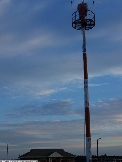
| Wind indicator: | Yes |
| Segmented Circle: | Yes |
| Control Tower: | No |
| Lighting Schedule: | DUSK-DAWN
ACTVT MIRL RY 05/23 & REIL RYS 05 & 23 - CTAF; AFTER DUSK ACTVT PAPI RYS 05 & 23 - CTAF. |
| Beacon Color: | Clear-Green (lighted land airport) |
| Sectional chart: | Washington |
| Region: | ASO - Southern |
| Boundary ARTCC: | ZDC - Washington |
| Tie-in FSS: | RDU - Raleigh |
| FSS on Airport: | No |
| FSS Toll Free: | 1-800-WX-BRIEF |
| NOTAMs Facility: | LHZ (NOTAM-d service avaliable) |
| Federal Agreements: | NGY |
Airport Communications
| CTAF: | 123.000 |
| Unicom: | 123.000 |
Airport Services
| Fuel available: | 100LLA1+ |
| Airframe Repair: | MAJOR |
| Power Plant Repair: | MAJOR |
Runway Information
Runway 05/23
| Dimension: | 5500 x 100 ft / 1676.4 x 30.5 m |
| Surface: | ASPH, Good Condition |
| Weight Limit: | Single wheel: 40000 lbs.
Dual wheel: 60000 lbs. |
| Edge Lights: | Medium |
| |
Runway 05 |
Runway 23 |
| Longitude: | 078-20-09.3500W | 078-19-28.6030W |
| Latitude: | 36-01-02.4600N | 36-01-45.6250N |
| Elevation: | 366.00 ft | 330.00 ft |
| Alignment: | 37 | 127 |
| ILS Type: | ILS/DME
| |
| Traffic Pattern: | Right | Left |
| Markings: | Precision instrument, Good Condition | Non-precision instrument, Good Condition |
| Crossing Height: | 23.00 ft | 46.00 ft |
| VASI: | 2-light PAPI on left side | 2-light PAPI on left side |
| Visual Glide Angle: | 3.00° | 3.00° |
| Approach lights: | MALSF | |
| Runway End Identifier: | No | Yes |
| Obstruction: | 28 ft trees, 639.0 ft from runway, 487 ft right of centerline, 15:1 slope to clear | 44 ft trees, 885.0 ft from runway, 467 ft left of centerline, 15:1 slope to clear
2 FT RISING GROUND 157 FT FROM THLD BOTH SIDES OF CNTRLN. |
|
Radio Navigation Aids
| ID |
Type |
Name |
Ch |
Freq |
Var |
Dist |
| LE | NDB | Leevy | | 350.00 | 07W | 19.9 nm |
| HXO | NDB | Huntsboro | | 271.00 | 07W | 21.8 nm |
| RW | NDB | Jambe | | 235.00 | 09W | 23.5 nm |
| EUU | NDB | Jnall | | 251.00 | 07W | 25.1 nm |
| JN | NDB | Jurly | | 263.00 | 09W | 33.3 nm |
| JYN | NDB | Wayne | | 208.00 | 08W | 36.5 nm |
| HUR | NDB | Person | | 220.00 | 08W | 37.9 nm |
| AEA | NDB | Jones | | 373.00 | 09W | 38.0 nm |
| ETC | NDB | Tarboro | | 257.00 | 08W | 38.5 nm |
| RZZ | NDB | Rapids | | 407.00 | 08W | 39.2 nm |
| HQT | NDB | Harnett | | 417.00 | 08W | 39.3 nm |
| MBV | NDB | Mecklenburg/dcmsnd | | 356.00 | 08W | 42.3 nm |
| GSB | TACAN | Seymour Johnson | 112X | | 08W | 44.9 nm |
| RDU | VORTAC | Raleigh/durham | 119X | 117.20 | 04W | 23.8 nm |
| TYI | VORTAC | Tar River | 125X | 117.80 | 05W | 30.6 nm |
Remarks
- ARPT PHONE 919-496-1234; FOR SERVICES AFTER HOURS CALL 919-729-4118.
- BIRDS ON & INVOF ARPT.
- GCO AVBL ON FREQ 135.075 THRU RDU CLEARANCE DELIVERY.
- NO OBJECTION.
Images and information placed above are from
http://www.airport-data.com/airport/LHZ/
We thank them for the data!
| General Info
|
| Country |
United States
|
| State |
NORTH CAROLINA
|
| FAA ID |
LHZ
|
| Latitude |
36-01-24.043N
|
| Longitude |
078-19-48.977W
|
| Elevation |
369 feet
|
| Near City |
LOUISBURG
|
We don't guarantee the information is fresh and accurate. The data may
be wrong or outdated.
For more up-to-date information please refer to other sources.
|
|


