 |
|
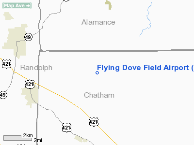
Flying Dove Field Airport |
Location & QuickFacts
| FAA Information Effective: | 2008-09-25 |
| Airport Identifier: | 22NC |
| Airport Status: | Operational |
| Longitude/Latitude: | 079-28-06.0000W/35-49-16.0000N
-79.468333/35.821111 (Estimated) |
| Elevation: | 650 ft / 198.12 m (Estimated) |
| Land: | 0 acres |
| From nearest city: | 5 nautical miles N of Siler City, NC |
| Location: | Chatham County, NC |
| Magnetic Variation: | 07W (1995) |
Owner & Manager
| Ownership: | Privately owned |
| Owner: | Barry R. Inman |
| Address: | 6496 Silk Hope Liberty Rd
Siler City, NC 27344 |
| Phone number: | 336-996-2418 |
| Manager: | Barry R. Inman |
| Address: | 6496 Silk Hope Liberty Rd
Siler City, NC 27344 |
| Phone number: | 336-996-2418 |
Airport Operations and Facilities
| Airport Use: | Private |
| Wind indicator: | Yes |
| Segmented Circle: | No |
| Control Tower: | No |
| Sectional chart: | Charlotte |
| Region: | ASO - Southern |
| Boundary ARTCC: | ZDC - Washington |
| Tie-in FSS: | RDU - Raleigh |
| FSS on Airport: | No |
| FSS Toll Free: | 1-800-WX-BRIEF |
Runway Information
Runway 18/36
| Dimension: | 2500 x 100 ft / 762.0 x 30.5 m |
| Surface: | TURF, Poor Condition
CONDITION ROUGH. |
| |
Runway 18 |
Runway 36 |
| Traffic Pattern: | Left | Left |
| Displaced threshold: | 500.00 ft | 500.00 ft |
| Obstruction: | 30 ft trees, 50.0 ft from runway | 30 ft trees, 50.0 ft from runway |
|
Radio Navigation Aids
| ID |
Type |
Name |
Ch |
Freq |
Var |
Dist |
| OQA | FAN MARKER | Rockingham County | | | | 40.4 nm |
| TOX | NDB | Siler City | | 371.00 | 07W | 3.6 nm |
| HB | NDB | Himun | | 361.00 | 08W | 11.0 nm |
| CQJ | NDB | City Lake | | 266.00 | 08W | 20.4 nm |
| TT | NDB | Leeco | | 406.00 | 08W | 25.2 nm |
| EEJ | NDB | Lee County/dcmsnd | | 428.00 | 07W | 29.5 nm |
| HUR | NDB | Person | | 220.00 | 08W | 31.6 nm |
| VU | NDB | Aller | | 346.00 | 06W | 36.0 nm |
| SIF | NDB | Slammer | | 423.00 | 07W | 36.6 nm |
| LE | NDB | Leevy | | 350.00 | 07W | 36.9 nm |
| SEN | NDB | Swearing/dcmsnd | | 260.00 | 06W | 40.5 nm |
| POB | NDB | Pope | | 338.00 | 07W | 43.7 nm |
| HQT | NDB | Harnett | | 417.00 | 08W | 45.2 nm |
| HFF | NDB | Mackall | | 278.00 | 06W | 47.7 nm |
| DVZ | NDB | Davie | | 354.00 | 06W | 48.4 nm |
| POB | TACAN | Pope | 085X | | 07W | 45.4 nm |
| DAN | VOR | Danville | | 113.10 | 06W | 45.4 nm |
| LIB | VORTAC | Liberty | 077X | 113.00 | 03W | 7.1 nm |
| GSO | VORTAC | Greensboro | 109X | 116.20 | 03W | 28.2 nm |
| RDU | VORTAC | Raleigh/durham | 119X | 117.20 | 04W | 33.5 nm |
| SDZ | VORTAC | Sandhills | 055X | 111.80 | 03W | 36.9 nm |
Remarks
- PRVDD VFR/PR USE AND COORD TFC PATS WITH SILER CITY AND HENSHAW ARPTS.
Images and information placed above are from
http://www.airport-data.com/airport/22NC/
We thank them for the data!
| General Info
|
| Country |
United States
|
| State |
NORTH CAROLINA
|
| FAA ID |
22NC
|
| Latitude |
35-49-16.000N
|
| Longitude |
079-28-06.000W
|
| Elevation |
650 feet
|
| Near City |
SILER CITY
|
We don't guarantee the information is fresh and accurate. The data may
be wrong or outdated.
For more up-to-date information please refer to other sources.
|
|


