 |
|
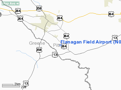
Location & QuickFacts
| FAA Information Effective: | 2008-09-25 |
| Airport Identifier: | N08 |
| Airport Status: | Operational |
| Longitude/Latitude: | 077-33-38.0000W/35-33-24.0000N
-77.560556/35.556667 (Estimated) |
| Elevation: | 75 ft / 22.86 m (Estimated) |
| Land: | 12 acres |
| From nearest city: | 3 nautical miles SE of Farmville, NC |
| Location: | Pitt County, NC |
| Magnetic Variation: | 08W (1985) |
Owner & Manager
| Ownership: | Privately owned |
| Owner: | Harold Flanagan |
| Address: | 3625 Arch Flanagan Road
Farmville, NC 27828 |
| Phone number: | 252-341-4059 |
| Manager: | Harold Flanagan |
| Address: | 3625 Arch Flanagan Road
Farmville, NC 27828 |
| Phone number: | 252-341-4059 |
Airport Operations and Facilities
| Airport Use: | Open to public |
| Wind indicator: | Yes |
| Segmented Circle: | No |
| Control Tower: | No |
| Sectional chart: | Charlotte |
| Region: | ASO - Southern |
| Boundary ARTCC: | ZDC - Washington |
| Tie-in FSS: | RDU - Raleigh |
| FSS Toll Free: | 1-800-WX-BRIEF |
| NOTAMs Facility: | RDU (NOTAM-d service avaliable) |
Airport Communications
Airport Services
| Fuel available: | 100LL |
| Airframe Repair: | NONE |
| Power Plant Repair: | NONE |
Runway Information
Runway 03/21
| Dimension: | 2500 x 100 ft / 762.0 x 30.5 m |
| Surface: | TURF, Good Condition |
| |
Runway 03 |
Runway 21 |
| Traffic Pattern: | Left | Left |
| Markings: | Nonstandard,
RY 03/21 MKD WITH YELLOW CONES. | Nonstandard,
RY 21 NO DSPLCD THLD MKGS. |
| Displaced threshold: | 0.00 ft | 300.00 ft |
| Obstruction: | 76 ft trees, 183.0 ft from runway, 133 ft left of centerline, 2:1 slope to clear | 39 ft trees, 1.0 ft from runway, 82 ft left of centerline
0:1 APCH SLOPE DUE TO 39 FT TREES 82 FT. LEFT OF CTRLN. 8:1 APCH SLOPE FM 300 FT DSPLCD THLD. |
|
Radio Navigation Aids
| ID |
Type |
Name |
Ch |
Freq |
Var |
Dist |
| PGV | FAN MARKER | Belvoir | | | 06W | 10.0 nm |
| AQE | NDB | Alwood | | 230.00 | 09W | 12.9 nm |
| JYN | NDB | Wayne | | 208.00 | 08W | 16.7 nm |
| RNW | NDB | Chocowinity | | 388.00 | 07W | 22.4 nm |
| ETC | NDB | Tarboro | | 257.00 | 08W | 22.8 nm |
| RW | NDB | Jambe | | 235.00 | 09W | 23.5 nm |
| MCZ | NDB | Williamston | | 336.00 | 09W | 26.1 nm |
| DKA | NDB | Kenan | | 332.00 | 07W | 34.0 nm |
| EUU | NDB | Jnall | | 251.00 | 07W | 38.9 nm |
| PMZ | NDB | Plymouth | | 221.00 | 10W | 41.8 nm |
| JN | NDB | Jurly | | 263.00 | 09W | 42.6 nm |
| ASJ | NDB | Ahoskie | | 415.00 | 10W | 48.4 nm |
| GSB | TACAN | Seymour Johnson | 112X | | 08W | 24.1 nm |
| EWN | VOR/DME | New Bern | 083X | 113.60 | 08W | 38.5 nm |
| ISO | VORTAC | Kinston | 033X | 109.60 | 05W | 11.2 nm |
| TYI | VORTAC | Tar River | 125X | 117.80 | 05W | 26.2 nm |
Remarks
- GLIDER OPNS INVOF ARPT.
- AERIAL BANNER TOWING AND AERIAL CROP SPRAYING INVOF AIRPORT.
- LIVESTOCK AND WILDLIFE INVOF ARPT
- +4 FT FENCE WITH BRUSH ALONG HWY AT NE END OF RY 21.
Images and information placed above are from
http://www.airport-data.com/airport/N08/
We thank them for the data!
| General Info
|
| Country |
United States
|
| State |
NORTH CAROLINA
|
| FAA ID |
N08
|
| Latitude |
35-33-24.000N
|
| Longitude |
077-33-38.000W
|
| Elevation |
75 feet
|
| Near City |
FARMVILLE
|
We don't guarantee the information is fresh and accurate. The data may
be wrong or outdated.
For more up-to-date information please refer to other sources.
|
|


