 |
|
Eastover Air Ranch Airport |
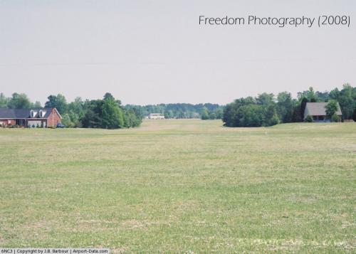 |
(Click on the photo to enlarge) |
Location & QuickFacts
| FAA Information Effective: | 2008-09-25 |
| Airport Identifier: | 6NC3 |
| Airport Status: | Operational |
| Longitude/Latitude: | 078-46-20.0000W/35-05-11.0000N
-78.772222/35.086389 (Estimated) |
| Elevation: | 160 ft / 48.77 m (Surveyed) |
| Land: | 10 acres |
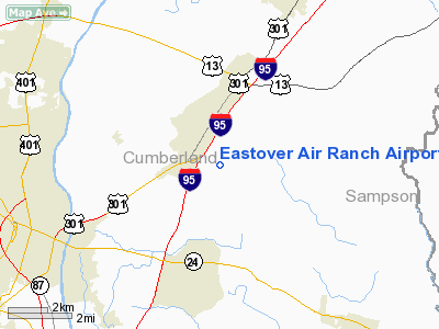
| From nearest city: | 6 nautical miles NE of Fayetteville, NC |
| Location: | Cumberland County, NC |
| Magnetic Variation: | 07W (1990) |
Owner & Manager
| Ownership: | Privately owned |
| Owner: | K-land Corporation |
| Address: | Rt 16, Box 190
Fayetteville, NC 28301 |
| Phone number: | 910-483-7649 |
| Manager: | Kenneth Kubinski |
| Address: | Rt 16, Box 190
Fayetteville, NC 28301 |
| Phone number: | 910-323-1596 |
Airport Operations and Facilities
| Airport Use: | Private |
| Wind indicator: | Yes |
| Segmented Circle: | No |
| Control Tower: | No |
| Sectional chart: | Charlotte |
| Region: | ASO - Southern |
| Boundary ARTCC: | ZDC - Washington |
| Tie-in FSS: | RDU - Raleigh |
| FSS Toll Free: | 1-800-WX-BRIEF |
Runway Information
Runway 04/22
| Dimension: | 3000 x 300 ft / 914.4 x 91.4 m |
| Surface: | TURF, |
| |
Runway 04 |
Runway 22 |
| Traffic Pattern: | Left | Left |
|
Radio Navigation Aids
| ID |
Type |
Name |
Ch |
Freq |
Var |
Dist |
| FGP | NDB | Fort Bragg | | 393.00 | 07W | 3.7 nm |
| POB | NDB | Pope | | 338.00 | 07W | 12.3 nm |
| CTZ | NDB | Clinton | | 412.00 | 08W | 21.2 nm |
| HQT | NDB | Harnett | | 417.00 | 08W | 21.4 nm |
| EEJ | NDB | Lee County/dcmsnd | | 428.00 | 07W | 28.1 nm |
| JN | NDB | Jurly | | 263.00 | 09W | 28.9 nm |
| TT | NDB | Leeco | | 406.00 | 08W | 30.6 nm |
| RSY | NDB | Robeson | | 359.00 | 08W | 31.8 nm |
| HFF | NDB | Mackall | | 278.00 | 06W | 35.3 nm |
| TGQ | NDB | Elizabethtown | | 398.00 | 08W | 35.8 nm |
| JB | NDB | Jigel | | 384.00 | 08W | 37.2 nm |
| EUU | NDB | Jnall | | 251.00 | 07W | 37.4 nm |
| ME | NDB | Maxtn | | 257.00 | 08W | 39.3 nm |
| DKA | NDB | Kenan | | 332.00 | 07W | 42.0 nm |
| ACZ | NDB | Pendy | | 379.00 | 09W | 43.9 nm |
| RCZ | NDB | Roscoe | | 375.00 | 07W | 47.5 nm |
| DLC | NDB | Dillon | | 274.00 | 05W | 48.3 nm |
| CPC | NDB | Camp | | 227.00 | 07W | 49.0 nm |
| POB | TACAN | Pope | 085X | | 07W | 13.0 nm |
| GSB | TACAN | Seymour Johnson | 112X | | 08W | 42.1 nm |
| LBT | VOR | Lumberton | | 110.00 | 08W | 31.8 nm |
| FAY | VOR/DME | Fayetteville | 025X | 108.80 | 04W | 7.9 nm |
| SDZ | VORTAC | Sandhills | 055X | 111.80 | 03W | 40.8 nm |
| RDU | VORTAC | Raleigh/durham | 119X | 117.20 | 04W | 47.3 nm |
Remarks
- PRVDD ALL OPNS CONDUCTED IN VFR WX CONDS; LNDG AREA LIMITED TO PVT USE.
Images and information placed above are from
http://www.airport-data.com/airport/6NC3/
We thank them for the data!
| General Info
|
| Country |
United States
|
| State |
NORTH CAROLINA
|
| FAA ID |
6NC3
|
| Latitude |
35-05-11.000N
|
| Longitude |
078-46-20.000W
|
| Elevation |
160 feet
|
| Near City |
FAYETTEVILLE
|
We don't guarantee the information is fresh and accurate. The data may
be wrong or outdated.
For more up-to-date information please refer to other sources.
|
|


