 |
|
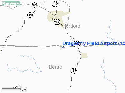
Location & QuickFacts
| FAA Information Effective: | 2008-09-25 |
| Airport Identifier: | 15NC |
| Airport Status: | Operational |
| Longitude/Latitude: | 076-58-26.0000W/36-14-23.0000N
-76.973889/36.239722 (Estimated) |
| Elevation: | 49 ft / 14.94 m (Estimated) |
| Land: | 40 acres |
| From nearest city: | 3 nautical miles N of Ahoskie, NC |
| Location: | Hertford County, NC |
| Magnetic Variation: | 09W () |
Owner & Manager
| Ownership: | Privately owned |
| Owner: | Michael A. & Deborah V. Spalding |
| Address: | 414 South Williford Road
Ahoskie, NC 27910 |
| Phone number: | 252-332-7690 |
| Manager: | Michael A. & Deborah V. Spalding |
| Address: | 414 South Williford Road
Ahoskie, NC 27910 |
| Phone number: | 252-332-7690 |
Airport Operations and Facilities
| Airport Use: | Private |
| Wind indicator: | Yes |
| Segmented Circle: | No |
| Control Tower: | No |
| Sectional chart: | Washington |
| Region: | ASO - Southern |
| Boundary ARTCC: | ZDC - Washington |
| Tie-in FSS: | RDU - Raleigh |
| FSS Toll Free: | 1-800-WX-BRIEF |
Runway Information
Runway 14/32
| Dimension: | 1800 x 50 ft / 548.6 x 15.2 m |
| Surface: | TURF, |
| |
Runway 14 |
Runway 32 |
| Traffic Pattern: | Right | Left |
|
Radio Navigation Aids
| ID |
Type |
Name |
Ch |
Freq |
Var |
Dist |
| PGV | FAN MARKER | Belvoir | | | 06W | 41.2 nm |
| ASJ | NDB | Ahoskie | | 415.00 | 10W | 10.4 nm |
| EDE | NDB | Edenton | | 265.00 | 10W | 23.6 nm |
| MCZ | NDB | Williamston | | 336.00 | 09W | 24.9 nm |
| RK | NDB | Waley | | 249.00 | 10W | 26.7 nm |
| PMZ | NDB | Plymouth | | 221.00 | 10W | 27.8 nm |
| ELQ | NDB | Emporia | | 261.00 | 10W | 31.5 nm |
| LLW | NDB | Woodville | | 254.00 | 10W | 32.8 nm |
| ETC | NDB | Tarboro | | 257.00 | 08W | 33.3 nm |
| EY | NDB | Chesi | | 233.00 | 09W | 35.9 nm |
| AQE | NDB | Alwood | | 230.00 | 09W | 37.4 nm |
| RZZ | NDB | Rapids | | 407.00 | 08W | 37.6 nm |
| PVG | NDB | Portsmouth | | 241.00 | 10W | 41.3 nm |
| RNW | NDB | Chocowinity | | 388.00 | 07W | 44.4 nm |
| AKQ | NDB | Wakefield | | 274.00 | 09W | 44.7 nm |
| ECG | VOR/DME | Elizabeth City | 072X | 112.50 | 07W | 38.7 nm |
| CVI | VORTAC | Cofield | 093X | 114.60 | 09W | 9.4 nm |
| FKN | VORTAC | Franklin | 043X | 110.60 | 09W | 28.6 nm |
| TYI | VORTAC | Tar River | 125X | 117.80 | 05W | 38.8 nm |
Remarks
- OWNER DESIRES ARPT NOT BE CHARTED.
- PRVDD VFR, PVT USE.
Images and information placed above are from
http://www.airport-data.com/airport/15NC/
We thank them for the data!
| General Info
|
| Country |
United States
|
| State |
NORTH CAROLINA
|
| FAA ID |
15NC
|
| Latitude |
36-14-23.000N
|
| Longitude |
076-58-26.000W
|
| Elevation |
49 feet
|
| Near City |
AHOSKIE
|
We don't guarantee the information is fresh and accurate. The data may
be wrong or outdated.
For more up-to-date information please refer to other sources.
|
|


