 |
|
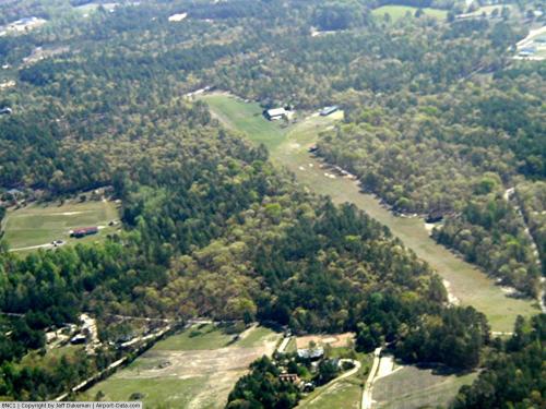 |
(Click on the photo to enlarge) |
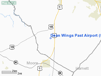
Location & QuickFacts
| FAA Information Effective: | 2008-09-25 |
| Airport Identifier: | 8NC1 |
| Airport Status: | Operational |
| Longitude/Latitude: | 079-14-27.0860W/35-22-34.5580N
-79.240857/35.376266 (Estimated) |
| Elevation: | 480 ft / 146.30 m (Estimated) |
| Land: | 5 acres |
| From nearest city: | 4 nautical miles NE of Cameron, NC |
| Location: | Lee County, NC |
| Magnetic Variation: | 07W (1985) |
Owner & Manager
| Ownership: | Privately owned |
| Owner: | James J Dean |
| Address: | 676 Oakleaf Road
Sanford, NC 27332 |
| Phone number: | 919-775-7810 |
| Manager: | James J Dean |
| Address: | 676 Oakleaf Road
Sanford, NC 27332 |
| Phone number: | 919-775-7810 |
Airport Operations and Facilities
| Airport Use: | Private |
| Wind indicator: | Yes |
| Segmented Circle: | No |
| Control Tower: | No |
| Sectional chart: | Charlotte |
| Region: | ASO - Southern |
| Boundary ARTCC: | ZDC - Washington |
| Tie-in FSS: | RDU - Raleigh |
| FSS on Airport: | No |
| FSS Toll Free: | 1-800-WX-BRIEF |
Runway Information
Runway 06/24
| Dimension: | 2400 x 150 ft / 731.5 x 45.7 m |
| Surface: | TURF, |
| |
Runway 06 |
Runway 24 |
| Traffic Pattern: | Left | Left |
|
Radio Navigation Aids
| ID |
Type |
Name |
Ch |
Freq |
Var |
Dist |
| EEJ | NDB | Lee County/dcmsnd | | 428.00 | 07W | 0.9 nm |
| TT | NDB | Leeco | | 406.00 | 08W | 8.8 nm |
| POB | NDB | Pope | | 338.00 | 07W | 16.7 nm |
| HFF | NDB | Mackall | | 278.00 | 06W | 24.1 nm |
| FGP | NDB | Fort Bragg | | 393.00 | 07W | 25.4 nm |
| TOX | NDB | Siler City | | 371.00 | 07W | 25.6 nm |
| HQT | NDB | Harnett | | 417.00 | 08W | 27.9 nm |
| CQJ | NDB | City Lake | | 266.00 | 08W | 36.7 nm |
| RCZ | NDB | Roscoe | | 375.00 | 07W | 38.6 nm |
| ME | NDB | Maxtn | | 257.00 | 08W | 39.9 nm |
| HB | NDB | Himun | | 361.00 | 08W | 39.9 nm |
| JN | NDB | Jurly | | 263.00 | 09W | 40.4 nm |
| VU | NDB | Aller | | 346.00 | 06W | 41.7 nm |
| LE | NDB | Leevy | | 350.00 | 07W | 41.7 nm |
| EUU | NDB | Jnall | | 251.00 | 07W | 45.5 nm |
| AFP | NDB | Anson County | | 283.00 | 07W | 46.5 nm |
| RSY | NDB | Robeson | | 359.00 | 08W | 46.7 nm |
| CQW | NDB | Cheraw | | 409.00 | 05W | 49.0 nm |
| CTZ | NDB | Clinton | | 412.00 | 08W | 49.4 nm |
| POB | TACAN | Pope | 085X | | 07W | 16.9 nm |
| LBT | VOR | Lumberton | | 110.00 | 08W | 46.9 nm |
| FAY | VOR/DME | Fayetteville | 025X | 108.80 | 04W | 29.6 nm |
| SDZ | VORTAC | Sandhills | 055X | 111.80 | 03W | 19.6 nm |
| LIB | VORTAC | Liberty | 077X | 113.00 | 03W | 31.9 nm |
| RDU | VORTAC | Raleigh/durham | 119X | 117.20 | 04W | 37.3 nm |
Remarks
- PRVDD VFR PRIVATE USE ONLY.
Images and information placed above are from
http://www.airport-data.com/airport/8NC1/
We thank them for the data!
| General Info
|
| Country |
United States
|
| State |
NORTH CAROLINA
|
| FAA ID |
8NC1
|
| Latitude |
35-22-34.558N
|
| Longitude |
079-14-27.086W
|
| Elevation |
480 feet
|
| Near City |
CAMERON
|
We don't guarantee the information is fresh and accurate. The data may
be wrong or outdated.
For more up-to-date information please refer to other sources.
|
|


