 |
|
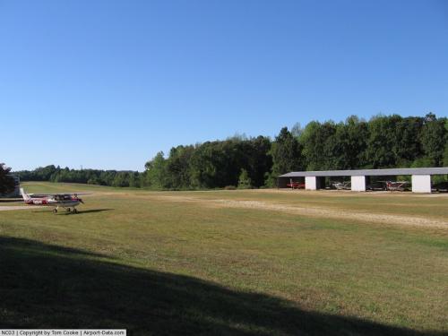 |
(Click on the photo to enlarge) |
Location & QuickFacts
| FAA Information Effective: | 2008-09-25 |
| Airport Identifier: | NC03 |
| Airport Status: | Operational |
| Longitude/Latitude: | 079-59-14.1410W/35-54-30.4910N
-79.987261/35.908470 (Estimated) |
| Elevation: | 874 ft / 266.40 m (Estimated) |
| Land: | 40 acres |
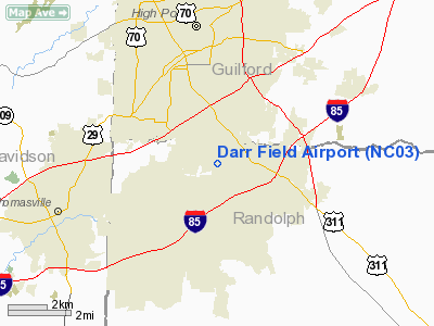
| From nearest city: | 3 nautical miles S of High Point, NC |
| Location: | Randolph County, NC |
| Magnetic Variation: | 06W (1985) |
Owner & Manager
| Ownership: | Privately owned |
| Owner: | High Point Trinity Air Service |
| Address: | Po Box 7163
High Point, NC 27264 |
| Phone number: | 336-431-9158 |
| Manager: | Jacob L. Darr |
| Address: | 100 Sealy Dr
Trinity, NC 27370 |
| Phone number: | 336-434-4239 |
Airport Operations and Facilities
| Airport Use: | Private |
| Wind indicator: | Yes |
| Segmented Circle: | No |
| Control Tower: | No |
| Landing fee charge: | No |
| Sectional chart: | Charlotte |
| Region: | ASO - Southern |
| Boundary ARTCC: | ZTL - Atlanta |
| Tie-in FSS: | RDU - Raleigh |
| FSS on Airport: | No |
| FSS Toll Free: | 1-800-WX-BRIEF |
Airport Services
| Airframe Repair: | NONE |
| Power Plant Repair: | NONE |
| Bottled Oxygen: | NONE |
| Bulk Oxygen: | NONE |
Runway Information
Runway 13/31
| Dimension: | 2365 x 60 ft / 720.9 x 18.3 m |
| Surface: | TURFRVL, Good Condition
OUTER 20' ON EACH SIDE OF RWY IS TURF. CENTER 20' IS SAND & ROCK. FIRST 300' RWY 13 IS ROUGH. |
| |
Runway 13 |
Runway 31 |
| Traffic Pattern: | Left | Left |
| Obstruction: | 25 ft rr, 70 ft right of centerline | 45 ft trees, 0.0 ft from runway, 80 ft left of centerline |
|
Radio Navigation Aids
| ID |
Type |
Name |
Ch |
Freq |
Var |
Dist |
| OQA | FAN MARKER | Rockingham County | | | | 32.1 nm |
| CQJ | NDB | City Lake | | 266.00 | 08W | 13.0 nm |
| SEN | NDB | Swearing/dcmsnd | | 260.00 | 06W | 17.0 nm |
| HB | NDB | Himun | | 361.00 | 08W | 20.0 nm |
| DVZ | NDB | Davie | | 354.00 | 06W | 22.8 nm |
| VU | NDB | Aller | | 346.00 | 06W | 25.6 nm |
| RU | NDB | Rovdy | | 275.00 | 06W | 26.7 nm |
| TOX | NDB | Siler City | | 371.00 | 07W | 27.1 nm |
| SIF | NDB | Slammer | | 423.00 | 07W | 30.5 nm |
| AZW | NDB | Mount Airy | | 223.00 | 07W | 39.1 nm |
| UV | NDB | Bales | | 396.00 | 07W | 41.1 nm |
| ZEF | NDB | Zephyr | | 326.00 | 05W | 43.2 nm |
| TT | NDB | Leeco | | 406.00 | 08W | 48.2 nm |
| HUR | NDB | Person | | 220.00 | 08W | 48.8 nm |
| EEJ | NDB | Lee County/dcmsnd | | 428.00 | 07W | 49.3 nm |
| GSO | VORTAC | Greensboro | 109X | 116.20 | 03W | 8.3 nm |
| LIB | VORTAC | Liberty | 077X | 113.00 | 03W | 19.2 nm |
| SDZ | VORTAC | Sandhills | 055X | 111.80 | 03W | 46.0 nm |
Remarks
Images and information placed above are from
http://www.airport-data.com/airport/NC03/
We thank them for the data!
| General Info
|
| Country |
United States
|
| State |
NORTH CAROLINA
|
| FAA ID |
NC03
|
| Latitude |
35-54-30.491N
|
| Longitude |
079-59-14.141W
|
| Elevation |
874 feet
|
| Near City |
HIGH POINT
|
We don't guarantee the information is fresh and accurate. The data may
be wrong or outdated.
For more up-to-date information please refer to other sources.
|
|


