 |
|
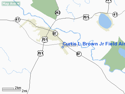
Curtis L Brown Jr Field Airport |
| Curtis L. Brown Jr. Field |
| IATA: none – ICAO: KEYF – FAA LID: EYF |
| Summary |
| Airport type |
Elizabethtown Airport & Economic Development Commission |
| Operator |
Elizabethtown, North Carolina |
| Location |
132 |
| Elevation AMSL |
40.2 ft / m |
| Coordinates |
34°36′06″N 078°34′45″W / 34.60167°N 78.57917°W / 34.60167; -78.57917Coordinates: 34°36′06″N 078°34′45″W / 34.60167°N 78.57917°W / 34.60167; -78.57917 |
| Runways |
| Direction |
Length |
Surface |
| ft |
m |
| 15/33 |
5,001 |
1,524 |
Asphalt |
Curtis L. Brown Jr. Field (ICAO: KEYF, FAA LID: EYF) is a public airport located two miles (3 km) southeast of the central business district (CBD) of Elizabethtown, a town in Bladen County, North Carolina, USA. This general aviation airport covers 212 acres (86 ha) and has one runway.
The above content comes from Wikipedia and is published under free licenses – click here to read more.
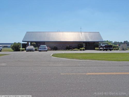 |
(Click on the photo to enlarge) |
Location & QuickFacts
| FAA Information Effective: | 2008-09-25 |
| Airport Identifier: | EYF |
| Airport Status: | Operational |
| Longitude/Latitude: | 078-34-45.3750W/34-36-06.4950N
-78.579271/34.601804 (Estimated) |
| Elevation: | 132 ft / 40.23 m (Surveyed) |
| Land: | 212 acres |
| From nearest city: | 2 nautical miles SE of Elizabethtown, NC |
| Location: | Bladen County, NC |
| Magnetic Variation: | 08W (2000) |
Owner & Manager
| Ownership: | Publicly owned |
| Owner: | Town Of Elizabethtown |
| Address: | Po Box 716
Elizabethtown, NC 28337 |
| Phone number: | 910-862-2066 |
| Manager: | Oscar Taylor |
| Address: | 466 Airport Rd
Elizabethtown, NC 28337 |
| Phone number: | 910-862-4522 |
Airport Operations and Facilities
| Airport Use: | Open to public |
| Wind indicator: | Yes |
| Segmented Circle: | Yes |
| Control Tower: | No |
| Lighting Schedule: | DUSK-DAWN
ACTVT MIRL RY 15/33; PAPI RYS 15/33 & REIL RY 33 - CTAF. |
| Beacon Color: | Clear-Green (lighted land airport) |
| Landing fee charge: | No |
| Sectional chart: | Charlotte |
| Region: | ASO - Southern |
| Boundary ARTCC: | ZDC - Washington |
| Tie-in FSS: | RDU - Raleigh |
| FSS on Airport: | No |
| FSS Toll Free: | 1-800-WX-BRIEF |
| NOTAMs Facility: | RDU (NOTAM-d service avaliable) |
| Federal Agreements: | N |
Airport Communications
| CTAF: | 122.800 |
| Unicom: | 122.800 |
Airport Services
| Fuel available: | 100LLA1+
FUEL AVBL 24 HRS WITH CREDIT CARD. |
| Airframe Repair: | MINOR |
| Power Plant Repair: | MINOR |
Runway Information
Runway 15/33
| Dimension: | 5001 x 75 ft / 1524.3 x 22.9 m |
| Surface: | ASPH, Good Condition |
| Weight Limit: | Single wheel: 30000 lbs.
Dual wheel: 45000 lbs. |
| Edge Lights: | Medium |
| |
Runway 15 |
Runway 33 |
| Longitude: | 078-35-02.8800W | 078-34-27.8700W |
| Latitude: | 34-36-26.5500N | 34-35-46.4400N |
| Elevation: | 129.00 ft | 122.00 ft |
| Alignment: | 127 | 127 |
| Traffic Pattern: | Left | Left |
| Markings: | Non-precision instrument, Good Condition | Non-precision instrument, Good Condition |
| Crossing Height: | 45.00 ft | 33.00 ft |
| VASI: | 2-light PAPI on left side | 2-light PAPI on left side |
| Visual Glide Angle: | 4.20° | 3.00° |
| Runway End Identifier: | | Yes |
|
Radio Navigation Aids
| ID |
Type |
Name |
Ch |
Freq |
Var |
Dist |
| TGQ | NDB | Elizabethtown | | 398.00 | 08W | 5.4 nm |
| CPC | NDB | Camp | | 227.00 | 07W | 20.9 nm |
| RSY | NDB | Robeson | | 359.00 | 08W | 23.8 nm |
| CTZ | NDB | Clinton | | 412.00 | 08W | 24.9 nm |
| JB | NDB | Jigel | | 384.00 | 08W | 27.9 nm |
| ACZ | NDB | Pendy | | 379.00 | 09W | 29.3 nm |
| FGP | NDB | Fort Bragg | | 393.00 | 07W | 34.3 nm |
| DLC | NDB | Dillon | | 274.00 | 05W | 40.1 nm |
| POB | NDB | Pope | | 338.00 | 07W | 41.9 nm |
| CLB | NDB | Carolina Beach | | 216.00 | 04W | 42.7 nm |
| DKA | NDB | Kenan | | 332.00 | 07W | 43.1 nm |
| ME | NDB | Maxtn | | 257.00 | 08W | 43.5 nm |
| MAO | NDB | Marion | | 388.00 | 06W | 45.0 nm |
| SUT | NDB | Yaupon | | 233.00 | 08W | 47.6 nm |
| POB | TACAN | Pope | 085X | | 07W | 40.0 nm |
| LBT | VOR | Lumberton | | 110.00 | 08W | 23.5 nm |
| FAY | VOR/DME | Fayetteville | 025X | 108.80 | 04W | 27.3 nm |
| ILM | VORTAC | Wilmington | 117X | 117.00 | 07W | 38.0 nm |
| CRE | VORTAC | Grand Strand | 123X | 117.60 | 03W | 47.9 nm |
Remarks
- BIRDS ON AND INVOF ARPT SPRING & FALL.
- LOW LEVEL MILITARY ACTVTY INVOF ARPT.
- DEER ON AND INVOF AIRPORT.
- AIRPORT BEACON IS OBSCURED BY TREES TO THE EAST.
- VFR ONLY.
Images and information placed above are from
http://www.airport-data.com/airport/EYF/
We thank them for the data!
| General Info
|
| Country |
United States
|
| State |
NORTH CAROLINA
|
| FAA ID |
EYF
|
| Latitude |
34-36-06.495N
|
| Longitude |
078-34-45.375W
|
| Elevation |
132 feet
|
| Near City |
ELIZABETHTOWN
|
We don't guarantee the information is fresh and accurate. The data may
be wrong or outdated.
For more up-to-date information please refer to other sources.
|
|


