 |
|
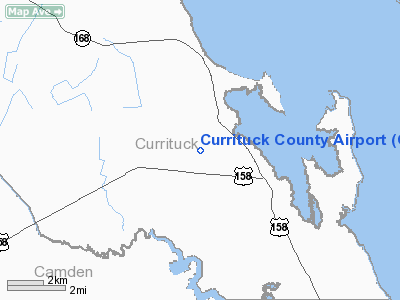
Currituck County Airport
Currituck Regional Airport |
| IATA: none – ICAO: KONX – FAA LID: ONX |
| Summary |
| Owner |
Currituck County, North Carolina |
| Location |
Crawford Township, Currituck County, near Currituck, North Carolina |
| Coordinates |
36°23′56″N 076°00′59″W / 36.39889°N 76.01639°W / 36.39889; -76.01639Coordinates: 36°23′56″N 076°00′59″W / 36.39889°N 76.01639°W / 36.39889; -76.01639 |
| Runways |
| Direction |
Length |
Surface |
| ft |
m |
| 5/23 |
5,501 |
1,677 |
Concrete |
Currituck County Airport (ICAO: KONX, FAA LID: ONX), also known as Currituck Regional Airport, is a public airport located four miles (6 km) south of the central business district (CBD) of Currituck, in Currituck County, North Carolina, USA. This general aviation airport covers 101 acres (41 ha) and has one runway.
Although most U.S. airports use the same three-letter location identifier for the FAA and IATA, Currituck County Airport is assigned ONX by the FAA but has no designation from the IATA (which assigned ONX to Enrique Adolfo Jiménez Airport in Colón, Panama). The airport's ICAO identifier is KONX. History
Currituck Regional Airport was built by the United States Army Air Force about 1942, and was known as Barco Flight Strip. It was an emergency landing airfield for military aircraft on training flights. It was closed after World War II, and was turned over for local government use by the War Assets Administration (WAA). In later years Currituck County took over airport operations. In recent years, Currituck Regional Airport has experienced a constant increase in aircraft based at this field.
Expansion
In an attempt to improve facilities at Currituck Regional Airport, a 20-year Airport Improvement Program has been created in 2000 to identify improvements in the near, short and long term for the airport. Some of these improvements include:
- Phase 1 - 0-5 Years (Should already be complete)
- 1,500' Extension of Runway 5/23 complete
- Clear obstructions from runway approaches
- Construct new terminal building
- Phase 2 - 6-10 Years
- Phase 3 - 11-20 Years
- Phase 4 - 21+ Years
The above content comes from Wikipedia and is published under free licenses – click here to read more.
Location & QuickFacts
| FAA Information Effective: | 2008-09-25 |
| Airport Identifier: | ONX |
| Airport Status: | Operational |
| Longitude/Latitude: | 076-00-55.6000W/36-23-59.8000N
-76.015444/36.399944 (Estimated) |
| Elevation: | 18 ft / 5.49 m (Surveyed) |
| Land: | 250 acres |
| From nearest city: | 4 nautical miles S of Currituck, NC |
| Location: | Currituck County, NC |
| Magnetic Variation: | 10W (1995) |
Owner & Manager
| Ownership: | Publicly owned |
| Owner: | County Of Currituck |
| Address: | Po Box 38
Maples, NC 27956 |
| Phone number: | 252-453-2876 |
| Manager: | Wayne Leary |
| Address: | Po Box 38, 290 Airport Rd
Maples, NC 27956 |
| Phone number: | 252-453-2876 |
Airport Operations and Facilities
| Airport Use: | Open to public |
| Wind indicator: | Yes |
| Segmented Circle: | Yes |
| Control Tower: | No |
| Lighting Schedule: | DUSK-DAWN
ACTVT MIRL RY 05/23 & PAPI RY 05 & 23, AND REILS RY 05 & 23 AFTER SS - CTAF. PAPI RY 05 & 23 OPERS CONT DURG DALGT HRS. |
| Beacon Color: | Clear-Green (lighted land airport) |
| Landing fee charge: | No |
| Sectional chart: | Washington |
| Region: | ASO - Southern |
| Traffic Pattern Alt: | 800 ft |
| Boundary ARTCC: | ZDC - Washington |
| Tie-in FSS: | RDU - Raleigh |
| FSS on Airport: | No |
| FSS Toll Free: | 1-800-WX-BRIEF |
| NOTAMs Facility: | ONX (NOTAM-d service avaliable) |
| Federal Agreements: | N |
Airport Communications
Airport Services
| Fuel available: | 100LLA1+
FUEL AVBL 24 HRS WITH CREDIT CARD. |
| Airframe Repair: | MINOR |
| Power Plant Repair: | MINOR |
| Bottled Oxygen: | NONE |
| Bulk Oxygen: | NONE |
Runway Information
Runway 05/23
| Dimension: | 5500 x 150 ft / 1676.4 x 45.7 m |
| Surface: | ASPH-CONC, Good Condition |
| Weight Limit: | Single wheel: 20000 lbs.
Dual wheel: 35000 lbs. |
| Edge Lights: | Medium |
| |
Runway 05 |
Runway 23 |
| Longitude: | 076-01-14.8539W | 076-00-36.2555W |
| Latitude: | 36-23-37.5170N | 36-24-22.0791N |
| Elevation: | 13.00 ft | 14.00 ft |
| Alignment: | 35 | 127 |
| Traffic Pattern: | Left | Left |
| Markings: | Non-precision instrument, Good Condition | Non-precision instrument, Good Condition |
| Crossing Height: | 24.00 ft | 41.00 ft |
| VASI: | 2-light PAPI on left side | 2-light PAPI on left side |
| Visual Glide Angle: | 3.00° | 3.00° |
| Runway End Identifier: | Yes | Yes |
| Obstruction: | , 50:1 slope to clear | 78 ft trees, 2998.0 ft from runway, 73 ft right of centerline, 35:1 slope to clear |
|
Radio Navigation Aids
| ID |
Type |
Name |
Ch |
Freq |
Var |
Dist |
| LLW | NDB | Woodville | | 254.00 | 10W | 16.0 nm |
| EY | NDB | Chesi | | 233.00 | 09W | 21.4 nm |
| PVG | NDB | Portsmouth | | 241.00 | 10W | 30.9 nm |
| RK | NDB | Waley | | 249.00 | 10W | 32.9 nm |
| MQI | NDB | Manteo | | 370.00 | 09W | 33.0 nm |
| EDE | NDB | Edenton | | 265.00 | 10W | 34.9 nm |
| PJS | NDB | Henry | | 375.00 | 09W | 49.7 nm |
| NTU | TACAN | Oceana | 113X | | 10W | 25.5 nm |
| NGU | TACAN | Chambers | 048X | | 10W | 34.8 nm |
| LFI | TACAN | Langley | 070X | | 10W | 44.4 nm |
| ECG | VOR/DME | Elizabeth City | 072X | 112.50 | 07W | 11.5 nm |
| RBX | VOR/DME | Wright Brothers | 053X | 111.60 | 08W | 32.7 nm |
| ORF | VORTAC | Norfolk | 116X | 116.90 | 07W | 30.9 nm |
| CVI | VORTAC | Cofield | 093X | 114.60 | 09W | 41.5 nm |
Remarks
- BIRDS & DEER ON AND INVOF ARPT.
- HANG GLIDER ACTIVITY SR-SS.
- CURRITUCK COUNTY EMERGENCY NUMBER COMMUNICATION CENTER - 252-232-2216.
- VFR USE ONLY.
Images and information placed above are from
http://www.airport-data.com/airport/ONX/
We thank them for the data!
| General Info
|
| Country |
United States
|
| State |
NORTH CAROLINA
|
| FAA ID |
ONX
|
| Latitude |
36.398931
36° 23' 56.15" N
|
| Longitude |
-76.016303
076° 00' 58.69" W
|
| Elevation |
16 feet
5 meters
|
| Magnetic Variation |
010° W (01/06)
|
| Beacon |
Yes
|
| Operating Agency |
U.S.CIVIL AIRPORT WHEREIN PERMIT COVERS USE BY TRANSIT MILITARY AIRCRAFT
|
| Daylight Saving Time |
Second Sunday in March at 0200 to first Sunday in November at 0200 local time (Exception Arizona and that portion of Indiana in the Eastern Time Zone)
|
We don't guarantee the information is fresh and accurate. The data may
be wrong or outdated.
For more up-to-date information please refer to other sources.
|
|


