 |
|
Columbus County Muni Airport |
| Columbus County Municipal Airport |
| IATA: none – ICAO: KCPC – FAA LID: CPC |
| Summary |
| Airport type |
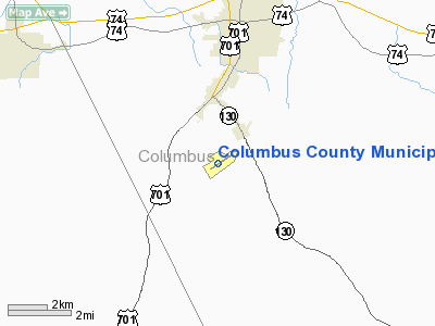
Columbus County, North Carolina |
| Operator |
Whiteville, North Carolina |
| Location |
29.9 |
| Coordinates |
34°16′22″N 078°42′54″W / 34.27278°N 78.715°W / 34.27278; -78.715Coordinates: 34°16′22″N 078°42′54″W / 34.27278°N 78.715°W / 34.27278; -78.715 |
| Runways |
| Direction |
Length |
Surface |
| ft |
m |
| 6/24 |
5,500 |
1,676 |
Asphalt |
Columbus County Municipal Airport (ICAO: KCPC, FAA LID: CPC) is a public airport located three miles (5 km) south of the central business district (CBD) of Whiteville, a city in Columbus County, North Carolina, USA. This general aviation airport covers 166 acres (67 ha) and has one runway.
Although most U.S. airports use the same three-letter location identifier for the FAA and IATA, Columbus County Municipal Airport is assigned CPC by the FAA but has no designation from the IATA (which assigned CPC to Chapelco Airport in San Martin de los Andes, Argentina). The airport's ICAO identifier is KCPC.
The above content comes from Wikipedia and is published under free licenses – click here to read more.
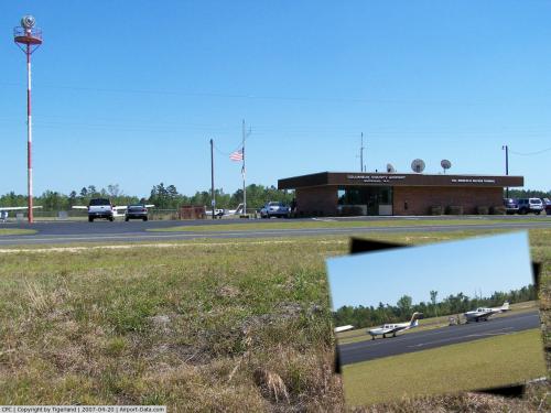 |
(Click on the photo to enlarge) |
Location & QuickFacts
| FAA Information Effective: | 2008-09-25 |
| Airport Identifier: | CPC |
| Airport Status: | Operational |
| Longitude/Latitude: | 078-42-53.9580W/34-16-22.3340N
-78.714988/34.272871 (Estimated) |
| Elevation: | 99 ft / 30.18 m (Surveyed) |
| Land: | 166 acres |
| From nearest city: | 3 nautical miles S of Whiteville, NC |
| Location: | Columbus County, NC |
| Magnetic Variation: | 07W (1985) |
Owner & Manager
| Ownership: | Publicly owned |
| Owner: | Columbus County |
| Address: | 111 Washington St
Whiteville, NC 28472 |
| Phone number: | 910-640-6601 |
| Manager: | Phil Edwards |
| Address: | 467 Airport Road
Whiteville, NC 28472 |
| Phone number: | 910-642-6187 |
Airport Operations and Facilities
| Airport Use: | Open to public |
| Wind indicator: | Yes |
| Segmented Circle: | Yes |
| Control Tower: | No |
| Lighting Schedule: | DUSK-DAWN
AFT 0000 ACTVT MIRL RY 06/24 - CTAF. ACTVT REIL RY 06 & VASI RY 24 - CTAF. |
| Beacon Color: | Clear-Green (lighted land airport) |
| Landing fee charge: | No |
| Sectional chart: | Charlotte |
| Region: | ASO - Southern |
| Boundary ARTCC: | ZJX - Jacksonville |
| Tie-in FSS: | RDU - Raleigh |
| FSS on Airport: | No |
| FSS Toll Free: | 1-800-WX-BRIEF |
| NOTAMs Facility: | CPC (NOTAM-d service avaliable) |
| Federal Agreements: | NGY |
Airport Communications
| CTAF: | 122.800 |
| Unicom: | 122.800 |
Airport Services
| Fuel available: | 100LLA |
| Airframe Repair: | NONE |
| Power Plant Repair: | NONE |
| Bottled Oxygen: | NONE |
| Bulk Oxygen: | NONE |
Runway Information
Runway 06/24
| Dimension: | 5500 x 75 ft / 1676.4 x 22.9 m |
| Surface: | ASPH, Good Condition |
| Weight Limit: | Single wheel: 24000 lbs.
Dual wheel: 30000 lbs. |
| Edge Lights: | Medium |
| |
Runway 06 |
Runway 24 |
| Longitude: | 078-43-18.1660W | 078-42-29.7470W |
| Latitude: | 34-16-04.0030N | 34-16-40.6640N |
| Elevation: | 99.00 ft | 69.00 ft |
| Alignment: | 48 | 127 |
| Traffic Pattern: | Left | Left |
| Markings: | Non-precision instrument, Good Condition | Non-precision instrument, Good Condition |
| Crossing Height: | 40.00 ft | 37.00 ft |
| VASI: | 2-light PAPI on left side | 2-box on left side
VASI OTS INDEFLY. |
| Visual Glide Angle: | 3.00° | 3.00° |
| Runway End Identifier: | Yes | |
| Obstruction: | 46 ft trees, 1948.0 ft from runway, 85 ft left of centerline, 37:1 slope to clear
8 FT BUSHES 100 FT L 100-200 FT FROM THLD. | 52 ft trees, 375.0 ft from runway, 231 ft right of centerline, 3:1 slope to clear |
|
Radio Navigation Aids
| ID |
Type |
Name |
Ch |
Freq |
Var |
Dist |
| TGQ | NDB | Elizabethtown | | 398.00 | 08W | 18.3 nm |
| JB | NDB | Jigel | | 384.00 | 08W | 26.7 nm |
| RSY | NDB | Robeson | | 359.00 | 08W | 26.7 nm |
| MAO | NDB | Marion | | 388.00 | 06W | 31.2 nm |
| HYW | NDB | Horry | | 370.00 | 08W | 34.0 nm |
| DLC | NDB | Dillon | | 274.00 | 05W | 34.1 nm |
| SUT | NDB | Yaupon | | 233.00 | 08W | 38.0 nm |
| CLB | NDB | Carolina Beach | | 216.00 | 04W | 38.8 nm |
| ACZ | NDB | Pendy | | 379.00 | 09W | 44.2 nm |
| ME | NDB | Maxtn | | 257.00 | 08W | 45.5 nm |
| CTZ | NDB | Clinton | | 412.00 | 08W | 45.7 nm |
| LBT | VOR | Lumberton | | 110.00 | 08W | 26.4 nm |
| FAY | VOR/DME | Fayetteville | 025X | 108.80 | 04W | 43.6 nm |
| CRE | VORTAC | Grand Strand | 123X | 117.60 | 03W | 27.6 nm |
| ILM | VORTAC | Wilmington | 117X | 117.00 | 07W | 42.0 nm |
| FLO | VORTAC | Florence | 099X | 115.20 | 03W | 46.9 nm |
Remarks
- USE CARE DEER ON INVOF ARPT.
- 10 FT DITCH AROUND RY PERIMETER 100 FT FROM CNTRLN ON RY LENGTH BOTH SIDES.
- ARPT UNATNDD CHRISTMAS DAY.
- RY 23 HAS 15 FT DROPOFF 200 FT FROM THLD BOTH SIDES.
- VFR OPERATIONS ONLY.
Images and information placed above are from
http://www.airport-data.com/airport/CPC/
We thank them for the data!
| General Info
|
| Country |
United States
|
| State |
NORTH CAROLINA
|
| FAA ID |
CPC
|
| Latitude |
34-16-22.342N
|
| Longitude |
078-42-53.974W
|
| Elevation |
98 feet
|
| Near City |
WHITEVILLE
|
We don't guarantee the information is fresh and accurate. The data may
be wrong or outdated.
For more up-to-date information please refer to other sources.
|
|


