 |
|
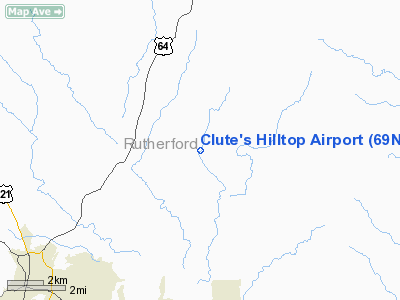
Location & QuickFacts
| FAA Information Effective: | 2008-09-25 |
| Airport Identifier: | 69NC |
| Airport Status: | Operational |
| Longitude/Latitude: | 081-51-04.3630W/35-26-02.4460N
-81.851212/35.434013 (Estimated) |
| Elevation: | 1078 ft / 328.57 m (Surveyed) |
| Land: | 10 acres |
| From nearest city: | 6 nautical miles N of Forest City, NC |
| Location: | Rutherford County, NC |
| Magnetic Variation: | 04W (1985) |
Owner & Manager
| Ownership: | Privately owned |
| Owner: | Charles Clute |
| Address: | 4177 Whitesides Rd
Bostic, NC 28018-6736 |
| Phone number: | 828-287-9224 |
| Manager: | Charles Clute |
| Address: | 4181 Whitesides Road
Bostic, NC 28018-6736 |
| Phone number: | 828-287-9224 |
Airport Operations and Facilities
| Airport Use: | Private |
| Wind indicator: | Yes |
| Segmented Circle: | No |
| Control Tower: | No |
| Landing fee charge: | No |
| Sectional chart: | Atlanta |
| Region: | ASO - Southern |
| Boundary ARTCC: | ZTL - Atlanta |
| Tie-in FSS: | RDU - Raleigh |
| FSS on Airport: | No |
| FSS Toll Free: | 1-800-WX-BRIEF |
Airport Services
| Airframe Repair: | NONE |
| Power Plant Repair: | NONE |
Runway Information
Runway 08/26
| Dimension: | 2200 x 120 ft / 670.6 x 36.6 m |
| Surface: | TURF, |
| |
Runway 08 |
Runway 26 |
| Traffic Pattern: | Left | Left |
| Obstruction: | , 50:1 slope to clear | 15 ft road, 0.0 ft from runway |
|
Radio Navigation Aids
| ID |
Type |
Name |
Ch |
Freq |
Var |
Dist |
| MRN | FAN MARKER | Lenoir | | | 03W | 24.4 nm |
| RFE | NDB | Rutherford | | 344.00 | 05W | 7.1 nm |
| SLP | NDB | First River | | 417.00 | 06W | 16.5 nm |
| FIQ | NDB | Fiddlers | | 391.00 | 07W | 18.8 nm |
| BRA | NDB | Broad River | | 379.00 | 04W | 31.9 nm |
| FRT | NDB | Fairmont | | 248.00 | 05W | 32.6 nm |
| HK | NDB | Tawba | | 332.00 | 06W | 34.1 nm |
| GHJ | NDB | Stonia | | 260.00 | 06W | 37.0 nm |
| IZN | NDB | Lincolnton | | 432.00 | 06W | 37.9 nm |
| BAR | NDB | Hemlock | | 320.00 | 02W | 43.3 nm |
| VW | NDB | Temky | | 280.00 | 05W | 43.5 nm |
| UOT | NDB | Union County | | 326.00 | 04W | 46.2 nm |
| BZM | VOR/DME | Barretts Mountain | 045X | 110.80 | 06W | 39.7 nm |
| CLT | VOR/DME | Charlotte | 097X | 115.00 | 05W | 46.5 nm |
| SUG | VORTAC | Sugarloaf Mountain | 059X | 112.20 | 02W | 20.5 nm |
| SPA | VORTAC | Spartanburg | 104X | 115.70 | 02W | 24.4 nm |
| HKY | VOT | Hickory Regional | | 110.00 | | 29.1 nm |
| CLT | VOT | Charlotte | | 112.00 | | 46.7 nm |
Remarks
- AEROBATIC PRACTICE BOX LCTD OVER RY 08/26 EXTENDING 3000 FT NORTH; 4500 FT MSL & BLO. CTC GREER APCH CTL FOR INFO.
- VFR OPERATIONS ONLY.
Images and information placed above are from
http://www.airport-data.com/airport/69NC/
We thank them for the data!
| General Info
|
| Country |
United States
|
| State |
NORTH CAROLINA
|
| FAA ID |
69NC
|
| Latitude |
35-26-02.446N
|
| Longitude |
081-51-04.363W
|
| Elevation |
1078 feet
|
| Near City |
FOREST CITY
|
We don't guarantee the information is fresh and accurate. The data may
be wrong or outdated.
For more up-to-date information please refer to other sources.
|
|


