|
 |
|
||||
|
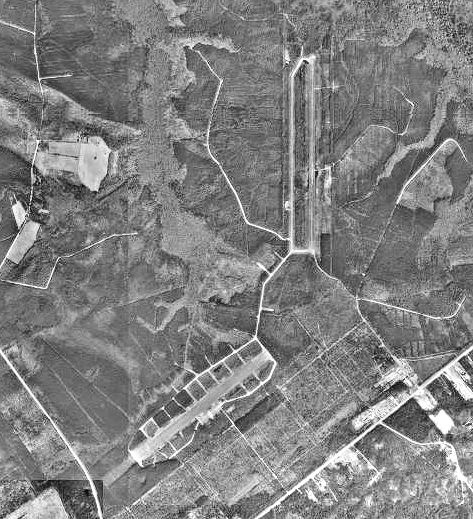
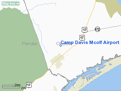
Marine Corps Outlying Field (MCOLF) Camp Davis (FAA LID: 14NC) is a military use airport located 1 nautical mile (1.9 km) southeast of the central business district of Holly Ridge, in Onslow County, North Carolina, United States. It is used a training facility by the United States Marines of Camp Lejeune and MCAS New River. HistoryIn late December 1940, Camp Davis was built by the United States Army as an antiaircraft artillery training facility. Manned by about 20,000 officers and men, Camp Davis was attached to the First Army, Fourth Corps Area. It was an expansive facility consisting of more than 3,000 buildings on 45,538 acres (184 km) with access provided by newly-built railroad spurs leading into the camp. Between 1942-43, two 5,000 feet (1,500 m) paved runways were built for Camp Davis Army Air Field (AAF). Part of the runway for the airfield was built through one of the old Civil War fort's walls. Camp Davis AAF's Runway 5/23 was wider, and was intended for use by transports, while Runway 19/01 was narrower and intended for use by single-engine aircraft. Most of the aircraft operated from Camp Davis runways were single-engine aircraft used to tow targets for the anti-aircraft artillery units. In 1944 the anti-aircraft training facility was transferred to another base, and on February 17, 1946, Camp Davis was closed. Circa June 1, 1946, a portion of the Camp Davis area formerly used by the Army as the Coastal Artillery Anti-Aircraft Firing Range (present-day Surf City, North Carolina) was transferred to the United States Navy. The Navy temporarily used the site for the development and testing of early surface-to-air missiles under the name Operation Bumblebee until July 28, 1948. Camp Davis was declared surplus and was dismantled for salvage and sale. At that time, the Navy apparently gave up the leases on the land and it was returned to the original landowners. In 1954, the Marine Corps took out a new lease for approximately 955 acres (3.86 km) on the former Camp Davis airfields & surrounding land from International Paper Company. In recent years, the Marine Corps has used Camp Davis as a satellite airfield for helicopter units based at the nearby New River airstation. Runway 18/36 was resurfaced with concrete in 1997, possibly for use by V-22 Ospreys. FacilitiesMCOLF Camp Davis has two runways which are designated 5/23 and 18/36. Both runways have concrete surfaces measuring 5000 by 150 feet. The older runway 5/23 is not currently in use, while newer runway 18/36 is using for helicopter assault landing exercises. The above content comes from Wikipedia and is published under free licenses – click here to read more.
Location & QuickFacts
Owner & Manager
Airport Operations and Facilities
Airport Communications
Runway InformationRunway 05/23
Runway 18/36
Radio Navigation Aids
Images and information placed above are from We thank them for the data!
We don't guarantee the information is fresh and accurate. The data may
be wrong or outdated.
|
|||||||||||||||||||||||||||||||||||||||||||||||||||||||||||||||||||||||||||||||||||||||||||||||||||||||||||||||||||||||||||||||||||||||||||||||||||||||||||||||||||||||||||||||||||||||||||||||||||||||||||||||||||||||||||||||||||||||||||||||||||||||||||||||||||||||||||||||||||||||||||||||||||||

 |
|
Copyright 2004-2026 © by Airports-Worldwide.com, Vyshenskoho st. 36, Lviv 79010, Ukraine Legal Disclaimer |