 |
|
| Bradford Field |
| IATA: none – ICAO: none – FAA LID: NC05 |
| Summary |
| Airport type |
Private |
| Owner |
W. O. & Cecil D. Bradford |
| Location |
Huntersville, North Carolina |
| Elevation AMSL |
649 ft / 198 m |
| Coordinates |
35°24′32″N 080°47′39″W / 35.40889°N 80.79417°W / 35.40889; -80.79417 |
| Runways |
| Direction |
Length |
Surface |
| ft |
m |
| 6/24 |
3,850 |
1,173 |
Turf |
| Statistics |
| Aircraft operations |
9,400 |
| Based aircraft |
64 |
| Source: Federal Aviation Administration |
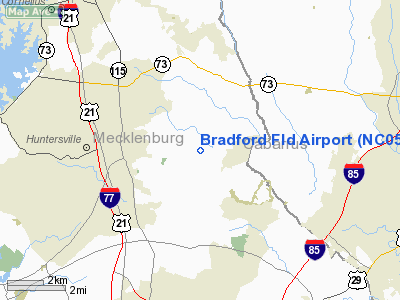
Bradford Field (FAA LID: NC05) is a private-use airport located three miles (5 km) east of the central business district of Huntersville, a town in Mecklenburg County, North Carolina, United States. It is privately owned by W. O. & Cecil D. Bradford.
Facilities and aircraft
Bradford Field has one runway (6/24) with a turf surface measuring 3,850 x 150 ft. (1,173 x 46 m). For a 12-month period (date unknown), the airport had 9,400 general aviation aircraft operations, an average of 25 per day. There are 64 single-engine aircraft based at this airport.
The above content comes from Wikipedia and is published under free licenses – click here to read more.
Location & QuickFacts
| FAA Information Effective: | 2008-09-25 |
| Airport Identifier: | NC05 |
| Airport Status: | Operational |
| Longitude/Latitude: | 080-47-39.2570W/35-24-31.5000N
-80.794238/35.408750 (Estimated) |
| Elevation: | 649 ft / 197.82 m (Estimated) |
| Land: | 0 acres |
| From nearest city: | 3 nautical miles E of Huntersville, NC |
| Location: | Mecklenburg County, NC |
| Magnetic Variation: | 05W (1985) |
Owner & Manager
| Ownership: | Privately owned |
| Owner: | W. O. & Cecil D. Bradford |
| Address: | Po Box 1727
Huntersville, NC 28070 |
| Phone number: | 704-578-4039 |
| Manager: | Steve Yancey |
| Address: | 14100 Sims Road
Huntersville, NC 28078 |
| Phone number: | 704-305-2927 |
Airport Operations and Facilities
| Airport Use: | Private |
| Wind indicator: | Yes |
| Segmented Circle: | Yes |
| Control Tower: | No |
| Landing fee charge: | No |
| Sectional chart: | Charlotte |
| Region: | ASO - Southern |
| Boundary ARTCC: | ZTL - Atlanta |
| Tie-in FSS: | RDU - Raleigh |
| FSS on Airport: | No |
| FSS Toll Free: | 1-800-WX-BRIEF |
Airport Services
| Fuel available: | 100 80 |
| Airframe Repair: | NONE |
| Power Plant Repair: | NONE |
Runway Information
Runway 06/24
| Dimension: | 3850 x 150 ft / 1173.5 x 45.7 m |
| Surface: | TURF, |
| |
Runway 06 |
Runway 24 |
| Traffic Pattern: | Left | Right |
| Runway End Identifier: | No | No |
| Centerline Lights: | No | No |
| Touchdown Lights: | No | No |
| Obstruction: | | 25 ft pline, 400.0 ft from runway, 10:1 slope to clear |
|
Radio Navigation Aids
| ID |
Type |
Name |
Ch |
Freq |
Var |
Dist |
| MRN | FAN MARKER | Lenoir | | | 03W | 46.8 nm |
| IZN | NDB | Lincolnton | | 432.00 | 06W | 16.3 nm |
| GHJ | NDB | Stonia | | 260.00 | 06W | 22.1 nm |
| RU | NDB | Rovdy | | 275.00 | 06W | 24.5 nm |
| VW | NDB | Temky | | 280.00 | 05W | 25.7 nm |
| TWL | NDB | Wesley | | 204.00 | 06W | 27.7 nm |
| SEN | NDB | Swearing/dcmsnd | | 260.00 | 06W | 33.0 nm |
| HK | NDB | Tawba | | 332.00 | 06W | 33.8 nm |
| UZ | NDB | Rally | | 227.00 | 05W | 34.2 nm |
| DVZ | NDB | Davie | | 354.00 | 06W | 34.5 nm |
| VU | NDB | Aller | | 346.00 | 06W | 35.3 nm |
| SLP | NDB | First River | | 417.00 | 06W | 40.6 nm |
| LKR | NDB | Lancaster | | 400.00 | 07W | 41.3 nm |
| AFP | NDB | Anson County | | 283.00 | 07W | 41.9 nm |
| DCM | NDB | Chester | | 220.00 | 06W | 42.4 nm |
| UKF | NDB | Wilki | | 209.00 | 06W | 44.8 nm |
| PYG | NDB | Pageland | | 270.00 | 06W | 45.8 nm |
| FIQ | NDB | Fiddlers | | 391.00 | 07W | 46.6 nm |
| CQJ | NDB | City Lake | | 266.00 | 08W | 49.0 nm |
| CLT | VOR/DME | Charlotte | 097X | 115.00 | 05W | 15.2 nm |
| BZM | VOR/DME | Barretts Mountain | 045X | 110.80 | 06W | 35.2 nm |
| FML | VORTAC | Fort Mill | 071X | 112.40 | 02W | 26.4 nm |
| CLT | VOT | Charlotte | | 112.00 | | 13.6 nm |
| HKY | VOT | Hickory Regional | | 110.00 | | 35.3 nm |
Remarks
Images and information placed above are from
http://www.airport-data.com/airport/NC05/
We thank them for the data!
| General Info
|
| Country |
United States
|
| State |
NORTH CAROLINA
|
| FAA ID |
NC05
|
| Latitude |
35-24-31.500N
|
| Longitude |
080-47-39.257W
|
| Elevation |
649 feet
|
| Near City |
HUNTERSVILLE
|
We don't guarantee the information is fresh and accurate. The data may
be wrong or outdated.
For more up-to-date information please refer to other sources.
|
|


