 |
|
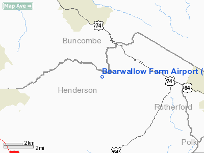
Location & QuickFacts
| FAA Information Effective: | 2008-09-25 |
| Airport Identifier: | 0NC1 |
| Airport Status: | Operational |
| Longitude/Latitude: | 082-22-31.4200W/35-27-25.4210N
-82.375394/35.457061 (Estimated) |
| Elevation: | 3608 ft / 1099.72 m (Estimated) |
| Land: | 0 acres |
| From nearest city: | 10 nautical miles NE of Hendersonville, NC |
| Location: | Henderson County, NC |
| Magnetic Variation: | 04W (1985) |
Owner & Manager
| Ownership: | Privately owned |
| Owner: | Rivendell Farm Ltd |
| Address: | C/o Cnl Group Inc, 450 South Orange Ave
Orlando, FL 32801 |
| Phone number: | 407-650-1000 |
| Manager: | Karen Schlacter |
| Address: | C/o Cnl Group Inc, 450 South Orange Ave
Orlando, FL 32801 |
| Phone number: | 407-650-1251 |
Airport Operations and Facilities
| Airport Use: | Private |
| Wind indicator: | Yes |
| Segmented Circle: | No |
| Control Tower: | No |
| Landing fee charge: | No |
| Sectional chart: | Atlanta |
| Region: | ASO - Southern |
| Boundary ARTCC: | ZTL - Atlanta |
| Tie-in FSS: | RDU - Raleigh |
| FSS on Airport: | No |
| FSS Toll Free: | 1-800-WX-BRIEF |
Runway Information
Runway 04/22
| Dimension: | 1460 x 60 ft / 445.0 x 18.3 m |
| Surface: | TURF, |
| |
Runway 04 |
Runway 22 |
| Traffic Pattern: | Left | Left |
|
Radio Navigation Aids
| ID |
Type |
Name |
Ch |
Freq |
Var |
Dist |
| MRN | FAN MARKER | Lenoir | | | 03W | 42.0 nm |
| BRA | NDB | Broad River | | 379.00 | 04W | 12.0 nm |
| RFE | NDB | Rutherford | | 344.00 | 05W | 21.7 nm |
| FIQ | NDB | Fiddlers | | 391.00 | 07W | 37.6 nm |
| FRT | NDB | Fairmont | | 248.00 | 05W | 38.5 nm |
| SLP | NDB | First River | | 417.00 | 06W | 40.0 nm |
| LQK | NDB | Lake Keowee | | 408.00 | 04W | 42.0 nm |
| GY | NDB | Dyana | | 338.00 | 03W | 46.2 nm |
| DYQ | NDB | Dulaney | | 263.00 | 04W | 47.9 nm |
| BAR | NDB | Hemlock | | 320.00 | 02W | 48.3 nm |
| SUG | VORTAC | Sugarloaf Mountain | 059X | 112.20 | 02W | 6.0 nm |
| SPA | VORTAC | Spartanburg | 104X | 115.70 | 02W | 33.6 nm |
| SOT | VORTAC | Snowbird | 025X | 108.80 | 04W | 38.7 nm |
Remarks
- ALL OPNS ARE CONDUCTED IN VFR WX CONDS; LNDG AREA IS LMTD TO PVT USE; A WRITTEN OPNL AGRMT IS MAINTD WITH THE ASHEVILLE ATCT.
Images and information placed above are from
http://www.airport-data.com/airport/0NC1/
We thank them for the data!
| General Info
|
| Country |
United States
|
| State |
NORTH CAROLINA
|
| FAA ID |
0NC1
|
| Latitude |
35-27-25.421N
|
| Longitude |
082-22-31.420W
|
| Elevation |
3608 feet
|
| Near City |
HENDERSONVILLE
|
We don't guarantee the information is fresh and accurate. The data may
be wrong or outdated.
For more up-to-date information please refer to other sources.
|
|


