 |
|
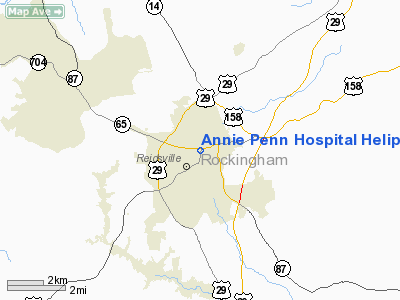
Annie Penn Hospital Heliport |
Location & QuickFacts
| FAA Information Effective: | 2008-09-25 |
| Airport Identifier: | 38NC |
| Airport Status: | Operational |
| Longitude/Latitude: | 079-40-00.0000W/36-21-14.0000N
-79.666667/36.353889 (Estimated) |
| Elevation: | 816 ft / 248.72 m (Estimated) |
| Land: | 0 acres |
| From nearest city: | 0 nautical miles N of Reidsville, NC |
| Location: | Rockingham County, NC |
| Magnetic Variation: | 07W (1995) |
Owner & Manager
| Ownership: | Privately owned |
| Owner: | Annie Penn Hospital |
| Address: | 618 South Main Street
Reidsville, NC 27320 |
| Phone number: | 336-634-1010 |
| Manager: | Hospital Administrator |
| Address: | 618 South Main Street
Reidsville, NC 27320 |
| Phone number: | 336-634-4582 |
Airport Operations and Facilities
| Airport Use: | Private
MEDICAL USE. |
| Wind indicator: | Yes |
| Segmented Circle: | No |
| Control Tower: | No |
| Lighting Schedule: | PHONE REQ
FOR PERIMETER LGTS CALL 336-634-1010. |
| Sectional chart: | Cincinnati |
| Region: | ASO - Southern |
| Boundary ARTCC: | ZDC - Washington |
| Tie-in FSS: | RDU - Raleigh |
| FSS on Airport: | No |
| FSS Toll Free: | 1-800-WX-BRIEF |
Runway Information
Helipad H1
| Dimension: | 45 x 45 ft / 13.7 x 13.7 m |
| Surface: | CONC, |
| |
Runway H1 |
Runway |
| Traffic Pattern: | Left | Left |
|
Radio Navigation Aids
| ID |
Type |
Name |
Ch |
Freq |
Var |
Dist |
| OQA | FAN MARKER | Rockingham County | | | | 9.0 nm |
| SIF | NDB | Slammer | | 423.00 | 07W | 5.0 nm |
| UV | NDB | Bales | | 396.00 | 07W | 18.7 nm |
| HB | NDB | Himun | | 361.00 | 08W | 22.9 nm |
| HUR | NDB | Person | | 220.00 | 08W | 30.0 nm |
| TOX | NDB | Siler City | | 371.00 | 07W | 37.0 nm |
| CQJ | NDB | City Lake | | 266.00 | 08W | 39.5 nm |
| AZW | NDB | Mount Airy | | 223.00 | 07W | 42.3 nm |
| SEN | NDB | Swearing/dcmsnd | | 260.00 | 06W | 46.2 nm |
| DVZ | NDB | Davie | | 354.00 | 06W | 46.6 nm |
| DAN | VOR | Danville | | 113.10 | 06W | 20.5 nm |
| GSO | VORTAC | Greensboro | 109X | 116.20 | 03W | 23.9 nm |
| LIB | VORTAC | Liberty | 077X | 113.00 | 03W | 32.7 nm |
| SBV | VORTAC | South Boston | 041X | 110.40 | 05W | 36.9 nm |
Remarks
- PRVDD VFR/PVT USE; AREA IS MKD; WIND INDICATOR IS MAINTAINED.
Images and information placed above are from
http://www.airport-data.com/airport/38NC/
We thank them for the data!
| General Info
|
| Country |
United States
|
| State |
NORTH CAROLINA
|
| FAA ID |
38NC
|
| Latitude |
36-21-14.000N
|
| Longitude |
079-40-00.000W
|
| Elevation |
816 feet
|
| Near City |
REIDSVILLE
|
We don't guarantee the information is fresh and accurate. The data may
be wrong or outdated.
For more up-to-date information please refer to other sources.
|
|


