 |
|
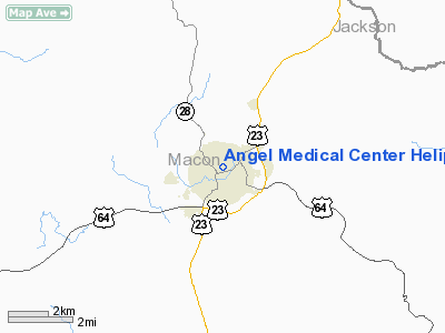
Angel Medical Center Heliport |
Location & QuickFacts
| FAA Information Effective: | 2008-09-25 |
| Airport Identifier: | 93NC |
| Airport Status: | Operational |
| Longitude/Latitude: | 083-22-48.1300W/35-11-04.3700N
-83.380036/35.184547 (Estimated) |
| Elevation: | 2086 ft / 635.81 m (Estimated) |
| Land: | 0 acres |
| From nearest city: | 0 nautical miles of Franklin, NC |
| Location: | Macon County, NC |
| Magnetic Variation: | () |
Owner & Manager
| Ownership: | Privately owned |
| Owner: | Angel Medical Center |
| Address: | Po Box 1209
Franklin, NC 28744 |
| Phone number: | 828-524-8411 |
| Manager: | Tom Cowan |
| Address: | 509 Biltmore Ave
Asheville, NC 28801 |
| Phone number: | 828-213-0912 |
Airport Operations and Facilities
| Airport Use: | Private |
| Control Tower: | No |
| Sectional chart: | Atlanta |
| Region: | ASO - Southern |
| Boundary ARTCC: | ZTL - Atlanta |
| Tie-in FSS: | RDU - Raleigh |
| FSS Toll Free: | 1-800-WX-BRIEF |
Runway Information
Helipad H1
| Dimension: | 50 x 50 ft / 15.2 x 15.2 m |
| Surface: | CONC, |
| |
Runway H1 |
Runway |
| Traffic Pattern: | Left | Left |
|
Radio Navigation Aids
| ID |
Type |
Name |
Ch |
Freq |
Var |
Dist |
| TTQ | NDB | Tomotla | | 335.00 | 01W | 28.6 nm |
| CEU | NDB | Clemson | | 257.00 | 05W | 39.2 nm |
| LQK | NDB | Lake Keowee | | 408.00 | 04W | 40.2 nm |
| AJR | NDB | Habersham | | 347.00 | 03W | 41.9 nm |
| BRA | NDB | Broad River | | 379.00 | 04W | 44.9 nm |
| ODF | VORTAC | Foothills | 081X | 113.40 | 00E | 29.7 nm |
| HRS | VORTAC | Harris | 035X | 109.80 | 00E | 30.1 nm |
| SOT | VORTAC | Snowbird | 025X | 108.80 | 04W | 39.8 nm |
| TYS | VOT | Knoxville | | 112.00 | | 48.2 nm |
Images and information placed above are from
http://www.airport-data.com/airport/93NC/
We thank them for the data!
|
|


