 |
|
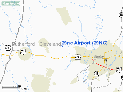
Location & QuickFacts
| FAA Information Effective: | 2008-09-25 |
| Airport Identifier: | 29NC |
| Airport Status: | Operational |
| Longitude/Latitude: | 081-37-31.0000W/35-18-42.0000N
-81.625278/35.311667 (Estimated) |
| Elevation: | 930 ft / 283.46 m (Estimated) |
| Land: | 46 acres |
| From nearest city: | 1 nautical miles N of Shelby, NC |
| Location: | Cleveland County, NC |
| Magnetic Variation: | 05W () |
Owner & Manager
| Ownership: | Privately owned |
| Owner: | Jerry & Carolyn Self |
| Address: | 3662 Artee Road
Shelby, NC 28150-7760 |
| Phone number: | 704-434-7435 |
| Manager: | Jerry L. Self |
| Address: | 3662 Artee Road
Shelby, NC 28150-7760 |
| Phone number: | 704-434-7435 |
Airport Operations and Facilities
| Airport Use: | Private |
| Wind indicator: | Yes |
| Segmented Circle: | No |
| Control Tower: | No |
| Sectional chart: | Atlanta |
| Region: | ASO - Southern |
| Boundary ARTCC: | ZTL - Atlanta |
| Tie-in FSS: | RDU - Raleigh |
| FSS Toll Free: | 1-800-WX-BRIEF |
Runway Information
Runway 07/25
| Dimension: | 1843 x 50 ft / 561.7 x 15.2 m |
| Surface: | TURF, Good Condition |
| |
Runway 07 |
Runway 25 |
| Traffic Pattern: | Left | Right |
| Obstruction: | | 50 ft bldg, 375.0 ft from runway |
|
Radio Navigation Aids
| ID |
Type |
Name |
Ch |
Freq |
Var |
Dist |
| MRN | FAN MARKER | Lenoir | | | 03W | 29.1 nm |
| SLP | NDB | First River | | 417.00 | 06W | 3.8 nm |
| RFE | NDB | Rutherford | | 344.00 | 05W | 16.2 nm |
| FIQ | NDB | Fiddlers | | 391.00 | 07W | 24.1 nm |
| GHJ | NDB | Stonia | | 260.00 | 06W | 24.1 nm |
| IZN | NDB | Lincolnton | | 432.00 | 06W | 29.7 nm |
| FRT | NDB | Fairmont | | 248.00 | 05W | 30.3 nm |
| HK | NDB | Tawba | | 332.00 | 06W | 32.5 nm |
| UZ | NDB | Rally | | 227.00 | 05W | 36.9 nm |
| UOT | NDB | Union County | | 326.00 | 04W | 37.7 nm |
| DCM | NDB | Chester | | 220.00 | 06W | 37.8 nm |
| VW | NDB | Temky | | 280.00 | 05W | 39.1 nm |
| BRA | NDB | Broad River | | 379.00 | 04W | 41.6 nm |
| CLT | VOR/DME | Charlotte | 097X | 115.00 | 05W | 33.9 nm |
| BZM | VOR/DME | Barretts Mountain | 045X | 110.80 | 06W | 38.4 nm |
| SPA | VORTAC | Spartanburg | 104X | 115.70 | 02W | 22.3 nm |
| SUG | VORTAC | Sugarloaf Mountain | 059X | 112.20 | 02W | 32.0 nm |
| FML | VORTAC | Fort Mill | 071X | 112.40 | 02W | 38.2 nm |
| HKY | VOT | Hickory Regional | | 110.00 | | 28.2 nm |
| CLT | VOT | Charlotte | | 112.00 | | 34.2 nm |
Remarks
- ALL TFC PATS CONDUCTED NORTHWEST OF ARPT.
- RCMD LNDG RY 07, TKOF RY 25.
- 7 FT FENCE 24 FT FM RY 25 THLD.
- PRVDD VFR/PVT USE, AFF TFC PATS ARE CONDUCTED NORTHWEST OF ARPT.
Images and information placed above are from
http://www.airport-data.com/airport/29NC/
We thank them for the data!
| General Info
|
| Country |
United States
|
| State |
NORTH CAROLINA
|
| FAA ID |
29NC
|
| Latitude |
35-18-42.000N
|
| Longitude |
081-37-31.000W
|
| Elevation |
930 feet
|
| Near City |
LATTIMORE
|
We don't guarantee the information is fresh and accurate. The data may
be wrong or outdated.
For more up-to-date information please refer to other sources.
|
|


