 |
|
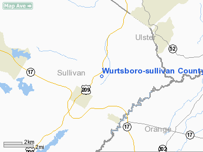
Wurtsboro-sullivan County Airport |
| Wurtsboro-Sullivan County Airport |
| IATA: none – ICAO: none – FAA LID: N82 |
| Summary |
| Airport type |
Public |
| Owner |
Shalom Lamm |
| Serves |
Wurtsboro, New York |
| Location |
Mamakating, New York |
| Elevation AMSL |
560 ft / 171 m |
| Coordinates |
41°35′50″N 074°27′30″W / 41.59722°N 74.45833°W / 41.59722; -74.45833 |
| Website |
WurtsboroAirport.com |
| Runways |
| Direction |
Length |
Surface |
| ft |
m |
| 5/23 |
3,592 |
1,095 |
Asphalt |
| 9/27 |
1,100 |
335 |
Turf |
| 14/32 |
2,101 |
640 |
Turf |
| 18/36 |
1,250 |
381 |
Turf |
| Statistics (2007) |
| Aircraft operations |
70,000 |
| Based aircraft |
97 |
| Sources: FAA, airport website |
Wurtsboro-Sullivan County Airport (FAA LID: N82) is a privately-owned, public-use airport located two nautical miles (4 km) northeast of the central business district of Wurtsboro, in Sullivan County, New York, United States. It is privately owned by Shalom Lamm. It is commonly called Wurtsboro Airport.
It is believed to be the oldest operating glider airport in the nation. The airport is located along Route 209 and the D & H Canal in the town of Mamakating.
Facilities and aircraft
Wurtsboro Airport covers an area of 500 acres (202 ha) which contains four unlit runways:
- Runway 5/23: 3592 x 60 ft (1095 x 18 m), Surface: Asphalt
- Runway 14/32: 2101 x 120 ft (640 x 37 m), Surface: Turf
- Runway 18/36: 1250 x 150 ft (381 x 46 m), Surface: Turf
- Runway 9/27: 1100 x 110 ft (335 x 34 m), Surface: Turf
Services available:
- Glider and Power Rides, Instruction, Rental, Sales and Tow.
- Hangars and Tiedowns.
- Attended 0900 - 1700.
There are 97 aircraft based at this airport: 52 single-engine and 45 gliders.
The above content comes from Wikipedia and is published under free licenses – click here to read more.
Location & QuickFacts
| FAA Information Effective: | 2008-09-25 |
| Airport Identifier: | N82 |
| Airport Status: | Operational |
| Longitude/Latitude: | 074-27-30.0000W/41-35-49.7000N
-74.458333/41.597139 (Estimated) |
| Elevation: | 560 ft / 170.69 m (Estimated) |
| Land: | 500 acres |
| From nearest city: | 2 nautical miles NE of Wurtsboro, NY |
| Location: | Sullivan County, NY |
| Magnetic Variation: | 12W (1975) |
Owner & Manager
| Ownership: | Privately owned |
| Owner: | Shalom Lamm |
| Address: | Wurtsboro Airport, Route 209, P.o. Box 129
Wurtsboro, NY 12790 |
| Phone number: | 845-888-2791 |
| Manager: | Dan Depew |
| Address: | Wurtsboro Airport, Route 209, P.o. Box 129
Wurtsboro, NY 12790 |
| Phone number: | 914-888-2791 |
Airport Operations and Facilities
| Airport Use: | Open to public |
| Wind indicator: | Yes |
| Segmented Circle: | No |
| Control Tower: | No |
| Landing fee charge: | No |
| Sectional chart: | New York |
| Region: | AEA - Eastern |
| Boundary ARTCC: | ZBW - Boston |
| Responsible ARTCC: | ZNY - New York |
| Tie-in FSS: | ISP - New York |
| FSS on Airport: | No |
| FSS Toll Free: | 1-800-WX-BRIEF |
| NOTAMs Facility: | ISP (NOTAM-d service avaliable) |
| Federal Agreements: | N |
Airport Communications
| CTAF: | 122.800 |
| Unicom: | 122.800 |
Airport Services
| Bottled Oxygen: | NONE |
| Bulk Oxygen: | NONE |
Runway Information
Runway 05/23
| Dimension: | 3592 x 60 ft / 1094.8 x 18.3 m |
| Surface: | ASPH, Good Condition |
| Weight Limit: | Single wheel: 30000 lbs. |
| |
Runway 05 |
Runway 23 |
| Longitude: | 074-27-49.2249W | 074-27-21.5983W |
| Latitude: | 41-35-37.3075N | 41-36-06.0995N |
| Elevation: | 548.00 ft | 537.00 ft |
| Alignment: | 36 | 127 |
| Traffic Pattern: | Left | Left |
| Markings: | Non-precision instrument, Fair Condition
RY 05/23 MKGS RUST STAINED. | Non-precision instrument, Fair Condition |
| Displaced threshold: | 233.00 ft | 0.00 ft |
| Obstruction: | 14 ft pole, 400.0 ft from runway, 14:1 slope to clear
APCH RATIO 35:1 TO DSPLCD THLD.
+8 FT BERM 50 FT FM THLD; 0B. | 10 ft brush, 201.0 ft from runway, 50 ft left of centerline
RY 23, +13 FT TREE, 68 FT FROM RWY BEG, 49 FT LEFT. |
|
Runway 09/27
| Dimension: | 1100 x 110 ft / 335.3 x 33.5 m |
| Surface: | TURF, Fair Condition |
| |
Runway 09 |
Runway 27 |
| Longitude: | 074-27-32.1195W | 074-27-17.9684W |
| Latitude: | 41-35-53.7336N | 41-35-56.0430N |
| Elevation: | 542.00 ft | 534.00 ft |
| Alignment: | 78 | 127 |
| Traffic Pattern: | Left | Left |
| Obstruction: | 61 ft tree, 561.0 ft from runway, 9:1 slope to clear | 48 ft trees, 100.0 ft from runway, 111 ft left of centerline, 2:1 slope to clear |
|
Runway 14/32
| Dimension: | 2101 x 120 ft / 640.4 x 36.6 m |
| Surface: | TURF, Fair Condition |
| |
Runway 14 |
Runway 32 |
| Longitude: | 074-27-33.5813W | 074-27-11.7335W |
| Latitude: | 41-35-53.1111N | 41-35-40.3870N |
| Elevation: | 543.00 ft | 532.00 ft |
| Alignment: | 127 | 127 |
| Traffic Pattern: | Left | Left |
| Obstruction: | 210 ft ridge, 1400.0 ft from runway, 6:1 slope to clear | 112 ft trees, 102.0 ft from runway, 122 ft right of centerline |
|
Runway 18/36
| Dimension: | 1250 x 150 ft / 381.0 x 45.7 m |
| Surface: | TURF, Fair Condition |
| |
Runway 18 |
Runway 36 |
| Longitude: | 074-27-31.6089W | 074-27-30.1097W |
| Latitude: | 41-35-50.7010N | 41-35-38.4008N |
| Elevation: | 539.00 ft | 536.00 ft |
| Alignment: | 127 | 127 |
| Traffic Pattern: | Left | Left |
| Obstruction: | 200 ft ridge, 1110.0 ft from runway, 5:1 slope to clear | 76 ft trees, 55.0 ft from runway, 103 ft right of centerline |
|
Radio Navigation Aids
| ID |
Type |
Name |
Ch |
Freq |
Var |
Dist |
| SKU | FAN MARKER | Stanwyck | | | 12W | 19.0 nm |
| SW | NDB | Neely | | 335.00 | 14W | 12.3 nm |
| SKU | NDB | Stanwyck | | 261.00 | 12W | 19.0 nm |
| MS | NDB | Monga | | 359.00 | 12W | 20.7 nm |
| PO | NDB | Meier | | 403.00 | 12W | 22.2 nm |
| PNJ | NDB | Paterson | | 347.00 | 12W | 41.5 nm |
| HUO | VOR/DME | Huguenot | 108X | 116.10 | 11W | 12.8 nm |
| IGN | VOR/DME | Kingston | 123X | 117.60 | 12W | 28.9 nm |
| PWL | VOR/DME | Pawling | 090X | 114.30 | 12W | 39.9 nm |
| STW | VOR/DME | Stillwater | 033X | 109.60 | 11W | 40.6 nm |
| DNY | VOR/DME | De Lancey | 058X | 112.10 | 11W | 41.4 nm |
| CMK | VOR/DME | Carmel | 113X | 116.60 | 12W | 43.9 nm |
| HNK | VOR/DME | Hancock | 115X | 116.80 | 11W | 47.5 nm |
| TEB | VOR/DME | Teterboro | 021X | 108.40 | 11W | 48.4 nm |
| SAX | VORTAC | Sparta | 104X | 115.70 | 11W | 32.0 nm |
| LHY | VORTAC | Lake Henry | 045X | 110.80 | 10W | 46.7 nm |
Remarks
- DEER ON & INVOF ARPT.
- EXTSV GLIDER ACTIVITY.
- +86 FT TREE 120 FT OUT AND 150 FT RIGHT OF RY 23 CENTERLINE.
Images and information placed above are from
http://www.airport-data.com/airport/N82/
We thank them for the data!
| General Info
|
| Country |
United States
|
| State |
NEW YORK
|
| FAA ID |
N82
|
| Latitude |
41-35-49.936N
|
| Longitude |
074-27-30.266W
|
| Elevation |
560 feet
|
| Near City |
WURTSBORO
|
We don't guarantee the information is fresh and accurate. The data may
be wrong or outdated.
For more up-to-date information please refer to other sources.
|
|


