 |
|
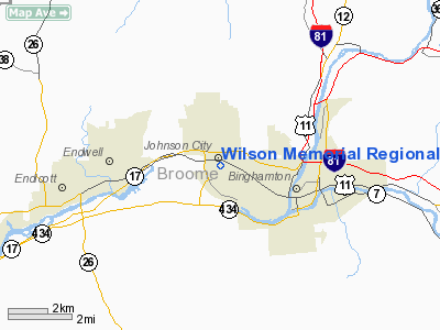
Wilson Memorial Rgnl Medical Center Heliport |
Location & QuickFacts
| FAA Information Effective: | 2008-09-25 |
| Airport Identifier: | 9NY1 |
| Airport Status: | Operational |
| Longitude/Latitude: | 075-57-30.7120W/42-06-48.2700N
-75.958531/42.113408 (Estimated) |
| Elevation: | 911 ft / 277.67 m (Estimated) |
| Land: | 0 acres |
| From nearest city: | 0 nautical miles N of Johnson City, NY |
| Location: | Broome County, NY |
| Magnetic Variation: | 12W (1990) |
Owner & Manager
| Ownership: | Privately owned |
| Owner: | United Health Svcs Hosp, Inc. |
| Address: | 33-57 Harrison St
Johnson City, NY 13790 |
| Phone number: | 607-763-6000 |
| Manager: | William J Loller |
| Address: | 33-57 Harrison St
Johnson City, NY 13790 |
| Phone number: | 607-763-6311 |
Airport Operations and Facilities
| Airport Use: | Private
MEDICAL USE. |
| Wind indicator: | Yes |
| Segmented Circle: | No |
| Control Tower: | No |
| Lighting Schedule: | DUSK-DAWN
FOR FLOODLIGHTS CALL 607-763-6000. |
| Beacon Color: | Clear-Green-Yellow (heliport) |
| Sectional chart: | New York |
| Region: | AEA - Eastern |
| Boundary ARTCC: | ZNY - New York |
| Tie-in FSS: | BUF - Buffalo |
| FSS on Airport: | No |
| FSS Toll Free: | 1-800-WX-BRIEF |
Runway Information
Helipad H1
| Dimension: | 40 x 40 ft / 12.2 x 12.2 m |
| Surface: | CONC, |
| |
Runway H1 |
Runway |
| Traffic Pattern: | Left | Left |
|
Radio Navigation Aids
| ID |
Type |
Name |
Ch |
Freq |
Var |
Dist |
| ALP | NDB | Alpine | | 245.00 | 12W | 36.7 nm |
| HNK | VOR/DME | Hancock | 115X | 116.80 | 11W | 28.8 nm |
| ITH | VOR/DME | Ithaca | 055X | 111.80 | 10W | 32.0 nm |
| RKA | VOR/DME | Rockdale | 073X | 112.60 | 11W | 38.4 nm |
| DNY | VOR/DME | De Lancey | 058X | 112.10 | 11W | 44.8 nm |
| ULW | VOR/DME | Elmira | 033Y | 109.65 | 12W | 47.6 nm |
| CFB | VORTAC | Binghamton | 059X | 112.20 | 10W | 8.4 nm |
| GGT | VORTAC | Georgetown | 125X | 117.80 | 11W | 41.0 nm |
| LHY | VORTAC | Lake Henry | 045X | 110.80 | 10W | 43.9 nm |
Remarks
- PRVDD THAT PRIOR TO COMMENCING OPNS, CTC MGR OF BINGHAMPTON ATCT; PILOTS BRIEFED BY HELIPORT OPERATOR RE: TO PROCEDURES TO BE UTILIZED.
Images and information placed above are from
http://www.airport-data.com/airport/9NY1/
We thank them for the data!
| General Info
|
| Country |
United States
|
| State |
NEW YORK
|
| FAA ID |
9NY1
|
| Latitude |
42-06-48.270N
|
| Longitude |
075-57-30.712W
|
| Elevation |
911 feet
|
| Near City |
JOHNSON CITY
|
We don't guarantee the information is fresh and accurate. The data may
be wrong or outdated.
For more up-to-date information please refer to other sources.
|
|


