 |
|
| Wheeler-Sack AAF |
| IATA: none – ICAO: KGTB – FAA LID: GTB |
| Summary |
| Airport type |
Military |
| Owner |
U.S. Army ATCA-ASO |
| Location |
Fort Drum, New York |
| Elevation AMSL |
690 ft / 210 m |
| Coordinates |
44°03′20″N 075°43′10″W / 44.05556°N 75.71944°W / 44.05556; -75.71944 |
| Runways |
| Direction |
Length |
Surface |
| ft |
m |
| 3/21 |
10,000 |
3,048 |
Concrete |
| 8/26 |
4,482 |
1,366 |
Concrete |
| 15/33 |
4,999 |
1,524 |
Concrete |
| Source: Federal Aviation Administration |
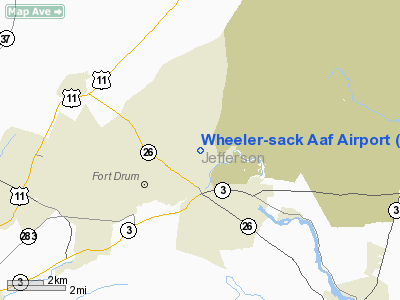
Wheeler-Sack Army Airfield (ICAO: KGTB, FAA LID: GTB) is a military use airport located at Fort Drum, in Jefferson County, New York, United States. It is owned by U.S. Army.
Although most U.S. airports use the same three-letter location identifier for the FAA and IATA, this airport is assigned GTB by the FAA but has no designation from the IATA (which assigned GTB to Genting Airport in Malaysia). History
Although in use in the early years of army aviation supporting the "Pine Plains" military training ground, during World War II the airfield was extensively expanded for use by the United States Army Air Force as home of the 91st Observation Squadron, USAAF. The 91st was attached to the Army's 4th Armored Division, training at the time for the division's later role exploiting Operation Cobra in Northern France. Additions to the field including two new 4500' x 150' concrete runways and a steel hangar.
Throughout World War II and the Korean War, Wheeler-Sack continued to support the needs of Fort Drum, which ebbed and flowed with the Army's training needs.
When Fort Drum was designated as the new home of the Army's newly reactivated 10th Mountain Division in 1985, the reactivation ceremony was held in the steel hangar at Wheeler-Sack. The division, a part of the Army's component of the United States Rapid Deployment Force, was designed to be moved from the continental United States to distant theater on short notice. Initially, the components of the division that were air-transportable were moved via Griffiss Air Force Base.
But the logistics involved with moving personnel, equipment, and munitions across 85 miles of road made the arrangement less than optimal, and the Army chose to expand Wheeler-Sack. Completed in 1998, the expansion now allows Wheeler-Sack to accommodate any aircraft in the U.S. Air Force inventory, and with scales, an ammunition holding area, refueling points, and a vehicle staging and inspection area, the field can serve as the primary departure airfield for the 10th Mountain Division. The new pre-deployment processing facility at the airfield accommodates up to 1,200 soldiers, allowing entire battalions to stage directly to overseas destination from the field.
Facilities
Wheeler-Sack AAF has three runways with concrete surfaces: 3/21 is 10,000 by 150 feet (3,048 x 46 m), 8/26 is 4,482 by 150 feet (1,366 x 46 m), and 15/33 is 4,999 by 150 feet (1,524 x 46 m).
The above content comes from Wikipedia and is published under free licenses – click here to read more.
Location & QuickFacts
| FAA Information Effective: | 2008-09-25 |
| Airport Identifier: | GTB |
| Airport Status: | Operational |
| Longitude/Latitude: | 075-43-10.2000W/44-03-20.4000N
-75.719500/44.055667 (Estimated) |
| Elevation: | 690 ft / 210.31 m (Estimated) |
| Land: | 0 acres |
| From nearest city: | 1 nautical miles NE of Fort Drum, NY |
| Location: | Jefferson County, NY |
| Magnetic Variation: | 13W (1990) |
Owner & Manager
| Ownership: | Army owned |
| Owner: | Us Army Atca-aso |
| Address: | Cameron Station
Alexandria, VA 22314 |
| Address: |
|
Airport Operations and Facilities
| Airport Use: | Private |
| Segmented Circle: | No |
| Control Tower: | Yes |
| Lighting Schedule: | DUSK-DAWN |
| Beacon Color: | Split-Clear-Green (lighted military airport)
LCTD ON 847'MSL TOWER WEST OF RWY 8. |
| Sectional chart: | Montreal |
| Region: | AEA - Eastern |
| Boundary ARTCC: | ZBW - Boston |
| Tie-in FSS: | BTV - Burlington |
| FSS on Airport: | No |
| FSS Toll Free: | 1-800-WX-BRIEF |
| NOTAMs Facility: | BTV (NOTAM-d service avaliable) |
Runway Information
Runway 03/21
| Dimension: | 10000 x 150 ft / 3048.0 x 45.7 m |
| Surface: | CONC, |
| Pavement Class: | 91 /R/B/W/T |
| Edge Lights: | High |
|
|
Runway 08/26
| Dimension: | 4482 x 150 ft / 1366.1 x 45.7 m |
| Surface: | CONC, |
| Pavement Class: | 9 /R/C/W/T |
| Edge Lights: | Low |
| |
Runway 08 |
Runway 26 |
| Traffic Pattern: | Left | Left |
|
Runway 15/33
| Dimension: | 4999 x 150 ft / 1523.7 x 45.7 m |
| Surface: | CONC, |
| Pavement Class: | 59 /R/C/W/T |
| Edge Lights: | High |
| |
Runway 15 |
Runway 33 |
| Longitude: | 075-43-28.9450W | 075-42-39.5490W |
| Latitude: | 44-03-42.5470N | 44-03-08.3800N |
| Elevation: | 664.00 ft | 688.00 ft |
| Traffic Pattern: | Left | Left |
| Approach lights: | MALSR | |
|
Radio Navigation Aids
| ID |
Type |
Name |
Ch |
Freq |
Var |
Dist |
| GTB | NDB | Drum | | 257.00 | 13W | 1.1 nm |
| ART | VORTAC | Watertown | 035X | 109.80 | 12W | 16.2 nm |
Remarks
- FUEL: PPR. J8-AVBL 1200-0200Z+ MON-FRI, OT PN.
- WX OBSERVATION VIEW OBSTRUCTED BY BUILDINGS WEST THRU NORTHEAST (250-060 DEGREES). VSBY EVALUATION IS LIMITED TO 1/4 TO 1/16 OF A MILE IN THIS SECTOR.
- NS ABTMT- FLY FRIENDLY PROGRAM IN EFF. DOES NOT APPLY TO APOE MSN ACFT. QUIET HR POLICY FOR TRAN AIRCREWS CONDUCTING PRACTICE APRCH AND TRNG FLT 0300-100Z ++, CTC AFLD MGR THRU BASE OPS FOR EXC.
- TRAN ALERT: LTD.
- RSTD: 24 HR PPR DSN 772-5681, C315-772-5681. PN RQR BY 2100Z+ FRI FOR WKEND AND FLW MON. TKOF RWY 26 AND LDG RWY 08 VFR ONLY FOR CAT B, C, D ACFT. RWY 03/21 ACCELERATE STOP AND TKOF RUN DIST AVBL 10,000 .
- CAUTION: LGT STACK 860 ' 2 NM W OF ARPT. R5201 E OF AFLD, HVY ARTILLERY, R/W/AND F/W/JET ACFT ACT.
- TFC PAT: R/W1400', F/W/2200. TURBO JET 2700'.
- CSTMS/AG/IMG: CSTMS AND AG RQR 24 HR ADVANCE NTC, COORD THRU BASE OPS.
- MISC: NO MAINT. FULL WX SVC AVBL. DSN 772-6065. NOTIFY TWR 20 MIN OUT WITH CODE 6 AND ABV ON BOARD. ALL TRAN COPTER ENROUTE R5201 MUST STOP GTB FOR RQR SAFETY BRIEF. BASE OPS MON-FRI 1200-0400Z+; WKEND 130-2100Z+ OT PN. NARROW TWY A,B, ARC 40' WIDE.
- MISC: TIGHT TURNS RQR FR TWY A TO B AND B TO A, ADVS GND IF ACFT CANNOT MAKE THESE TURNS. ACFT INBD FOR DIRECTORATE OF LOGISTICS AVIATION INTERMEDIATE MAINTENANCE MUST ARR NO LATER THAN 1900Z+, CTC C315-772-7538, DSN 772-7538.
- ALL TRANSIENT AIRCRAFT MUST NOTIFY BASE OPS NLT 20 MIN OUT AND MUST CONTACT GTB APPROACH CONTROL WITHIN 25-30 NM OF GTB AND ADVISE OF INTENSIONS. ACFT THAT PLAN ON ARRIVING GTB VIA AN IR OR VR ROUTE MUST INFORM BASE OPS WHEN REQUESTING PPR.
Images and information placed above are from
http://www.airport-data.com/airport/GTB/
We thank them for the data!
| General Info
|
| Country |
United States
|
| State |
NEW YORK
|
| FAA ID |
GTB
|
| Latitude |
44-03-06.000N
|
| Longitude |
075-43-18.000W
|
| Elevation |
691 feet
|
| Near City |
FORT DRUM
|
We don't guarantee the information is fresh and accurate. The data may
be wrong or outdated.
For more up-to-date information please refer to other sources.
|
|


