|
|
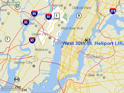
| West 30th Street Heliport |
 |
| IATA: JRA – ICAO: KJRA – FAA LID: JRA |
| Summary |
| Airport type |
Public |
| Owner |
Hudson River Park Trust |
| Operator |
Abigail Trenk, Brian Tolbert |
| Serves |
New York City |
| Location |
New York City, New York |
| Elevation AMSL |
7 ft / 2.1 m |
| Coordinates |
40°45′17″N 74°00′25″W / 40.754626°N 74.006808°W / 40.754626; -74.006808Coordinates: 40°45′17″N 74°00′25″W / 40.754626°N 74.006808°W / 40.754626; -74.006808 |
| Helipads |
| Number |
Length |
Surface |
| ft |
m |
| 1 |
44 |
13.4 |
Asphalt |
| 2 |
44 |
13.4 |
Asphalt |
| 3 |
44 |
13.4 |
Asphalt |
| 4 |
44 |
13.4 |
Asphalt |
| 5 |
37 |
11.3 |
Asphalt |
| 6 |
37 |
11.3 |
Asphalt |
| 7 |
37 |
11.3 |
Asphalt |
| 8 |
44 |
13.4 |
Asphalt |
| 9 |
44 |
13.4 |
Asphalt |
| 10 |
37 |
11.3 |
Asphalt |
| 11 |
37 |
11.3 |
Asphalt |
| Source: Airnav: |
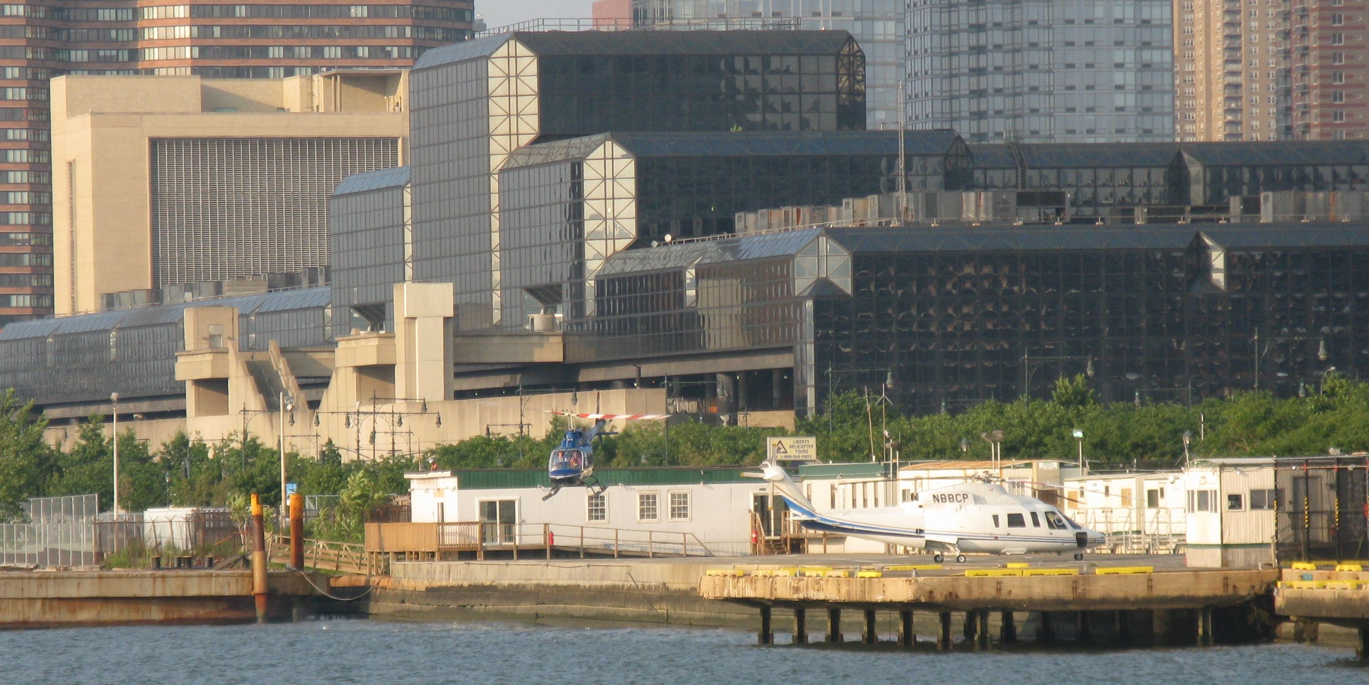
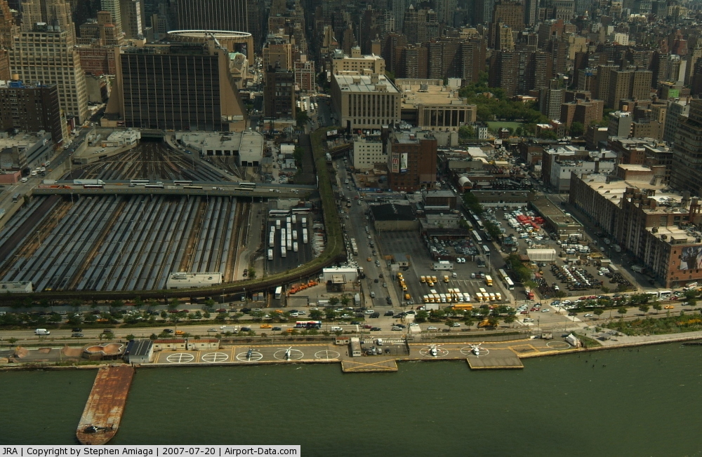
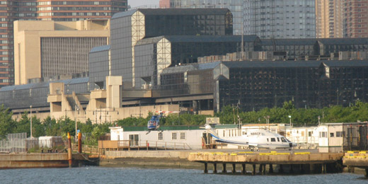
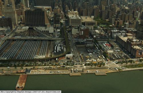
The West 30th Street Heliport (IATA: JRA, ICAO: KJRA, FAA LID: JRA) is a heliport on the west side of Manhattan in New York City. The heliport opened on September 26, 1956. Operations
Since this is a heliport and not an airport, there are no Instrument Procedures for this facility. The level of boating traffic in the neighboring Hudson River requires that pilots exercise caution in making their approach to the heliport's landing pad.
Tourist flights out of the 30th Street Heliport are scheduled to move to Downtown Manhattan Heliport on March 31, 2010 and the heliport itself is scheduled to relocate by on December 31, 2012 as a result of a court agreement between helicopter operators and Friends of Hudson River Park who took action to enforce the Hudson River Park Act which banned tourism flights from that location.
Statistics
73% of the flights are air taxi, 16% general aviation, 10% commercial, and less than 1% military.
Accidents and incidents
- On June 25, 1968, a Brantly 305 on a sightseeing flight crashed into the Hudson River shortly after takeoff from the West 30th Street Heliport. The pilot and all five passengers were rescued.
- On December 31, 1997, an Aérospatiale AS-355 returning from a sightseeing flight crashed into a building at the West 30th Street Heliport. Eight people were injured in the accident.
- On July 7, 2007, a Eurocopter EC130 B4 returning to the West 30th Street Heliport from a sightseeing flight had an engine malfunction and made a controlled landing in the Hudson River, deploying its emergency pontoons. The pilot and seven passengers were rescued from private boats.
- On August 8, 2009, nine people were killed when a Liberty Helicopters sightseeing helicopter collided with a private plane shortly after takeoff from the West 30th Street Heliport. Both aircraft were operating on visual flight rules.
The above content comes from Wikipedia and is published under free licenses – click here to read more.
 |
(Click on the photo to enlarge) |
 |
(Click on the photo to enlarge) |
Location & QuickFacts
| FAA Information Effective: | 2008-09-25 |
| Airport Identifier: | JRA |
| Airport Status: | Operational |
| Longitude/Latitude: | 074-00-25.5020W/40-45-16.3650N
-74.007084/40.754546 (Estimated) |
| Elevation: | 7 ft / 2.13 m (Estimated) |
| Land: | 2 acres |
| From nearest city: | 0 nautical miles N of New York, NY |
| Location: | New York County, NY |
| Magnetic Variation: | 13W (1985) |
Owner & Manager
| Ownership: | Publicly owned |
| Owner: | Hudson River Park Trust |
| Address: | Pier 40 West Houston Street
New York, NY 10007 |
| Phone number: | 212-627-2020 |
| Manager: | Abigail Trenk
ALSO BRIAN TOLBERT. |
| Address: | West 30 St & 12 Ave.
New York, NY 10001 |
| Phone number: | 212-563-4442 |
Airport Operations and Facilities
| Airport Use: | Open to public |
| Wind indicator: | Yes |
| Segmented Circle: | No |
| Control Tower: | No |
| Lighting Schedule: | DUSK-DAWN |
| Landing fee charge: | Yes |
| Sectional chart: | New York |
| Region: | AEA - Eastern |
| Boundary ARTCC: | ZNY - New York |
| Tie-in FSS: | ISP - New York |
| FSS on Airport: | No |
| FSS Toll Free: | 1-800-WX-BRIEF |
| NOTAMs Facility: | ISP (NOTAM-d service avaliable) |
| Federal Agreements: | N |
Airport Communications
| CTAF: | 123.050 |
| Unicom: | 123.050 |
Airport Services
| Fuel available: | A |
| Airframe Repair: | NONE |
| Power Plant Repair: | NONE |
| Bottled Oxygen: | NONE |
| Bulk Oxygen: | NONE |
Runway Information
Helipad H1
| Dimension: | 44 x 44 ft / 13.4 x 13.4 m
RYS H1, H2, & H3 REMEASURED. |
| Surface: | ASPH, |
| Weight Limit: | Single wheel: 6000 lbs. |
| |
Runway H1 |
Runway |
| Traffic Pattern: | Right | Left |
| Runway End Identifier: | No | |
| Centerline Lights: | No | |
| Touchdown Lights: | No | |
|
Helipad H10
| Dimension: | 44 x 44 ft / 13.4 x 13.4 m
RYS H1, H2, & H3 REMEASURED. |
| Surface: | ASPH, |
| |
Runway H10 |
Runway |
| Traffic Pattern: | Left | Left |
|
Helipad H11
| Dimension: | 44 x 44 ft / 13.4 x 13.4 m
RYS H1, H2, & H3 REMEASURED. |
| Surface: | ASPH, |
| |
Runway H11 |
Runway |
| Traffic Pattern: | Left | Left |
|
Helipad H2
| Dimension: | 44 x 44 ft / 13.4 x 13.4 m
RYS H1, H2, & H3 REMEASURED. |
| Surface: | ASPH, |
| Weight Limit: | Single wheel: 6000 lbs. |
| |
Runway H2 |
Runway |
| Traffic Pattern: | Right | Left |
|
Helipad H3
| Dimension: | 44 x 44 ft / 13.4 x 13.4 m
RYS H1, H2, & H3 REMEASURED. |
| Surface: | ASPH, Good Condition |
| |
Runway H3 |
Runway |
| Traffic Pattern: | Left | Left |
|
Helipad H4
| Dimension: | 44 x 44 ft / 13.4 x 13.4 m
RYS H1, H2, & H3 REMEASURED. |
| Surface: | ASPH, |
| |
Runway H4 |
Runway |
| Traffic Pattern: | Left | Left |
|
Helipad H5
| Dimension: | 37 x 37 ft / 11.3 x 11.3 m
RYS H1, H2, & H3 REMEASURED. |
| Surface: | ASPH, |
| |
Runway H5 |
Runway |
| Traffic Pattern: | Left | Left |
|
Helipad H6
| Dimension: | 37 x 37 ft / 11.3 x 11.3 m
RYS H1, H2, & H3 REMEASURED. |
| Surface: | ASPH, |
| |
Runway H6 |
Runway |
| Traffic Pattern: | Left | Left |
|
Helipad H7
| Dimension: | 37 x 37 ft / 11.3 x 11.3 m
RYS H1, H2, & H3 REMEASURED. |
| Surface: | ASPH, |
| |
Runway H7 |
Runway |
| Traffic Pattern: | Left | Left |
|
Helipad H8
| Dimension: | 44 x 44 ft / 13.4 x 13.4 m
RYS H1, H2, & H3 REMEASURED. |
| Surface: | ASPH, |
| |
Runway H8 |
Runway |
| Traffic Pattern: | Left | Left |
|
Helipad H9
| Dimension: | 44 x 44 ft / 13.4 x 13.4 m
RYS H1, H2, & H3 REMEASURED. |
| Surface: | ASPH, |
| |
Runway H9 |
Runway |
| Traffic Pattern: | Left | Left |
|
Radio Navigation Aids
| ID |
Type |
Name |
Ch |
Freq |
Var |
Dist |
| EWR | FAN MARKER | Maryann | | | 11W | 8.8 nm |
| SKU | FAN MARKER | Stanwyck | | | 12W | 46.5 nm |
| OGY | NDB | Bridge | | 414.00 | 12W | 12.6 nm |
| PNJ | NDB | Paterson | | 347.00 | 12W | 13.3 nm |
| CAT | NDB | Chatham | | 254.00 | 11W | 19.3 nm |
| BBN | NDB | Babylon | | 275.00 | 14W | 28.8 nm |
| OP | NDB | Old Field Point Light | | 316.00 | 13W | 42.6 nm |
| SW | NDB | Neely | | 335.00 | 14W | 45.1 nm |
| NEL | NDB | Lakehurst | | 396.00 | 13W | 45.2 nm |
| SKU | NDB | Stanwyck | | 261.00 | 12W | 46.5 nm |
| PO | NDB | Meier | | 403.00 | 12W | 49.4 nm |
| NEL | TACAN | Lakehurst | 055X | | 11W | 45.9 nm |
| NEL | UHF/NDB | Lakehurst | | 274.80 | 13W | 45.2 nm |
| TEB | VOR/DME | Teterboro | 021X | 108.40 | 11W | 6.2 nm |
| LGA | VOR/DME | La Guardia | 078X | 113.10 | 12W | 6.2 nm |
| CRI | VOR/DME | Canarsie | 070X | 112.30 | 11W | 10.0 nm |
| JFK | VOR/DME | Kennedy | 106X | 115.90 | 12W | 13.0 nm |
| COL | VOR/DME | Colts Neck | 101X | 115.40 | 11W | 27.5 nm |
| DPK | VOR/DME | Deer Park | 124X | 117.70 | 12W | 32.1 nm |
| SBJ | VOR/DME | Solberg | 076X | 112.90 | 10W | 35.0 nm |
| CMK | VOR/DME | Carmel | 113X | 116.60 | 12W | 37.0 nm |
| BWZ | VOR/DME | Broadway | 089X | 114.20 | 11W | 37.2 nm |
| STW | VOR/DME | Stillwater | 033X | 109.60 | 11W | 41.8 nm |
| BDR | VOR/DME | Bridgeport | 25X | 108.80 | 12W | 46.9 nm |
| HUO | VOR/DME | Huguenot | 108X | 116.10 | 11W | 47.5 nm |
| SAX | VORTAC | Sparta | 104X | 115.70 | 11W | 30.6 nm |
| RBV | VORTAC | Robbinsville | 085X | 113.80 | 10W | 40.0 nm |
| JFK | VOT | Kennedy | | 115.10 | | 12.6 nm |
| ISP | VOT | Long Island Mac Arthur | | 109.40 | | 41.6 nm |
| BDR | VOT | Bridgeport | | 109.25 | | 46.9 nm |
Remarks
- FIRE ALARM BOX TO NEARBY FIREHOUSE LCTD AT FAC.
- PARKING AVAILABLE.
- H3 NO INGRESS/EGRESS OVER 12TH AVENUE.
- ALL TKOFS & LDGS MADE ONLY OVER HUDSON RIVER.
Images and information placed above are from
http://www.airport-data.com/airport/JRA/
We thank them for the data!
| General Info
|
| Country |
United States
|
| State |
NEW YORK
|
| FAA ID |
JRA
|
| Latitude |
40-45-16.365N
|
| Longitude |
074-00-25.502W
|
| Elevation |
7 feet
|
| Near City |
NEW YORK
|
We don't guarantee the information is fresh and accurate. The data may
be wrong or outdated.
For more up-to-date information please refer to other sources.
|
|