 |
|
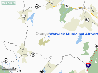
| Warwick Municipal Airport |
| IATA: none – ICAO: none – FAA LID: N72 |
| Summary |
| Airport type |
Public |
| Operator |
Town of Warwick |
| Location |
Warwick (town), New York |
| Elevation AMSL |
540 ft / 165 m |
| Coordinates |
41°17′15″N 074°17′14″W / 41.2875°N 74.28722°W / 41.2875; -74.28722Coordinates: 41°17′15″N 074°17′14″W / 41.2875°N 74.28722°W / 41.2875; -74.28722 |
| Runways |
| Direction |
Length |
Surface |
| ft |
m |
| 8/26 |
2,250 |
686 |
Sod |
| 3L/21R |
2,100 |
640 |
Turf |
| 3R/21L |
2,150 |
655 |
Asphalt |
Warwick Municipal Airport (FAA LID: N72) is a public-use airport located three miles (5 km) northeast of the central business district of Warwick, a town in Orange County, New York, United States. This general aviation airport is publicly owned by Town of Warwick. It has been in operation since 1946.
Facilities
Warwick Municipal Airport covers 133 acres (54 ha) and has three runways:
- Runway 8/26: 2,250 x 80 ft. (686 x 24 m), Surface: Turf
- Runway 3L/21R: 2,100 x 50 ft. (640 x 15 m), Surface: Turf
- Runway 3R/21L: 2,150 x 28 ft. (655 x 9 m), Surface: Asphalt
The above content comes from Wikipedia and is published under free licenses – click here to read more.
Location & QuickFacts
| FAA Information Effective: | 2008-09-25 |
| Airport Identifier: | N72 |
| Airport Status: | Operational |
| Longitude/Latitude: | 074-17-13.5410W/41-17-15.3370N
-74.287095/41.287594 (Estimated) |
| Elevation: | 540 ft / 164.59 m (Surveyed) |
| Land: | 133 acres |
| From nearest city: | 3 nautical miles NE of Warwick, NY |
| Location: | Orange County, NY |
| Magnetic Variation: | 13W (1985) |
Owner & Manager
| Ownership: | Publicly owned |
| Owner: | Town Of Warwick |
| Address: | Box 489
Warwick, NY 10990 |
| Phone number: | 845-986-9544 |
| Manager: | David Mcmillan |
| Address: | 41 Airport Rd
Warwick, NY 10990 |
| Phone number: | 845-987-1320 |
Airport Operations and Facilities
| Airport Use: | Open to public |
| Wind indicator: | Yes |
| Segmented Circle: | No |
| Control Tower: | No |
| Lighting Schedule: | RDO-CTL
ACTVT LIRL RY 03R/21L - CTAF. |
| Landing fee charge: | No |
| Sectional chart: | New York |
| Region: | AEA - Eastern |
| Traffic Pattern Alt: | 960 ft |
| Boundary ARTCC: | ZNY - New York |
| Tie-in FSS: | ISP - New York |
| FSS on Airport: | No |
| FSS Toll Free: | 1-800-WX-BRIEF |
| NOTAMs Facility: | ISP (NOTAM-d service avaliable) |
| Federal Agreements: | N |
Airport Communications
| CTAF: | 123.000 |
| Unicom: | 123.000 |
Airport Services
| Fuel available: | 100LL
SELF SVC FUEL AVBL. |
| Airframe Repair: | MAJOR |
| Power Plant Repair: | MAJOR |
| Bottled Oxygen: | NONE |
| Bulk Oxygen: | NONE |
Runway Information
Runway 03L/21R
| Dimension: | 2100 x 50 ft / 640.1 x 15.2 m |
| Surface: | TURF, Good Condition
RY 03R/21L NUMEROUS TRANSVERSE CRACKS 1-3 IN. WIDE. |
| |
Runway 03L |
Runway 21R |
| Traffic Pattern: | Left | Left |
| Obstruction: | 10 ft tree, 30.0 ft from runway, 55 ft left of centerline, 3:1 slope to clear | 63 ft trees, 0.0 ft from runway, 25 ft right of centerline |
|
Runway 03R/21L
| Dimension: | 2150 x 28 ft / 655.3 x 8.5 m |
| Surface: | ASPH, Fair Condition
RY 03R/21L NUMEROUS TRANSVERSE CRACKS 1-3 IN. WIDE. |
| Edge Lights: | Non-standard lighting system
NSTD LIRL; SPACING 400 FT APART & NO THLD LGTS. |
| |
Runway 03R |
Runway 21L |
| Traffic Pattern: | Left | Left |
| Markings: | Numbers only, Fair Condition | Numbers only, Good Condition |
| Runway End Identifier: | No | No |
| Obstruction: | 96 ft tree, 1400.0 ft from runway, 150 ft right of centerline, 12:1 slope to clear
50 FT TREES 0 FT FM THLD 70 FT R. | 10 ft brush, 200.0 ft from runway, 67 ft left of centerline
RY 21L 10 FT BRUSH AT THLD 56 FT LEFT. |
|
Runway 08/26
| Dimension: | 2250 x 80 ft / 685.8 x 24.4 m |
| Surface: | TURF, Fair Condition
RY 03R/21L NUMEROUS TRANSVERSE CRACKS 1-3 IN. WIDE. |
| |
Runway 08 |
Runway 26 |
| Traffic Pattern: | Left | Left |
| Runway End Identifier: | No | No |
| Obstruction: | 52 ft tree, 94 ft right of centerline | 40 ft trees, 0.0 ft from runway, 90L/ ft right of centerline |
|
Radio Navigation Aids
| ID |
Type |
Name |
Ch |
Freq |
Var |
Dist |
| SKU | FAN MARKER | Stanwyck | | | 12W | 18.1 nm |
| EWR | FAN MARKER | Maryann | | | 11W | 35.4 nm |
| SW | NDB | Neely | | 335.00 | 14W | 12.2 nm |
| SKU | NDB | Stanwyck | | 261.00 | 12W | 18.1 nm |
| PNJ | NDB | Paterson | | 347.00 | 12W | 21.4 nm |
| PO | NDB | Meier | | 403.00 | 12W | 22.6 nm |
| CAT | NDB | Chatham | | 254.00 | 11W | 33.5 nm |
| MS | NDB | Monga | | 359.00 | 12W | 38.7 nm |
| OGY | NDB | Bridge | | 414.00 | 12W | 47.0 nm |
| HUO | VOR/DME | Huguenot | 108X | 116.10 | 11W | 15.6 nm |
| TEB | VOR/DME | Teterboro | 021X | 108.40 | 11W | 28.3 nm |
| IGN | VOR/DME | Kingston | 123X | 117.60 | 12W | 30.9 nm |
| STW | VOR/DME | Stillwater | 033X | 109.60 | 11W | 31.6 nm |
| CMK | VOR/DME | Carmel | 113X | 116.60 | 12W | 31.9 nm |
| LGA | VOR/DME | La Guardia | 078X | 113.10 | 12W | 35.3 nm |
| BWZ | VOR/DME | Broadway | 089X | 114.20 | 11W | 38.1 nm |
| PWL | VOR/DME | Pawling | 090X | 114.30 | 12W | 42.4 nm |
| CRI | VOR/DME | Canarsie | 070X | 112.30 | 11W | 44.3 nm |
| JFK | VOR/DME | Kennedy | 106X | 115.90 | 12W | 45.8 nm |
| SBJ | VOR/DME | Solberg | 076X | 112.90 | 10W | 47.1 nm |
| SAX | VORTAC | Sparta | 104X | 115.70 | 11W | 17.4 nm |
| JFK | VOT | Kennedy | | 115.10 | | 45.5 nm |
Remarks
- ARPT CLSD TO TSNT ACFT SS-SR.
- NO PRACTICE LNDGS.
- MOUNTAINS & TWRS IN CLOSE VICINITY OF ARPT.
- ARPT IN OPERN SINCE 1946.
Images and information placed above are from
http://www.airport-data.com/airport/N72/
We thank them for the data!
| General Info
|
| Country |
United States
|
| State |
NEW YORK
|
| FAA ID |
N72
|
| Latitude |
41-17-15.337N
|
| Longitude |
074-17-13.541W
|
| Elevation |
540 feet
|
| Near City |
WARWICK
|
We don't guarantee the information is fresh and accurate. The data may
be wrong or outdated.
For more up-to-date information please refer to other sources.
|
|


