 |
|
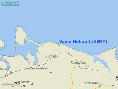
Location & QuickFacts
| FAA Information Effective: | 2008-09-25 |
| Airport Identifier: | 26NY |
| Airport Status: | Operational |
| Longitude/Latitude: | 073-18-22.4150W/40-55-30.3520N
-73.306226/40.925098 (Estimated) |
| Elevation: | 100 ft / 30.48 m (Estimated) |
| Land: | 300 acres |
| From nearest city: | 2 nautical miles SE of Northport, NY |
| Location: | Suffolk County, NY |
| Magnetic Variation: | 14W (1990) |
Owner & Manager
| Ownership: | Publicly owned |
| Owner: | Vamc Northport-ny-fed Gov't |
| Address: | 79 Middleville Road
Northport, NY 11768 |
| Phone number: | 516-261-4400 |
| Manager: | Alice L Wood - Med Ctr Dir |
| Address: | Vamc 79 Middleville Road
Northport, NY 11768 |
| Phone number: | 516-261-4400
EXT 2747. |
Airport Operations and Facilities
| Airport Use: | Private
MEDICAL USE. |
| Wind indicator: | Yes |
| Segmented Circle: | No |
| Control Tower: | No |
| Sectional chart: | New York |
| Region: | AEA - Eastern |
| Boundary ARTCC: | ZBW - Boston |
| Tie-in FSS: | ISP - New York |
| FSS on Airport: | No |
| FSS Toll Free: | 1-800-WX-BRIEF |
Runway Information
Helipad H1
| Dimension: | 30 x 30 ft / 9.1 x 9.1 m |
| Surface: | CONC, |
| |
Runway H1 |
Runway |
| Traffic Pattern: | Left | Left |
|
Radio Navigation Aids
| ID |
Type |
Name |
Ch |
Freq |
Var |
Dist |
| EWR | FAN MARKER | Maryann | | | 11W | 42.2 nm |
| SKU | FAN MARKER | Stanwyck | | | 12W | 49.3 nm |
| OP | NDB | Old Field Point Light | | 316.00 | 13W | 9.1 nm |
| BBN | NDB | Babylon | | 275.00 | 14W | 15.6 nm |
| OGY | NDB | Bridge | | 414.00 | 12W | 33.9 nm |
| TBY | NDB | Waterbury | | 257.00 | 14W | 37.0 nm |
| PNJ | NDB | Paterson | | 347.00 | 12W | 38.4 nm |
| MMK | NDB | Meriden | | 238.00 | 14W | 41.3 nm |
| PO | NDB | Meier | | 403.00 | 12W | 49.1 nm |
| SKU | NDB | Stanwyck | | 261.00 | 12W | 49.3 nm |
| FOK | TACAN | Suffolk Co | 047X | | 13W | 31.1 nm |
| DPK | VOR/DME | Deer Park | 124X | 117.70 | 12W | 8.0 nm |
| BDR | VOR/DME | Bridgeport | 25X | 108.80 | 12W | 16.4 nm |
| CCC | VOR/DME | Calverton | 119X | 117.20 | 13W | 23.0 nm |
| CMK | VOR/DME | Carmel | 113X | 116.60 | 12W | 24.7 nm |
| LGA | VOR/DME | La Guardia | 078X | 113.10 | 12W | 27.2 nm |
| JFK | VOR/DME | Kennedy | 106X | 115.90 | 12W | 27.5 nm |
| HVN | VOR/DME | New Haven | 035X | 109.80 | 13W | 27.8 nm |
| CRI | VOR/DME | Canarsie | 070X | 112.30 | 11W | 32.7 nm |
| TEB | VOR/DME | Teterboro | 021X | 108.40 | 11W | 34.7 nm |
| MAD | VOR/DME | Madison | 041X | 110.40 | 13W | 36.3 nm |
| HTO | VORTAC | Hampton | 083X | 113.60 | 13W | 44.9 nm |
| ISP | VOT | Long Island Mac Arthur | | 109.40 | | 12.6 nm |
| BDR | VOT | Bridgeport | | 109.25 | | 16.4 nm |
| JFK | VOT | Kennedy | | 115.10 | | 27.7 nm |
Remarks
- ALL PILOTS FLYING INTO THE VAMC ARE TO BE BRIEFED IN ADVANCE AS TO ARR & DEP FLT PATHS.
- VFR USE ONLY; RELOCATED WIND INDICATOR.
Images and information placed above are from
http://www.airport-data.com/airport/26NY/
We thank them for the data!
| General Info
|
| Country |
United States
|
| State |
NEW YORK
|
| FAA ID |
26NY
|
| Latitude |
40-55-30.352N
|
| Longitude |
073-18-22.415W
|
| Elevation |
100 feet
|
| Near City |
NORTHPORT
|
We don't guarantee the information is fresh and accurate. The data may
be wrong or outdated.
For more up-to-date information please refer to other sources.
|
|


