 |
|
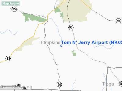
Location & QuickFacts
| FAA Information Effective: | 2008-09-25 |
| Airport Identifier: | NK05 |
| Airport Status: | Operational |
| Longitude/Latitude: | 076-30-57.7900W/42-21-17.2640N
-76.516053/42.354796 (Estimated) |
| Elevation: | 1490 ft / 454.15 m (Estimated) |
| Land: | 0 acres |
| From nearest city: | 2 nautical miles W of Danby, NY |
| Location: | Tompkins County, NY |
| Magnetic Variation: | 12W (1985) |
Owner & Manager
| Ownership: | Privately owned |
| Owner: | Jerrold A. Friedman
GAETANO D'AMBROSE. |
| Address: | 375 Gunderman Road
Spencer, NY 14883 |
| Phone number: | 607-273-6443 |
| Address: |
|
Airport Operations and Facilities
| Airport Use: | Private |
| Wind indicator: | Yes |
| Segmented Circle: | No |
| Control Tower: | No |
| Landing fee charge: | No |
| Sectional chart: | New York |
| Region: | AEA - Eastern |
| Boundary ARTCC: | ZNY - New York |
| Tie-in FSS: | BUF - Buffalo |
| FSS on Airport: | No |
| FSS Toll Free: | 1-800-WX-BRIEF |
Runway Information
Runway 18/36
| Dimension: | 1200 x 30 ft / 365.8 x 9.1 m |
| Surface: | TURF, |
| |
Runway 18 |
Runway 36 |
| Traffic Pattern: | Left | Left |
| Obstruction: | 60 ft trees, 200.0 ft from runway | 60 ft trees, 200.0 ft from runway |
|
Radio Navigation Aids
| ID |
Type |
Name |
Ch |
Freq |
Var |
Dist |
| ALP | NDB | Alpine | | 245.00 | 12W | 13.0 nm |
| PYA | NDB | Penn Yan | | 260.00 | 12W | 29.6 nm |
| ITH | VOR/DME | Ithaca | 055X | 111.80 | 10W | 8.8 nm |
| ULW | VOR/DME | Elmira | 033Y | 109.65 | 12W | 27.5 nm |
| CFB | VORTAC | Binghamton | 059X | 112.20 | 10W | 20.6 nm |
| GGT | VORTAC | Georgetown | 125X | 117.80 | 11W | 40.1 nm |
Remarks
- VFR USE ONLY;APROP TFC PAT BE DVLPD IN COORDINATION WITH CHIEF ITHACA ATCT...WITH A RIGHT-HAND PAT TO RWY 01 TO REMAIN CLEAR OF SKYHOOK LODGE APT.
Images and information placed above are from
http://www.airport-data.com/airport/NK05/
We thank them for the data!
| General Info
|
| Country |
United States
|
| State |
NEW YORK
|
| FAA ID |
NK05
|
| Latitude |
42-21-17.264N
|
| Longitude |
076-30-57.790W
|
| Elevation |
1490 feet
|
| Near City |
DANBY
|
We don't guarantee the information is fresh and accurate. The data may
be wrong or outdated.
For more up-to-date information please refer to other sources.
|
|


