 |
|
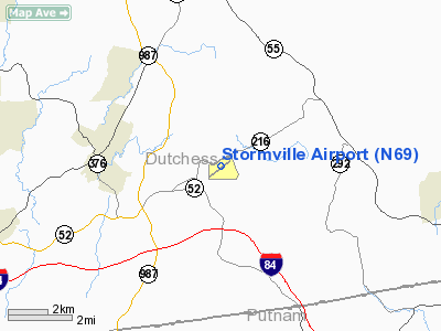
| Stormville Airport |
| IATA: none – ICAO: none – FAA LID: N69 |
| Summary |
| Airport type |
Public |
| Operator |
Tom Carnahan |
| Location |
Stormville, New York |
| Elevation AMSL |
358 ft / 109.1 m |
| Coordinates |
41°34′37″N 073°43′56″W / 41.57694°N 73.73222°W / 41.57694; -73.73222Coordinates: 41°34′37″N 073°43′56″W / 41.57694°N 73.73222°W / 41.57694; -73.73222 |
| Runways |
| Direction |
Length |
Surface |
| ft |
m |
| 6/24 |
3,315 |
1,010 |
Asphalt |
Stormville Airport (FAA LID: N69) is a public airport located one mile (2 km) northeast of the central business district (CBD) of Stormville, a hamlet located within the Town of East Fishkill in Dutchess County, New York, USA. This general aviation airport covers 155 acres (63 ha) and has one runway. It is no longer used as an airport. It is now the Stormville Flea Market.
Stormville is a privately owned, public use airport. Pete and Rose O'Brien ran the airport until their retirement. The current owner is their daughter Patricia Carnahan. There are no services for aircraft and no aircraft based there. Airport facilities such as runways, taxiways, wind sock, and pavement markings are in poor condition.
The above content comes from Wikipedia and is published under free licenses – click here to read more.
Location & QuickFacts
| FAA Information Effective: | 2008-09-25 |
| Airport Identifier: | N69 |
| Airport Status: | Operational |
| Longitude/Latitude: | 073-43-58.0000W/41-34-36.8000N
-73.732778/41.576889 (Estimated) |
| Elevation: | 358 ft / 109.12 m (Surveyed) |
| Land: | 155 acres |
| From nearest city: | 1 nautical miles NE of Stormville, NY |
| Location: | Dutchess County, NY |
| Magnetic Variation: | 12W (1975) |
Owner & Manager
| Ownership: | Privately owned |
| Owner: | Tom Carnahan |
| Address: | 428 Route 216
Stormville, NY 12582 |
| Phone number: | 845-221-6561 |
| Manager: | Tom Carnahan |
| Address: | 428 Route 216
Stormville, NY 12582 |
| Phone number: | 845-221-6561 |
Airport Operations and Facilities
| Airport Use: | Open to public |
| Wind indicator: | Yes |
| Segmented Circle: | No |
| Control Tower: | No |
| Landing fee charge: | No |
| Sectional chart: | New York |
| Region: | AEA - Eastern |
| Boundary ARTCC: | ZBW - Boston |
| Responsible ARTCC: | ZNY - New York |
| Tie-in FSS: | ISP - New York |
| FSS on Airport: | No |
| FSS Toll Free: | 1-800-WX-BRIEF |
| NOTAMs Facility: | ISP (NOTAM-d service avaliable) |
| Federal Agreements: | N |
Airport Communications
| CTAF: | 122.800 |
| Unicom: | 122.800 |
Airport Services
| Airframe Repair: | NONE |
| Power Plant Repair: | NONE |
| Bottled Oxygen: | NONE |
| Bulk Oxygen: | NONE |
Runway Information
Runway 06/24
| Dimension: | 3315 x 50 ft / 1010.4 x 15.2 m |
| Surface: | ASPH, Poor Condition
WIDE CRACKS & WEEDS ON RY. |
| Weight Limit: | Single wheel: 25000 lbs. |
| |
Runway 06 |
Runway 24 |
| Longitude: | 073-44-13.7550W | 073-43-42.2340W |
| Latitude: | 41-34-25.4390N | 41-34-48.0730N |
| Elevation: | 326.00 ft | 351.00 ft |
| Alignment: | 46 | 127 |
| Traffic Pattern: | Left | Left |
| Runway End Identifier: | No | No |
| Centerline Lights: | No | No |
| Touchdown Lights: | No | No |
| Obstruction: | 50 ft trees, 200.0 ft from runway
RWY 06 + 63 FT TREES AT RWY END AND 115 FT RIGHT. | 75 ft trees, 1474.0 ft from runway, 98 ft left of centerline, 16:1 slope to clear
RY 24 +10 FT, FIRST OF THREE GRVL ROADS, 25 FT FM THLD. VARIOUS MATERIALS MAY BE NEXT TO RY ENDS AFTER FLEA MARKETS. |
|
Radio Navigation Aids
| ID |
Type |
Name |
Ch |
Freq |
Var |
Dist |
| SKU | FAN MARKER | Stanwyck | | | 12W | 14.3 nm |
| GBR | FAN MARKER | Sheffield | | | 13W | 37.0 nm |
| PO | NDB | Meier | | 403.00 | 12W | 10.4 nm |
| SKU | NDB | Stanwyck | | 261.00 | 12W | 14.3 nm |
| SW | NDB | Neely | | 335.00 | 14W | 22.9 nm |
| TBY | NDB | Waterbury | | 257.00 | 14W | 26.6 nm |
| GBR | NDB | Great Barrington | | 395.00 | 14W | 39.3 nm |
| PFH | NDB | Philmont | | 272.00 | 13W | 40.6 nm |
| MMK | NDB | Meriden | | 238.00 | 14W | 40.9 nm |
| PNJ | NDB | Paterson | | 347.00 | 12W | 42.3 nm |
| OP | NDB | Old Field Point Light | | 316.00 | 13W | 45.5 nm |
| HF | NDB | Lomis | | 244.00 | 15W | 49.9 nm |
| IGN | VOR/DME | Kingston | 123X | 117.60 | 12W | 6.7 nm |
| PWL | VOR/DME | Pawling | 090X | 114.30 | 12W | 13.0 nm |
| CMK | VOR/DME | Carmel | 113X | 116.60 | 12W | 19.1 nm |
| BDR | VOR/DME | Bridgeport | 25X | 108.80 | 12W | 37.1 nm |
| HUO | VOR/DME | Huguenot | 108X | 116.10 | 11W | 40.0 nm |
| HVN | VOR/DME | New Haven | 035X | 109.80 | 13W | 42.6 nm |
| TEB | VOR/DME | Teterboro | 021X | 108.40 | 11W | 46.2 nm |
| LGA | VOR/DME | La Guardia | 078X | 113.10 | 12W | 47.9 nm |
| MAD | VOR/DME | Madison | 041X | 110.40 | 13W | 49.5 nm |
| SAX | VORTAC | Sparta | 104X | 115.70 | 11W | 47.5 nm |
| BDR | VOT | Bridgeport | | 109.25 | | 37.1 nm |
| HFD | VOT | Hartford | | 108.20 | | 49.5 nm |
Remarks
- RY 06/24 NOT PLOWED.
- GEESE ON & INVOF RWY (AUG-OCT)
- VARIOUS MATERIALS MAY BE NEXT TO RY ENDS AFTER FLEA MARKETS.
Images and information placed above are from
http://www.airport-data.com/airport/N69/
We thank them for the data!
| General Info
|
| Country |
United States
|
| State |
NEW YORK
|
| FAA ID |
N69
|
| Latitude |
41-34-37.136N
|
| Longitude |
073-43-56.470W
|
| Elevation |
358 feet
|
| Near City |
STORMVILLE
|
We don't guarantee the information is fresh and accurate. The data may
be wrong or outdated.
For more up-to-date information please refer to other sources.
|
|


