|
 |
|
||||
|
Stewart International Airport (IATA: SWF, ICAO: KSWF) is located west of Newburgh, New York, in the southern Hudson Valley, 60 miles (88.5 km) north of New York City and, 15 miles (23 km) southwest of Poughkeepsie, New York. Originally developed in the 1930s as a military base to allow cadets at the nearby United States Military Academy at West Point to learn aviation, it has over the years grown into the major passenger airport for the mid-Hudson region and continues to serve as a military airfield as well, currently housing the 105th Airlift Wing of the New York Air National Guard and Marine Aerial Refueler Transport Squadron 452 (VMGR-452) of the United States Marine Corps Reserve. The space shuttle could also land at Stewart in an emergency. It has made history in several ways. After its closure as an active Air Force base in the early 1970s, an ambitious plan by former Governor Nelson Rockefeller to greatly expand and develop the airport led to a bitter and protracted struggle with local landowners that led to reforms in the state's eminent domain laws but no actual development of the land acquired. In 1981 the 52 American hostages held in Iran made their return to American soil at Stewart. In 2000, the airport became the first U.S. commercial airport privatized when United Kingdom-based National Express Group was awarded a 99-year lease on the airport. It recently postponed plans to change the facility's name after considerable local opposition, and then announced plans to sell its rights to the airport. On January 25, 2007, the Port Authority of New York and New Jersey board voted to acquire the remaining 93 years of the lease, effectively ending the privatization experiment. It took over control of the airport on November 1 of that year. HistoryStewart Dairy FarmIn 1930 Thomas "Archie" Stewart, an early aviation enthusiast and descendant of prominent local dairy farmer Lachlan Stewart, convinced his uncle Samuel Stewart to donate "Stoney Lonesome", split between the towns of Newburgh and New Windsor, to the nearby city of Newburgh for use as an airport. However, with the city strapped for cash due to the Depression, it was unable to develop it in any way.
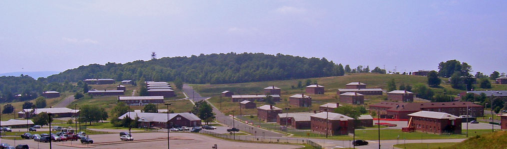
Stewart AirfieldIn 1934 Douglas MacArthur, then superintendent of the United States Military Academy, proposed flight training cadets at the airport. The city sold the land to the military academy for one dollar. A small dirt airstrip was cleared and graded. The northernmost gate at USMA has been known as Stoney Lonesome Gate ever since. During World War II many barracks and other buildings, which still stand, were built on the base. In January 2008, the Town of New Windsor received a $2.5 million grant from the state to demolish 30-40 buildings as part of the redevelopment of the former base. First Columbia, the developer, said that 20-30 could be retained and reused.
Stewart Air Force Base/Stewart Air National Guard Base
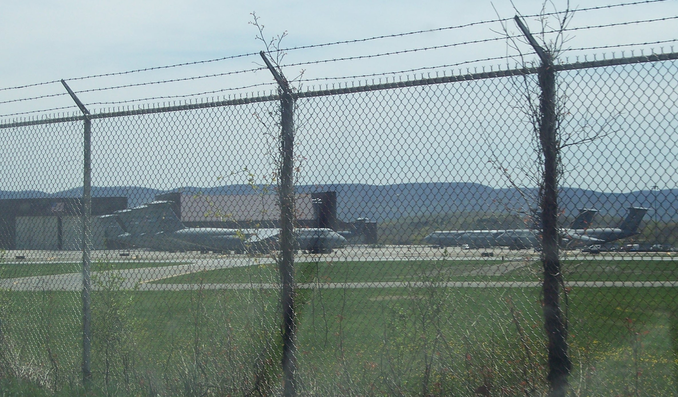
After the creation of the United States Air Force following World War II, the Army Airfield was converted to an Air Force Base while still being used for training of cadets at West Point. The Air Force base was deactivated in 1970 and it officially remained unoccupied until 1983 when the 105th Airlift Wing and 213th EIS of the New York Air National Guard took up quarters. The Air National Guard unit has flown support missions not only for U.S. military operations in Iraq and Afghanistan but also for humanitarian relief efforts. This area of the airport, now called Stewart Air National Guard Base, is one of the bases for the Air Force's C-5 Galaxy. In fact, the Air National Guard operates its only operations and maintenance base for the craft at Stewart. Stewart ANGB also hosts VMGR-452, a Marine Corps Reserve squadron flying the KC-130T. Stewart International AirportMTA Expansion planIn the early 1970s, Governor Nelson Rockefeller's administration saw the potential for Stewart to support the metropolitan area. Its long runway made it particularly attractive for intercontinental service via supersonic transport (SST), then under development in the U.S. and elsewhere. The Metropolitan Transportation Authority was the first government body to try to convert it into the New York metropolitan area's fourth major airport. It tripled the airport's territory, extending its land well beyond its previous western boundary at Drury Lane, a two-lane rural road. The state government used its eminent domain powers to take 7,500 acres (30 km²) for terminals, runways and a buffer zone expanding the airport from Newburgh into neighboring towns of Montgomery and a small portion of Hamptonburgh. The land was bounded by I-84 to the north, Route 207 along the south and roughly by Rock Tavern and Maybrook in the west. Local oppositionArea residents who were already fighting a large power plant proposal at nearby Storm King Mountain fiercely fought the expansion. They took the state to court, ultimately forcing the legislature to write and pass the New York State Eminent Domain Procedure Act, a sweeping overhaul of its existing law on the subject. In order to get the last holdouts off their land, state officials pledged that outside the proposed airport facilities, none of the land taken would ever be redeveloped, a promise that was to haunt them years later. By the time the land was finally available, the 1973 oil crisis and the attendant increase in the price of jet fuel had forced airlines to cut back, and some of the airport's original backers began arguing it was no longer economically viable. US SST development was canceled in 1971, undercutting another argument for the project. Malcolm Wilson, Rockefeller's successor, put the project on hold; and his successor, Hugh Carey, killed it for good in 1976. New York State Department of Transportation ownershipIn early 1981, the 52 U.S. hostages held at the former U.S. Embassy in Tehran, Iran, returned to American soil there following two weeks at U.S. bases in Germany and 444 days of captivity, ending the Iran hostage crisis. The route they took from there to West Point is marked today as "Freedom Road." The next year the state transferred control from MTA to its own Department of Transportation (NYSDOT), with a mandate to improve and develop the airport. Three years later W.R. Grace became the first private tenant when it built a corporate jet hangar, and the following year an industrial park was built nearby. Finally, in 1990, commercial airline service began with American Airlines offering service with three daily round trips to both Chicago and Raleigh-Durham. Continuing development issuesAs the 1980s wore on, veterans of earlier battles over Stewart returned to start new ones. NYSDOT and the Stewart Airport Commission found themselves overseeing not only the airport but the acres of now-vacant land the state had acquired a decade before. After turning over management of most of the property to the state's Department of Environmental Conservation (DEC), which was better equipped for the task, it still faced the problem of what to do with the land. The region's needs had changed. With IBM and other large industrial concerns cutting workers and closing plants, and people leaving, a large swath of buildable land with few environmental problems was seen by many in the local business community as a goose's golden egg. It couldn't be a sprawling airport, but it could be something else, they thought. But those people who remained or moved up from more crowded areas to the south had begun to enjoy the outdoor recreation possibilities the lands, referred to variously as the Stewart Properties or the buffer, offered. Mountain bikers, horses, dirt bikers, ATVers, and hikers had all begun to explore and create trails, and DEC's management opened up the area as a popular spot for local hunters and anglers. DEC had also released captured beavers on the properties, who built dams and created new wetlands. One local hunter, Ben Kissam, formed the Stewart Park and Reserve Coalition (SPARC) in 1987 to oppose efforts to develop the lands. They and other environmentalists and conservationists argued that the whole area would be better off left as a park, pointing to the growing diversity of species on the lands and the state's original promise not to redevelop the area. They were joined, too, by some area residents who said that the existing air traffic, particularly the military C-5s, were noisy enough as it was. Also generating a lot of noise was the continuing debate in Orange County about what to do with the land, with participants' choice of words ("buffer" vs. "properties") suggesting where they stood, and interpretations differing about just how much of the land was really meant to serve as a buffer. The administration of Mario Cuomo tried several times to come up with a plan that would balance these interests, but failed. One of its last acts was to set in motion a renovation of the passenger terminal using a federal grant.
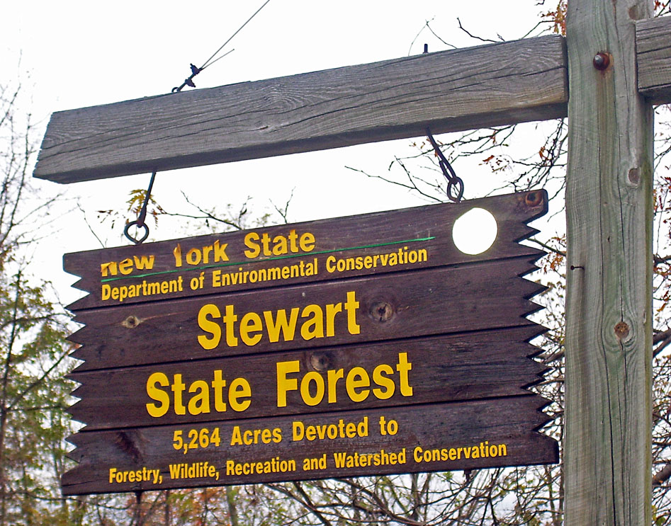
PrivatizationIn 1994 George Pataki campaigned on improving efficiencies by privatizing money-losing state projects. Ronald Lauder, who had written a book about European successes in privatizations, suggested Stewart be privatized. Pataki created the New York State Council on Privatization, and appointed Lauder its chair. Federal law at the time required that all airports providing passenger service had to be owned by some public entity. With much support from the New York delegation, the United States Congress eventually passed legislation allowing five airports to be privatized as a pilot program, providing certain conditions, such as approval by the Federal Aviation Administration (FAA) and by the carriers representing at least two-thirds of the airport's flights. In 1997 the state formally began, through the Empire State Development Corporation (ESDC), the process of soliciting bids for a 99-year lease on the airport and, potentially, the adjacent undeveloped lands as well, whatever bidders wanted. Efforts by SPARC, now headed by Kissam's widow Sandra, and other citizen activists to find out about who might be bidding and what they planned to do with Stewart were blocked by the state's invocation of a clause in its State Finance Law prohibiting disclosure of competitive bids prior to the award of the contract, an interpretation which survived a court challenge. Two years later, after approval by the state's attorney general and comptroller as well as the FAA and the carriers, the contract was awarded to the UK-based National Express Group PLC, the only one of five bidders to have declined to present at a special forum organized a week prior to award, and also a company Lauder had praised in his book for its success with the UK's national bus service and subsequent acquisition of East Midlands Airport, leading to some suspicions that the state had always intended to give them the airport from the beginning. NEG was prepared to pay $35 million for the lease, and after working out the details Pataki handed over a ceremonial key at the passenger terminal in late 2000. The award also ended, for the most part, the controversy over whether to develop the properties or not. NEG was uninterested in the lands west of Drury Lane, and Pataki announced with the privatization deal that he was directing that ownership as well as management of 5,600 acres (22.4 km²) of the lands west of an envelope DOT retained around Drury for possible future development or disposal be transferred directly to DEC, which has since made that portion Stewart State Forest. Stewart was one of the many regional airports to be used during the Emergency Ground Stop after the September 11th Attacks, taking in dozens of planes forced to land. The Drury Lane exit
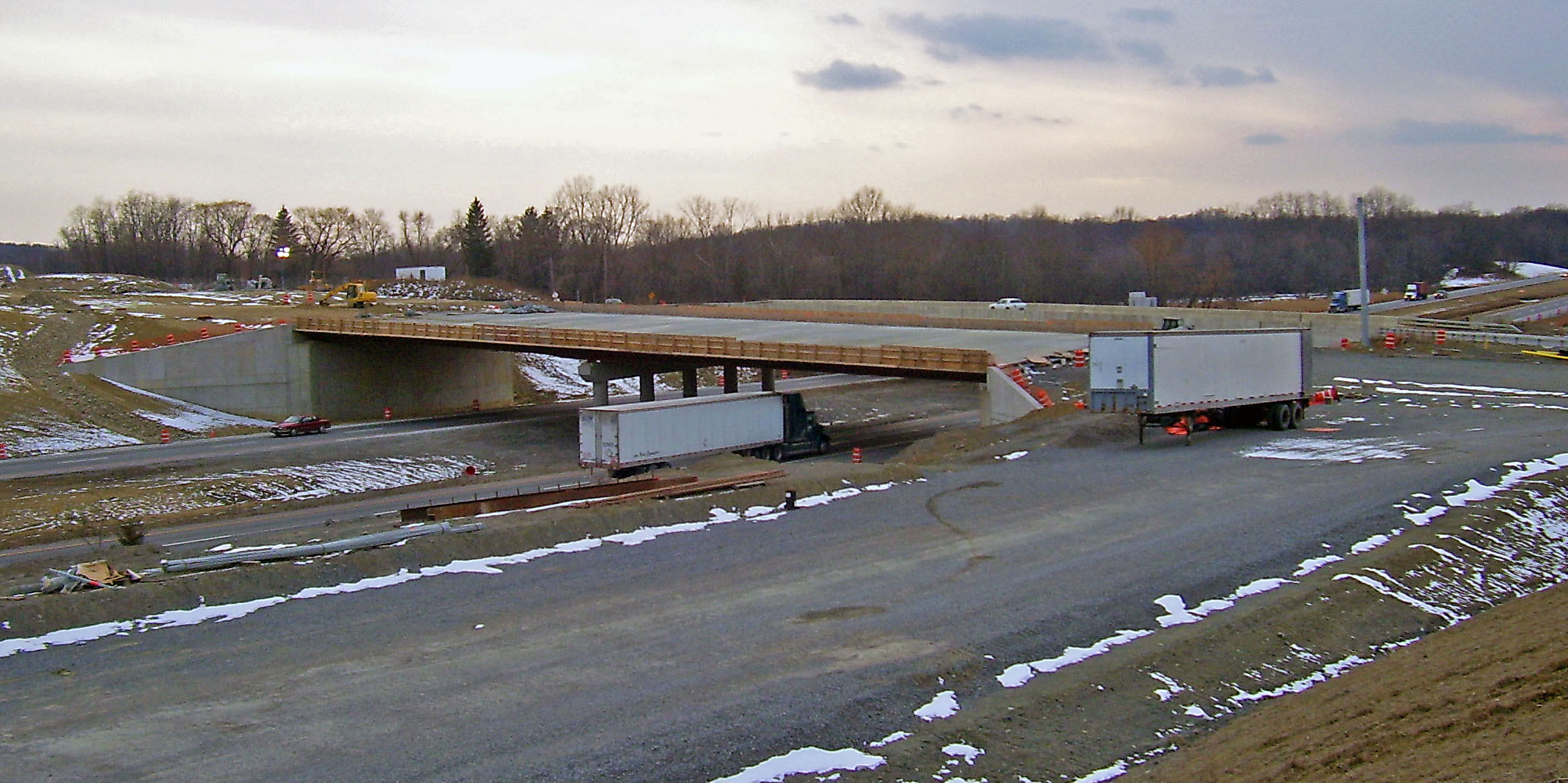
Simultaneously with the privatization, the state proceeded with long-held plans to build a new interchange on Interstate 84 at Drury Lane, which would also be widened. A four-lane east-west access road, International Boulevard, would also be created to better solve the airport's longstanding access problems (see below). Conveniently, the initial price tag, $35 million, was exactly the amount bid by National Express. The new exit, designated 5A, was opened in the fourth quarter of 2007. The new north-south route is now designated Route 747. This spurred immediate opposition from SPARC and other environmentalists, as it could only be justified by a desire to promote development along the stretch of Drury DOT had saved for itself. Residents of New Windsor were also outraged, as the airport access road, International Boulevard, goes right over a portion of Crestview Lake, a popular local park. Another complication emerged due to the proximity of the Catskill Aqueduct of New York City's water supply system to the exit; a proposed widening of Drury between the interstate and Route 17K would have required that a bridge be built over the aqueduct to protect it from the vibrations associated with heavy trucks, adding to the cost of the whole project. An alternative emerged during a value-engineering study of simply rerouting Drury to create another four-way intersection further down 17K, which was ultimately done. Whether the properties along Drury could even be developed in any measure remains to be seen, as a good portion of that parcel is either wetlands or a 45 acre trapezoid-shaped Runway Protection Zone in which the FAA mandates that nothing be built, and the remainder is land considered by conservationists to be the best land in the properties. SPARC, the Orange County Federation of Sportsmen's Clubs and the national Sierra Club filed a lawsuit in federal court alleging that required environmental reviews were not done or done improperly; that action tied up the exit's construction for a while. In March 2005, an area slated for wetlands mitigation under the plans was found to harbor purple milkweed, a Species of Special Concern on the National Heritage Program's rare plant list. SPARC and its co-plaintiffs sought an injunction against further action such as the consideration of bids; yet that went ahead anyway. The controversy was settled by a deal announced on November 21 of that year. SPARC accepted a compromise where in exchange for the construction of the exit and access road 1,700 acres (6.8 km²) of the remaining buffer lands would be added to the forest and restrictions would be imposed on development of the remaining 400 acres (1.6 km²) in the northeast corner of the properties, near the exit.
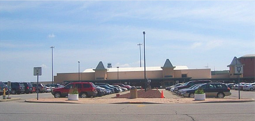
In July 2006, the state formally transferred ownership of the state forest from DOT to DEC, ending the process of creating Stewart State Forest. However, Orange County was not thrilled with the state's decision to charge it $3.7 million for the area near the exit, saying that it was too much on top of the costs it would incur putting in infrastructure. DOT says it's just asking fair market value for the land. NEG ManagementNEG's marketing initiatives included several proposed new names for the airport to emphasize its proximity to the city. The last one, in 2006, which would have dropped the "Stewart" name entirely, met with local opposition and was ultimately dropped. Stewart has a limited selection of flights available and is relatively uncrowded most of the day. Some tenants have moved into nearby former military buildings, but most remain as unoccupied as they were the day the base was closed down. It has drawn some passengers from western Connecticut who might otherwise have flown out of Hartford. But most of the fliers within Stewart's catchment area have continued to prefer Albany International Airport, Newark or other metropolitan airports, despite higher fares. Delta pulled out of the airport shortly after the privatization announcement, ostensibly to better serve new routes it had won to Latin America, leaving it to codeshare partners Comair and ASA. Even one of the "tourist draws" for the airport evaporated in 2003 when the Concorde was grounded. Its pilots had used the lengthy runway to practice touch-and-goes. NEG's dealings with the state were not as harmonious as they were initially represented; documents made public by SPARC after the privatization was completed showed that there were many lingering issues between the two parties even at that time and that NEG had in fact considered breaking the deal at one point (as it would later ultimately do). The company has gone through some local management shuffles as well, and the parent corporation's sale of East Midlands, considered the example it would follow with Stewart, was a cause for concern in the region. While some local officials expressed disappointment, others saw NEG as getting out of the airport business entirely to concentrate on its core business in the bus and rail sectors. They hoped at first that another European company with experience running privatized airports would be interested, and industry analysts said the timing was good. Governor Elliot Spitzer promised area leaders that Stewart would be a top priority for his administration, and the Port Authority of New York and New Jersey, which runs the New York area's three main airports, expressed interest in assuming NEG's obligations. Allegiant Air's pullout in early 2007 was actually seen as a good sign since that airline only flies where it doesn't face competition from AirTran Airways and JetBlue, both of which announced plans for service from Stewart. Port Authority takeover and end of privatizationOn January 25, 2007 the Port Authority voted to buy the lease for Stewart. It took over operating control on November 1, 2007, after New Jersey's acting governor Richard Codey signed a bill the New Jersey Legislature had to pass, changing the law to allow the move. The PA will pay NEG $78.5 million for the remaining 93 years on its lease. The day after the takeover, an opening ceremony was held in which New York State Governor Elliot Spitzer attended and the Port Authority flag was raised. It has set aside $500 million in its ten-year capital improvement plan to expand the airport. Airlines and destinations
Status and expansionAlthough 2006's bad numbers may have led NEG to pull out, Stewart's commercial service is currently on the rise, and passengers today can take advantage of low fares and popular routes that have never existed in the Hudson Valley before. For the first time in Stewart's history, cheap and competitive nonstop routes to destinations such as Orlando and Fort Lauderdale are in place and doing very well. Shortly after taking over, the PA reported that the airport's traffic for 2007 would be triple that of 2006. It was reported in January 2008 that Stewart had achieved its goal and had handled 970,000 passengers in 2007. A plan is currently in place to drastically change Stewart's image over the next 20 years. The plan includes major renovations such as the addition of a brand new terminal, the construction of a train station adjacent to the new terminal and connecting the airport to Metro North, a 2,000-foot (608 m) extension of runway 16-34, the addition of multiple new taxiways, and a major expansion of the cargo facilities at Stewart. Parts of the plan have already been put into place with the addition of a new control tower. In the fourth quarter of 2007, Interstate 84's new Drury Lane exit, NY Route 747, and International Boulevard were also opened. In addition to commercial and passenger services, Stewart excels in many other areas not seen as well by the public. NEG had some success selling private helicopter shuttle service to midtown Manhattan's heliports to business travelers from Stewart at rates competitive with those offered from JFK Airport; it also remains a popular place to service corporate jets due to the large space available. Cargo services are also part of the mix — Federal Express maintains a large distribution presence just outside the airport, as does the U.S. Postal Service, whose main general-mail facility for the mid-Hudson region is not far away, either. Importers of plant and animal products also route their flights to Stewart and the USDA inspection facility for those is nearby, on Drury Lane. In 2005, the airport was used to transport emergency personnel and supplies to help the cleanup after the destruction of Hurricane Katrina, which devastated the Gulf Coast. Stewart also serves as a popular divert destination for aircraft intending to land at one of the three main New York-area airports (Newark, LaGuardia, and JFK), especially during times of deteriorated weather in the city area. American Airlines, which had served Stewart since 1990, discontinued American Eagle regional jet service to Chicago O'Hare International Airport on September 5, 2007. In 2008, AirTran Airways announced it was discontinuing service at Stewart International Airport. The Port Authority sees Stewart as offering needed relief to those airports and (especially) Teterboro, estimating it could handle five times its present passenger volume. It will probably follow its standard procedure and contract the actual operations of the airport out. In February 2008, the PA's new general manager, Diannae Ehler, said she had been discussing the possibility of foreign flights with a number of European carriers. She felt encouraged and hoped that by 2009 there could be regular passenger service between Stewart and some European destinations.
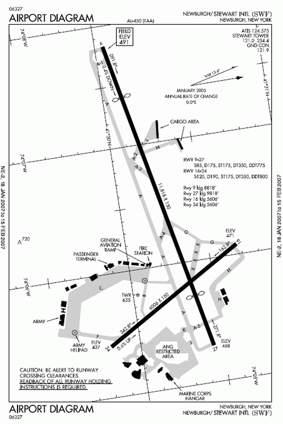
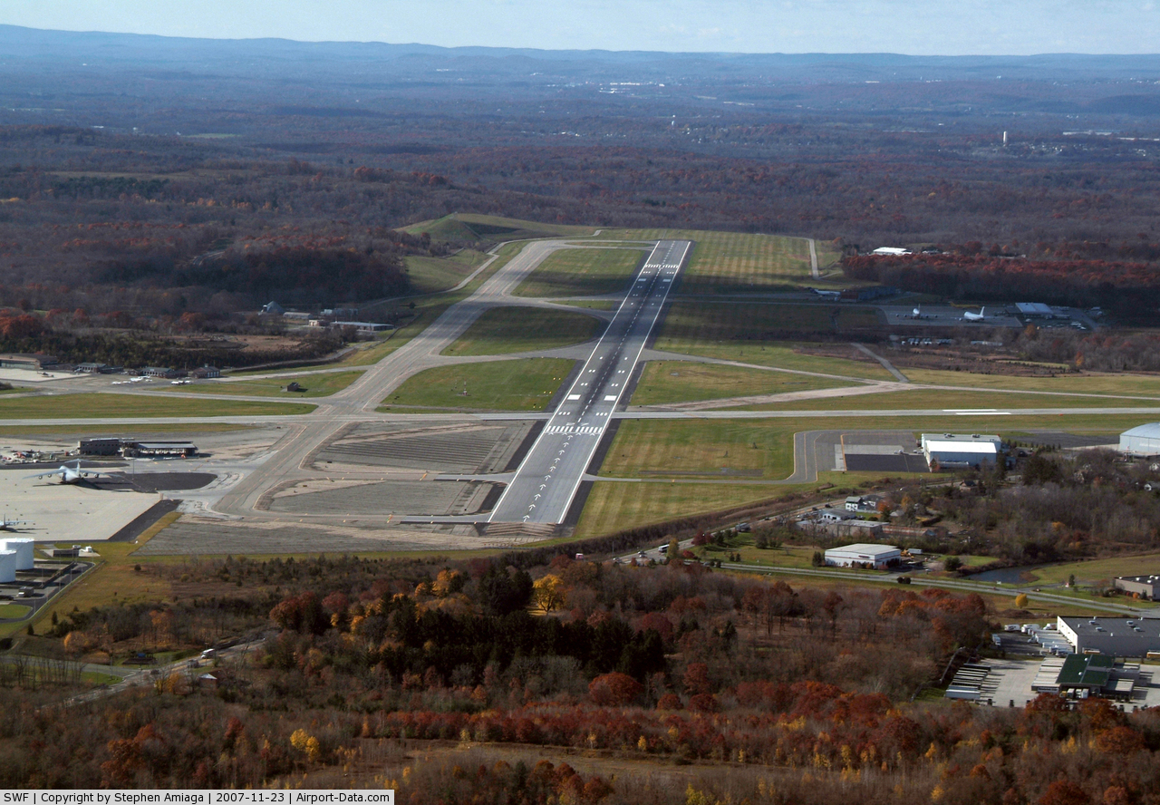
FacilitiesThe main east-west runway is 11,818 feet (3,602 m) long by 150 feet (46 m) wide, but the landing threshold in each direction is displaced 2000 feet (610 m). Additionally, aircraft landing to the east on runway 9 are involved with landing distance available restriction of an additional 1,000-foot (305 m) reduction in length, making only 8,818 feet (2,688 m) usable for landing. Runway 27 has 9,818 feet (2,993 m) available for landing. The full length of the runway is available for takeoff in both directions. Runway 9, the east-facing runway, is equipped with an instrument landing system for both category one and category two approaches. Runway 9 is also equipped with an ALSF2 approach lighting system. Runway 27 acquired an instrument landing system in much more recent years, but without any approach lighting, landing minimums for this runway require more visibility. The crosswind runway 16-34 is 6,006 feet (1,831 m) long by 150 feet (46 m) wide and each end has GPS-based instrument approaches. AccessOne of the biggest impediments to the use of Stewart by more airlines and passengers has long been the difficulty of actually getting to it. The completion of the Drury Lane exit in 2007 and the accompanying access road to the airport, International Boulevard, are intended to remedy this. In addition to road access, there have been plans over the years to possibly implement a light rail connection along Broadway in the city of Newburgh that could conceivably go out to Stewart from the ferry connection with the Metro-North passenger line across the Hudson River in Beacon; however that does not appear likely to happen anytime soon. Currently, the only connection is via a shuttle bus. In 2006, with construction of the Drury Lane exit underway, Senator Charles Schumer put his weight behind getting federal aid for another long-discussed access improvement: a rail link to the nearby Metro North Port Jervis Line, to give passengers an express train trip from the airport into the city or Newark Airport via Secaucus Junction. This would entail acquiring property and laying new tracks, to link to the existing line somewhere near the Salisbury Mills station. NEG had had success with the similar Gatwick Express and Midland Mainline rail-air connections in its native Britain. While the federal government has approved the idea, the money has not yet been appropriated. Accidents and incidentsIn the early morning hours of September 5, 1996, the pilots of a Federal Express DC-10 on its way from Memphis to Boston reported smoke in the cargo compartment and made an emergency landing at Stewart to fight the fire. All five crewmembers escaped with only minor injuries but, despite a prompt effort by the firefighting teams from the ANG base (which also handle the civilian airport's fire protection needs) the aircraft was completely destroyed. Two years later, the National Transportation Safety Board (NTSB) traced the source of the fire to an area where some flammables had been stored but could not pin down exactly which had combusted, and faulted the captain for failing to get full information on potentially hazardous materials being shipped. Early on the morning of November 21, 2007, a single-engine Cirrus piloted by Brian Early of Wayne, Pennsylvania got lost in the fog on its approach and crashed in the state forest. He had been dropping off his two passengers, a son and one of his friends, to visit friends of theirs at West Point for Thanksgiving. It took rescuers three hours to find the wreckage using the plane's transponder. Early was killed but the younger men survived. The above content comes from Wikipedia and is published under free licenses – click here to read more.
Location & QuickFacts
Owner & Manager
Airport Operations and Facilities
Airport Communications
Airport Services
Runway InformationRunway 09/27
Runway 16/34
Helipad H1
Radio Navigation Aids
Remarks
Images and information placed above are from We thank them for the data!
We don't guarantee the information is fresh and accurate. The data may
be wrong or outdated.
|
||||||||||||||||||||||||||||||||||||||||||||||||||||||||||||||||||||||||||||||||||||||||||||||||||||||||||||||||||||||||||||||||||||||||||||||||||||||||||||||||||||||||||||||||||||||||||||||||||||||||||||||||||||||||||||||||||||||||||||||||||||||||||||||||||||||||||||||||||||||||||||||||||||||||||||||||||||||||||||||||||||||||||||||||||||||||||||||||||||||||||||||||||||||||||||||||||||||||||||||||||||||||||||||||||||||||||||||||||||||

 |
|
Copyright 2004-2026 © by Airports-Worldwide.com, Vyshenskoho st. 36, Lviv 79010, Ukraine Legal Disclaimer |