 |
|
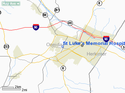
St Luke's Memorial Hospital Heliport |
Location & QuickFacts
| FAA Information Effective: | 2008-09-25 |
| Airport Identifier: | NK34 |
| Airport Status: | Operational |
| Longitude/Latitude: | 075-16-34.5970W/43-05-46.2500N
-75.276277/43.096181 (Estimated) |
| Elevation: | 575 ft / 175.26 m (Estimated) |
| Land: | 0 acres |
| From nearest city: | 1 nautical miles W of Utica, NY |
| Location: | Oneida County, NY |
| Magnetic Variation: | 13W (1985) |
Owner & Manager
| Ownership: | Privately owned |
| Owner: | Faxton-st Luke's Healthcare |
| Address: | Po Box 479
Utica, NY 13503 |
| Phone number: | 315-798-6000 |
| Manager: | Steven J. Brown |
| Address: | Po Box 479
Utica, NY 13503 |
| Phone number: | 315-798-6000 |
Airport Operations and Facilities
| Airport Use: | Private
MEDICAL USE. |
| Wind indicator: | Yes |
| Segmented Circle: | No |
| Control Tower: | No |
| Lighting Schedule: | PHONE REQ
FOR ROTG BCN & PERIMETER LIGHTS CALL 315-798-6000. |
| Beacon Color: | Clear-Green-Yellow (heliport) |
| Landing fee charge: | No |
| Sectional chart: | New York |
| Region: | AEA - Eastern |
| Boundary ARTCC: | ZBW - Boston |
| Tie-in FSS: | BUF - Buffalo |
| FSS on Airport: | No |
| FSS Toll Free: | 1-800-WX-BRIEF |
Runway Information
Helipad H1
| Dimension: | 60 x 60 ft / 18.3 x 18.3 m |
| Surface: | ASPH, Good Condition |
| |
Runway H1 |
Runway |
| Traffic Pattern: | Left | Left |
|
Radio Navigation Aids
| ID |
Type |
Name |
Ch |
Freq |
Var |
Dist |
| CJY | NDB | Clay | | 275.00 | 12W | 2.7 nm |
| BK | NDB | Plein | | 329.00 | 12W | 11.8 nm |
| JJH | NDB | Johnstown | | 523.00 | 14W | 41.9 nm |
| GSS | TACAN | Griffiss | 057X | | 12W | 10.1 nm |
| RKA | VOR/DME | Rockdale | 073X | 112.60 | 11W | 37.9 nm |
| UCA | VORTAC | Utica | 049X | 111.20 | 12W | 6.5 nm |
| GGT | VORTAC | Georgetown | 125X | 117.80 | 11W | 30.5 nm |
| SYR | VORTAC | Syracuse | 117X | 117.00 | 11W | 40.9 nm |
Remarks
- PRVDD LNDG AREA IS MOVED 20' TO THE NW.
Images and information placed above are from
http://www.airport-data.com/airport/NK34/
We thank them for the data!
| General Info
|
| Country |
United States
|
| State |
NEW YORK
|
| FAA ID |
NK34
|
| Latitude |
43-05-46.250N
|
| Longitude |
075-16-34.597W
|
| Elevation |
575 feet
|
| Near City |
UTICA
|
We don't guarantee the information is fresh and accurate. The data may
be wrong or outdated.
For more up-to-date information please refer to other sources.
|
|


