 |
|
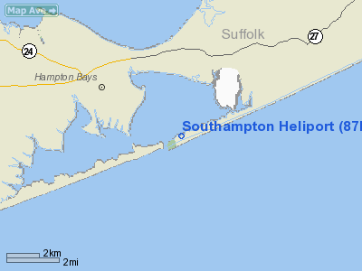
| Southampton Heliport |
| IATA: none – ICAO: none – FAA LID: 87N |
| Summary |
| Airport type |
Public |
| Owner |
The Incorporated Village of Southampton |
| Operator |
Mac Quarie Aviation |
| Serves |
Southampton |
| Location |
Southampton, New York |
| Coordinates |
40°50′46″N 72°27′59″W / 40.846236°N 72.466363°W / 40.846236; -72.466363Coordinates: 40°50′46″N 72°27′59″W / 40.846236°N 72.466363°W / 40.846236; -72.466363 |
| Helipads |
| Number |
Length |
Surface |
| ft |
m |
| 1 |
44 |
13 |
Asphalt |
| Source: Airnav: |
Southampton Heliport (FAA LID: 87N) is a heliport in Southampton, New York.
Operations
Southampton Heliport is located near the western end of the Meadow Lane (Beach Road/Dune Road) peninsula. It is used in the summer by the wealthy to travel from Manhattan to their summer homes in The Hamptons.
The above content comes from Wikipedia and is published under free licenses – click here to read more.
Location & QuickFacts
| FAA Information Effective: | 2008-09-25 |
| Airport Identifier: | 87N |
| Airport Status: | Operational |
| Longitude/Latitude: | 072-27-50.3160W/40-50-50.3610N
-72.463977/40.847323 (Estimated) |
| Elevation: | 5 ft / 1.52 m (Surveyed) |
| Land: | 0 acres |
| From nearest city: | 4 nautical miles SW of Southampton, NY |
| Location: | Suffolk County, NY |
| Magnetic Variation: | 14W (1985) |
Owner & Manager
| Ownership: | Publicly owned |
| Owner: | Village Of Southampton |
| Address: | 23 Main St
Southampton, NY 11968 |
| Phone number: | 516-283-0247 |
| Manager: | James Van Ostrand
OR BOB GRISNIK 516-283-1506. |
| Address: | 23 Main St
Southampton, NY 11968 |
Airport Operations and Facilities
| Airport Use: | Open to public |
| Wind indicator: | Yes |
| Segmented Circle: | No |
| Control Tower: | No |
| Sectional chart: | New York |
| Region: | AEA - Eastern |
| Boundary ARTCC: | ZBW - Boston |
| Responsible ARTCC: | ZNY - New York |
| Tie-in FSS: | ISP - New York |
| FSS on Airport: | No |
| FSS Toll Free: | 1-800-WX-BRIEF |
| NOTAMs Facility: | ISP (NOTAM-d service avaliable) |
Airport Communications
Runway Information
Helipad H1
| Dimension: | 44 x 44 ft / 13.4 x 13.4 m |
| Surface: | ASPH, |
| |
Runway H1 |
Runway |
| Traffic Pattern: | Left | Left |
| Markings: | Basic, Good Condition | , |
|
Radio Navigation Aids
| ID |
Type |
Name |
Ch |
Freq |
Var |
Dist |
| OP | NDB | Old Field Point Light | | 316.00 | 13W | 30.7 nm |
| MMK | NDB | Meriden | | 238.00 | 14W | 43.1 nm |
| BBN | NDB | Babylon | | 275.00 | 14W | 43.2 nm |
| HF | NDB | Lomis | | 244.00 | 15W | 47.9 nm |
| FOK | TACAN | Suffolk Co | 047X | | 13W | 7.7 nm |
| CCC | VOR/DME | Calverton | 119X | 117.20 | 13W | 16.0 nm |
| MAD | VOR/DME | Madison | 041X | 110.40 | 13W | 29.9 nm |
| HVN | VOR/DME | New Haven | 035X | 109.80 | 13W | 31.4 nm |
| GON | VOR/DME | Groton | 45Y | 110.85 | 14W | 34.5 nm |
| BDR | VOR/DME | Bridgeport | 25X | 108.80 | 12W | 35.4 nm |
| DPK | VOR/DME | Deer Park | 124X | 117.70 | 12W | 38.3 nm |
| SEY | VOR/DME | Sandy Point | 125X | 117.80 | 15W | 44.6 nm |
| ORW | VOR/DME | Norwich | 037X | 110.00 | 14W | 47.5 nm |
| HFD | VOR/DME | Hartford | 096X | 114.90 | 13W | 47.9 nm |
| HTO | VORTAC | Hampton | 083X | 113.60 | 13W | 8.0 nm |
| ISP | VOT | Long Island Mac Arthur | | 109.40 | | 28.9 nm |
| GON | VOT | Groton | | 110.25 | | 34.3 nm |
| BDR | VOT | Bridgeport | | 109.25 | | 35.5 nm |
Remarks
- NOISE SENSITIVE AREA DUE TO HOUSES NEARBY.
- NO IDLING OR WAITING ON HELIPAD PERMITTED.
Images and information placed above are from
http://www.airport-data.com/airport/87N/
We thank them for the data!
| General Info
|
| Country |
United States
|
| State |
NEW YORK
|
| FAA ID |
87N
|
| Latitude |
40-50-50.361N
|
| Longitude |
072-27-50.316W
|
| Elevation |
5 feet
|
| Near City |
SOUTHAMPTON
|
We don't guarantee the information is fresh and accurate. The data may
be wrong or outdated.
For more up-to-date information please refer to other sources.
|
|


