 |
|
| Sky Park Airport |
| IATA: none – ICAO: none – FAA LID: 46N |
| Summary |
| Airport type |
Public |
| Owner |
Eli Cohn |
| Serves |
Red Hook, New York |
| Elevation AMSL |
323 ft / 98 m |
| Coordinates |
41°59′04″N 073°50′09″W / 41.98444°N 73.83583°W / 41.98444; -73.83583Coordinates: 41°59′04″N 073°50′09″W / 41.98444°N 73.83583°W / 41.98444; -73.83583 |
| Runways |
| Direction |
Length |
Surface |
| ft |
m |
| 1/19 |
2,664 |
812 |
Asphalt |
| Statistics (2005) |
| Aircraft operations |
235 |
| Source: Federal Aviation Administration |
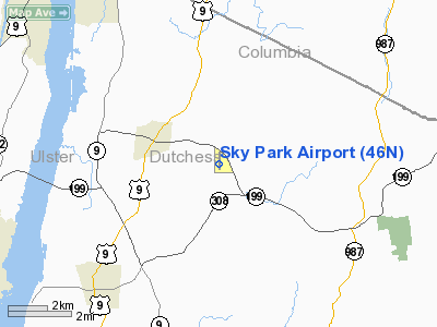
Sky Park Airport (FAA LID: 46N) is a public use airport located two nautical miles (4 km) east of the central business district of Red Hook, a town in Dutchess County, New York, United States. It is privately owned by Eli Cohn.
Facilities and aircraft
Sky Park Airport has one runway designated 1/19 with a 2,664 x 30 ft (812 x 9 m) asphalt surface. For the 12-month period ending September 9, 2005, the airport had 235 aircraft operations: 85% general aviation, 11% air taxi and 4% military.
The above content comes from Wikipedia and is published under free licenses – click here to read more.
Location & QuickFacts
| FAA Information Effective: | 2008-09-25 |
| Airport Identifier: | 46N |
| Airport Status: | Operational |
| Longitude/Latitude: | 073-50-09.4760W/41-59-04.5000N
-73.835966/41.984583 (Estimated) |
| Elevation: | 323 ft / 98.45 m (Surveyed) |
| Land: | 0 acres |
| From nearest city: | 2 nautical miles E of Red Hook, NY |
| Location: | Dutchess County, NY |
| Magnetic Variation: | 12W (1970) |
Owner & Manager
| Ownership: | Privately owned |
| Owner: | Eli Cohn |
| Address: |
|
| Phone number: | (845) 642-6011. |
| Address: |
|
Airport Operations and Facilities
| Airport Use: | Open to public |
| Wind indicator: | Yes |
| Segmented Circle: | No |
| Control Tower: | No |
| Landing fee charge: | No
|
| Sectional chart: | New York |
| Region: | AEA - Eastern |
| Boundary ARTCC: | ZBW - Boston |
| Responsible ARTCC: | ZNY - New York |
| Tie-in FSS: | ISP - New York |
| FSS Toll Free: | 1-800-WX-BRIEF |
| NOTAMs Facility: | ISP (NOTAM-d service avaliable) |
| Federal Agreements: | N |
Airport Communications
Airport Services
| Airframe Repair: | NONE |
| Power Plant Repair: | NONE |
Runway Information
Runway 01/19
| Dimension: | 2664 x 30 ft / 812.0 x 9.1 m |
| Surface: | ASPH, Poor Condition
PAVEMENT HAS SMALL POTHOLES & LOOSE AGGREGATE. |
| Weight Limit: | Single wheel: 30000 lbs. |
| |
Runway 01 |
Runway 19 |
| Longitude: | 073-50-09.8441W | 073-50-09.2609W |
| Latitude: | 41-58-51.6653N | 41-59-17.9810N |
| Elevation: | 323.00 ft | 316.00 ft |
| Alignment: | 1 | 127 |
| Traffic Pattern: | Left | Left |
| Runway End Identifier: | No | No |
| Centerline Lights: | No | No |
| Touchdown Lights: | No | No |
| Obstruction: | 45 ft trees, 200.0 ft from runway, 80 ft right of centerline
RY 01 +45 FT TREES 0-200 FT FM THLD LEFT & RIGHT. | 20 ft trees, 200.0 ft from runway, 40 ft left of centerline
+10 FT TREES 40 FT L & R OF CNTRLN 0-200 FT FM THLD. |
|
Radio Navigation Aids
| ID |
Type |
Name |
Ch |
Freq |
Var |
Dist |
| GBR | FAN MARKER | Sheffield | | | 13W | 22.8 nm |
| SKU | FAN MARKER | Stanwyck | | | 12W | 29.0 nm |
| PSF | FAN MARKER | Abyss | | | 13W | 39.6 nm |
| PFH | NDB | Philmont | | 272.00 | 13W | 16.9 nm |
| GBR | NDB | Great Barrington | | 395.00 | 14W | 22.7 nm |
| PO | NDB | Meier | | 403.00 | 12W | 25.3 nm |
| SKU | NDB | Stanwyck | | 261.00 | 12W | 29.0 nm |
| SW | NDB | Neely | | 335.00 | 14W | 34.8 nm |
| TBY | NDB | Waterbury | | 257.00 | 14W | 41.4 nm |
| DXT | NDB | Dalton | | 370.00 | 15W | 41.6 nm |
| MS | NDB | Monga | | 359.00 | 12W | 47.7 nm |
| PWL | VOR/DME | Pawling | 090X | 114.30 | 12W | 16.7 nm |
| IGN | VOR/DME | Kingston | 123X | 117.60 | 12W | 19.2 nm |
| CTR | VOR/DME | Chester | 098X | 115.10 | 13W | 43.6 nm |
| CMK | VOR/DME | Carmel | 113X | 116.60 | 12W | 43.9 nm |
| HUO | VOR/DME | Huguenot | 108X | 116.10 | 11W | 48.4 nm |
| ALB | VORTAC | Albany | 100X | 115.30 | 13W | 45.9 nm |
| ALB | VOT | Albany County | | 108.20 | | 45.5 nm |
Remarks
- RY SAFETY AREAS HAVE DROPOFFS & ROUGH TERRAIN.
- PARALLEL TWY CONSTRUCTED OF DIRT & GRVL.
- TREES WITHIN 20 FT OF CNTRLN EAST SIDE OF PARALLEL TWY SOUTH OF MIDPOINT.
- CALL AT LEAST THREE (3) HOURS PRIOR MINIMUM FOR PPR AT 845-352-3924.
- EXISTED PRIOR TO 1959.
Images and information placed above are from
http://www.airport-data.com/airport/46N/
We thank them for the data!
| General Info
|
| Country |
United States
|
| State |
NEW YORK
|
| FAA ID |
46N
|
| Latitude |
41-59-04.500N
|
| Longitude |
073-50-09.476W
|
| Elevation |
323 feet
|
| Near City |
RED HOOK
|
We don't guarantee the information is fresh and accurate. The data may
be wrong or outdated.
For more up-to-date information please refer to other sources.
|
|


