 |
|
Coordinates: 41°42′27″N 073°44′17″W / 41.7075°N 73.73806°W / 41.7075; -73.73806
| Sky Acres Airport |
| IATA: none – ICAO: none – FAA LID: 44N |
| Summary |
| Airport type |
Public |
| Owner |
Sky Acres Enterprises, Inc. |
| Serves |
Millbrook, New York |
| Elevation AMSL |
698 ft / 213 m |
| Runways |
| Direction |
Length |
Surface |
| ft |
m |
| 17/35 |
3,830 |
1,167 |
Asphalt |
| Statistics (2005) |
| Aircraft operations |
48,300 |
| Based aircraft |
95 |
| Source: Federal Aviation Administration |
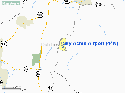
Sky Acres Airport (FAA LID: 44N) is a public-use airport located six miles (10 km) southwest of the central business district of Millbrook, a village in Dutchess County, New York, United States. It is privately owned by Sky Acres Enterprises, Inc.
Facilities and aircraft
Sky Acres Airport covers an area of 205 acres (83 ha) and contains one runway designated 17/35 with a 3,830 x 60 ft (1,167 x 18 m) asphalt pavement. For the 12-month period ending September 15, 2005, the airport had 48,300 aircraft operations, an average of 132 per day: 99% general aviation and 1% military. There are 95 aircraft based at this airport: 82% single-engine and 18% multi-engine.
The above content comes from Wikipedia and is published under free licenses – click here to read more.
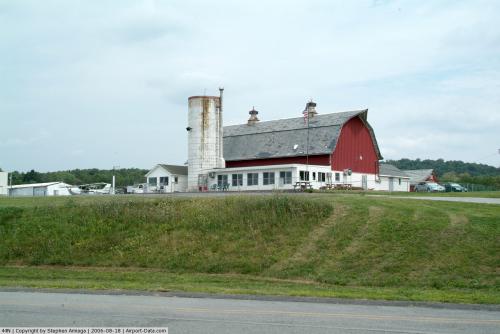 |
(Click on the photo to enlarge) |
Location & QuickFacts
| FAA Information Effective: | 2008-09-25 |
| Airport Identifier: | 44N |
| Airport Status: | Operational |
| Longitude/Latitude: | 073-44-16.9000W/41-42-26.7000N
-73.738028/41.707417 (Estimated) |
| Elevation: | 698 ft / 212.75 m (Estimated) |
| Land: | 205 acres |
| From nearest city: | 6 nautical miles SW of Millbrook, NY |
| Location: | Dutchess County, NY |
| Magnetic Variation: | 14W (2000) |
Owner & Manager
| Ownership: | Privately owned |
| Owner: | Sky Acres Enterprises, Inc. |
| Address: | 30 Airway Drive
Lagrangeville, NY 12540 |
| Phone number: | 914-204-0401 |
| Manager: | Ginnie Styles |
| Address: | 30 Airway Drive
Lagrangeville, NY 12540 |
| Phone number: | 845-677-5010 |
Airport Operations and Facilities
| Airport Use: | Open to public |
| Wind indicator: | Yes |
| Segmented Circle: | No |
| Control Tower: | No |
| Lighting Schedule: | RDO-CTL
ACTVT MIRL RY 17/35 & PAPI RY 35 - 122.8. |
| Landing fee charge: | No |
| Sectional chart: | New York |
| Region: | AEA - Eastern |
| Boundary ARTCC: | ZBW - Boston |
| Responsible ARTCC: | ZNY - New York |
| Tie-in FSS: | ISP - New York |
| FSS on Airport: | No |
| FSS Toll Free: | 1-800-WX-BRIEF |
| NOTAMs Facility: | ISP (NOTAM-d service avaliable) |
| Federal Agreements: | NGY |
Airport Communications
| CTAF: | 122.800 |
| Unicom: | 122.800 |
Airport Services
| Fuel available: | 100LL
SELF-SVC FUEL AVBL 24/7. |
| Airframe Repair: | MAJOR |
| Power Plant Repair: | MAJOR |
Runway Information
Runway 17/35
| Dimension: | 3830 x 60 ft / 1167.4 x 18.3 m |
| Surface: | ASPH, Good Condition |
| Weight Limit: | Single wheel: 20000 lbs. |
| Edge Lights: | Medium |
| |
Runway 17 |
Runway 35 |
| Longitude: | 073-44-28.4027W | 073-44-05.3571W |
| Latitude: | 41-42-43.5590N | 41-42-09.8954N |
| Elevation: | 646.00 ft | 697.00 ft |
| Alignment: | 127 | 127 |
| Traffic Pattern: | Left | Left |
| VASI: | | 4-light PAPI on left side
PAPI OTS INDEFLY. |
| Runway End Identifier: | No | No |
| Centerline Lights: | No | No |
| Touchdown Lights: | No | No |
| Obstruction: | 5 ft trees, 200.0 ft from runway, 80 ft right of centerline
RY 17 +5 FT TREE, DIST 200 FT, 80 FT RIGHT. | 29 ft tree, 525.0 ft from runway, 200 ft right of centerline, 11:1 slope to clear
RY 35 +3 FT TREE, DIST 145 FT FM THLD, 125 FT RIGHT. |
|
Radio Navigation Aids
| ID |
Type |
Name |
Ch |
Freq |
Var |
Dist |
| SKU | FAN MARKER | Stanwyck | | | 12W | 17.5 nm |
| GBR | FAN MARKER | Sheffield | | | 13W | 30.3 nm |
| PO | NDB | Meier | | 403.00 | 12W | 12.9 nm |
| SKU | NDB | Stanwyck | | 261.00 | 12W | 17.5 nm |
| SW | NDB | Neely | | 335.00 | 14W | 25.7 nm |
| TBY | NDB | Waterbury | | 257.00 | 14W | 28.8 nm |
| GBR | NDB | Great Barrington | | 395.00 | 14W | 32.3 nm |
| PFH | NDB | Philmont | | 272.00 | 13W | 32.8 nm |
| MMK | NDB | Meriden | | 238.00 | 14W | 42.6 nm |
| PNJ | NDB | Paterson | | 347.00 | 12W | 49.4 nm |
| IGN | VOR/DME | Kingston | 123X | 117.60 | 12W | 4.5 nm |
| PWL | VOR/DME | Pawling | 090X | 114.30 | 12W | 7.2 nm |
| CMK | VOR/DME | Carmel | 113X | 116.60 | 12W | 26.6 nm |
| HUO | VOR/DME | Huguenot | 108X | 116.10 | 11W | 42.4 nm |
| BDR | VOR/DME | Bridgeport | 25X | 108.80 | 12W | 42.9 nm |
| HVN | VOR/DME | New Haven | 035X | 109.80 | 13W | 46.8 nm |
| CTR | VOR/DME | Chester | 098X | 115.10 | 13W | 49.7 nm |
| BDL | VORTAC | Bradley | 027X | 109.00 | 14W | 49.1 nm |
| BDR | VOT | Bridgeport | | 109.25 | | 42.9 nm |
| HFD | VOT | Hartford | | 108.20 | | 48.8 nm |
| BDL | VOT | Bradley Intl | | 111.40 | | 49.3 nm |
Remarks
- RY 17/35 SAFETY AREAS HAVE 30 FT DROPOFFS SLOPING 20 FT FM THLD AT BOTH ENDS.
- PARALLEL TWY NOT LGTD.
Images and information placed above are from
http://www.airport-data.com/airport/44N/
We thank them for the data!
| General Info
|
| Country |
United States
|
| State |
NEW YORK
|
| FAA ID |
44N
|
| Latitude |
41-42-26.743N
|
| Longitude |
073-44-16.904W
|
| Elevation |
700 feet
|
| Near City |
MILLBROOK
|
We don't guarantee the information is fresh and accurate. The data may
be wrong or outdated.
For more up-to-date information please refer to other sources.
|
|


