 |
|
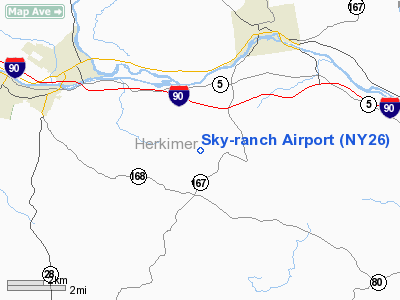
Location & QuickFacts
| FAA Information Effective: | 2008-09-25 |
| Airport Identifier: | NY26 |
| Airport Status: | Operational |
| Longitude/Latitude: | 074-53-58.5480W/42-59-00.2550N
-74.899597/42.983404 (Estimated) |
| Elevation: | 1330 ft / 405.38 m (Estimated) |
| Land: | 0 acres |
| From nearest city: | 5 nautical miles SE of Herkimer, NY |
| Location: | Herkimer County, NY |
| Magnetic Variation: | 13W (1985) |
Owner & Manager
| Ownership: | Privately owned |
| Owner: | Lester Savage |
| Address: | 542 Berdan Avenue
Wayne, NJ 07470 |
| Phone number: | 201-696-0954 |
| Manager: | Lester Savage |
| Address: | 542 Berdan Ave
Wayne, NJ 07470 |
| Phone number: | 201-696-0954 |
Airport Operations and Facilities
| Airport Use: | Private |
| Wind indicator: | Yes |
| Segmented Circle: | No |
| Control Tower: | No |
| Landing fee charge: | No |
| Sectional chart: | New York |
| Region: | AEA - Eastern |
| Boundary ARTCC: | ZBW - Boston |
| Tie-in FSS: | BUF - Buffalo |
| FSS on Airport: | No |
| FSS Toll Free: | 1-800-WX-BRIEF |
Airport Services
Runway Information
Runway 11/29
| Dimension: | 2141 x 60 ft / 652.6 x 18.3 m |
| Surface: | TURF, Poor Condition |
| |
Runway 11 |
Runway 29 |
| Traffic Pattern: | Left | Left |
| Runway End Identifier: | | Yes |
| Centerline Lights: | No | No |
| Obstruction: | 4 ft fence, 4.0 ft from runway, 1:1 slope to clear | 15 ft road, 21.0 ft from runway, 1:1 slope to clear |
|
Radio Navigation Aids
| ID |
Type |
Name |
Ch |
Freq |
Var |
Dist |
| CJY | NDB | Clay | | 275.00 | 12W | 16.6 nm |
| JJH | NDB | Johnstown | | 523.00 | 14W | 25.0 nm |
| BK | NDB | Plein | | 329.00 | 12W | 29.3 nm |
| HEU | NDB | Hunter | | 356.00 | 14W | 43.2 nm |
| GSS | TACAN | Griffiss | 057X | | 12W | 27.0 nm |
| RKA | VOR/DME | Rockdale | 073X | 112.60 | 11W | 34.5 nm |
| DNY | VOR/DME | De Lancey | 058X | 112.10 | 11W | 48.5 nm |
| UCA | VORTAC | Utica | 049X | 111.20 | 12W | 11.9 nm |
| GGT | VORTAC | Georgetown | 125X | 117.80 | 11W | 42.5 nm |
| ALB | VOT | Albany County | | 108.20 | | 49.6 nm |
Remarks
- DEER INVOF RY DURG SUMMER MONTHS.
- A COMNS TWR IS LCTD APROX 600' L OF RY 11. MAY BE AN OBSTN FOR THE DWND APCH LEG FOR RY 11.
- EXISTED PRIOR TO 1959.
Images and information placed above are from
http://www.airport-data.com/airport/NY26/
We thank them for the data!
| General Info
|
| Country |
United States
|
| State |
NEW YORK
|
| FAA ID |
NY26
|
| Latitude |
42-59-00.255N
|
| Longitude |
074-53-58.548W
|
| Elevation |
1330 feet
|
| Near City |
HERKIMER
|
We don't guarantee the information is fresh and accurate. The data may
be wrong or outdated.
For more up-to-date information please refer to other sources.
|
|


