 |
|
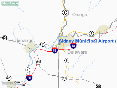
Location & QuickFacts
| FAA Information Effective: | 2008-09-25 |
| Airport Identifier: | N23 |
| Airport Status: | Operational |
| Longitude/Latitude: | 075-24-57.4430W/42-18-09.2880N
-75.415956/42.302580 (Estimated) |
| Elevation: | 1027 ft / 313.03 m (Surveyed) |
| Land: | 50 acres |
| From nearest city: | 1 nautical miles W of Sidney, NY |
| Location: | Delaware County, NY |
| Magnetic Variation: | 13W (2000) |
Owner & Manager
| Ownership: | Publicly owned |
| Owner: | Village Of Sidney |
| Address: | 21 Liberty St.
Sidney, NY 13838 |
| Phone number: | 607-561-2346 |
| Manager: | James V. Roberts |
| Address: | 199 River St
Sidney, NY 13838 |
| Phone number: | 607-561-2346 |
Airport Operations and Facilities
| Airport Use: | Open to public |
| Wind indicator: | Yes |
| Segmented Circle: | Yes |
| Control Tower: | No |
| Lighting Schedule: | DUSK-DAWN
ACTVT MIRL RY 07/25 & REIL RYS 07 & 25 - CTAF. |
| Beacon Color: | Clear-Green (lighted land airport) |
| Landing fee charge: | No |
| Sectional chart: | New York |
| Region: | AEA - Eastern |
| Boundary ARTCC: | ZBW - Boston |
| Tie-in FSS: | BUF - Buffalo |
| FSS on Airport: | No |
| FSS Toll Free: | 1-800-WX-BRIEF |
| NOTAMs Facility: | BUF (NOTAM-d service avaliable) |
| Federal Agreements: | NGY |
Airport Communications
| CTAF: | 122.800 |
| Unicom: | 122.800 |
Airport Services
| Fuel available: | 100LLA |
| Airframe Repair: | MAJOR |
| Power Plant Repair: | MAJOR |
| Bottled Oxygen: | HIGH/LOW |
| Bulk Oxygen: | NONE |
Runway Information
Runway 07/25
| Dimension: | 4204 x 75 ft / 1281.4 x 22.9 m |
| Surface: | ASPH, Good Condition |
| Weight Limit: | Single wheel: 25000 lbs.
Dual wheel: 45000 lbs. |
| Edge Lights: | Medium |
| |
Runway 07 |
Runway 25 |
| Longitude: | 075-25-21.1080W | 075-24-33.7620W |
| Latitude: | 42-17-58.2090N | 42-18-20.3330N |
| Elevation: | 1025.00 ft | 1022.00 ft |
| Alignment: | 58 | 127 |
| Traffic Pattern: | Left | Right |
| Markings: | Basic, Good Condition | Non-precision instrument, Good Condition |
| Crossing Height: | 0.00 ft | 42.00 ft |
| VASI: | | 2-light PAPI on right side |
| Visual Glide Angle: | 0.00° | 3.00° |
| Runway End Identifier: | Yes | Yes |
| Obstruction: | 53 ft tree, 512.0 ft from runway, 270 ft left of centerline, 5:1 slope to clear
+5 FT GND AT 160 FT RIGHT. | 5 ft road, 235.0 ft from runway, 260 ft right of centerline, 7:1 slope to clear |
|
Radio Navigation Aids
| ID |
Type |
Name |
Ch |
Freq |
Var |
Dist |
| MS | NDB | Monga | | 359.00 | 12W | 40.6 nm |
| CJY | NDB | Clay | | 275.00 | 12W | 45.6 nm |
| RKA | VOR/DME | Rockdale | 073X | 112.60 | 11W | 12.6 nm |
| HNK | VOR/DME | Hancock | 115X | 116.80 | 11W | 15.1 nm |
| DNY | VOR/DME | De Lancey | 058X | 112.10 | 11W | 21.7 nm |
| ITH | VOR/DME | Ithaca | 055X | 111.80 | 10W | 47.8 nm |
| CFB | VORTAC | Binghamton | 059X | 112.20 | 10W | 33.2 nm |
| GGT | VORTAC | Georgetown | 125X | 117.80 | 11W | 34.4 nm |
| UCA | VORTAC | Utica | 049X | 111.20 | 12W | 44.9 nm |
| LHY | VORTAC | Lake Henry | 045X | 110.80 | 10W | 49.8 nm |
Remarks
- NUMEROUS HILLS SURROUND ARPT UP TO +800 FT ABV ARPT ELEV.
- HIGH TENSION LINES +1 MI FROM AER 07.
- AWOS 118.275
- PUBLIC USE IAP PENDING.
Images and information placed above are from
http://www.airport-data.com/airport/N23/
We thank them for the data!
| General Info
|
| Country |
United States
|
| State |
NEW YORK
|
| FAA ID |
N23
|
| Latitude |
42-18-09.288N
|
| Longitude |
075-24-57.443W
|
| Elevation |
1027 feet
|
| Near City |
SIDNEY
|
We don't guarantee the information is fresh and accurate. The data may
be wrong or outdated.
For more up-to-date information please refer to other sources.
|
|


