 |
|
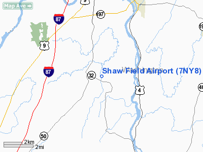
Location & QuickFacts
| FAA Information Effective: | 2008-09-25 |
| Airport Identifier: | 7NY8 |
| Airport Status: | Operational |
| Longitude/Latitude: | 073-37-47.4200W/43-11-32.2650N
-73.629839/43.192296 (Estimated) |
| Elevation: | 190 ft / 57.91 m (Estimated) |
| Land: | 4 acres |
| From nearest city: | 0 nautical miles N of Glen Falls, NY |
| Location: | Saratoga County, NY |
| Magnetic Variation: | 14W (1990) |
Owner & Manager
| Ownership: | Privately owned |
| Owner: | Franklin C. Shaw |
| Address: | 128 Kobor Rd
Gansevoort, NY |
| Phone number: | 518-793-2290 |
| Manager: | Franklin C. Shaw |
| Address: | 128 Kobor Rd
Gansevoort, NY |
| Phone number: | 518-793-2290 |
Airport Operations and Facilities
| Airport Use: | Private |
| Wind indicator: | Yes |
| Segmented Circle: | No |
| Control Tower: | No |
| Sectional chart: | New York |
| Region: | AEA - Eastern |
| Boundary ARTCC: | ZBW - Boston |
| Tie-in FSS: | BTV - Burlington |
| FSS on Airport: | No |
| FSS Toll Free: | 1-800-WX-BRIEF |
Airport Communications
Runway Information
Runway 17/35
| Dimension: | 1200 x 40 ft / 365.8 x 12.2 m |
| Surface: | DIRT-TURF, |
| |
Runway 17 |
Runway 35 |
| Traffic Pattern: | Left | Left |
|
Radio Navigation Aids
| ID |
Type |
Name |
Ch |
Freq |
Var |
Dist |
| R | FAN MARKER | Chitt | | | 14W | 39.2 nm |
| PSF | FAN MARKER | Abyss | | | 13W | 47.9 nm |
| HEU | NDB | Hunter | | 356.00 | 14W | 24.4 nm |
| JJH | NDB | Johnstown | | 523.00 | 14W | 32.9 nm |
| VWD | NDB | Mount Snow | | 224.00 | 15W | 37.2 nm |
| DYO | NDB | Smuto | | 221.00 | 15W | 42.6 nm |
| SXD | NDB | Springfield | | 265.00 | 15W | 45.9 nm |
| DXT | NDB | Dalton | | 370.00 | 15W | 47.9 nm |
| CAM | VOR/DME | Cambridge | 097X | 115.00 | 14W | 17.3 nm |
| RUT | VOR/DME | Rutland | 47X | 111.00 | 15W | 35.8 nm |
| GFL | VORTAC | Glens Falls | 039X | 110.20 | 14W | 9.0 nm |
| ALB | VORTAC | Albany | 100X | 115.30 | 13W | 27.8 nm |
| ALB | VOT | Albany County | | 108.20 | | 28.3 nm |
Remarks
- PRVDD NOTIFY MR. HEBER BY TELEPHONE WHEN OPNS OCCUR; BOTH ARPTS WOULD MONITOR 122.8 WHEN OPERATING; HEBER ARPT WOULD USE RIGHT HAND TFC PATTERN WHEN LNDG TO NW; SEGMENTED CIRCLE WILL BE CONSTRUCTED AT SHAW FIELD.
Images and information placed above are from
http://www.airport-data.com/airport/7NY8/
We thank them for the data!
| General Info
|
| Country |
United States
|
| State |
NEW YORK
|
| FAA ID |
7NY8
|
| Latitude |
43-11-32.265N
|
| Longitude |
073-37-47.420W
|
| Elevation |
190 feet
|
| Near City |
GLEN FALLS
|
We don't guarantee the information is fresh and accurate. The data may
be wrong or outdated.
For more up-to-date information please refer to other sources.
|
|


