 |
|
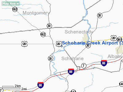
Location & QuickFacts
| FAA Information Effective: | 2008-09-25 |
| Airport Identifier: | 32NK |
| Airport Status: | Operational |
| Longitude/Latitude: | 074-18-40.0000W/42-45-12.0000N
-74.311111/42.753333 (Estimated) |
| Elevation: | 620 ft / 188.98 m () |
| Land: | 60 acres |
| From nearest city: | 3 nautical miles W of Esperance, NY |
| Location: | Schoharie County, NY |
| Magnetic Variation: | () |
Owner & Manager
| Ownership: | Privately owned |
| Owner: | Lloyd W. East Jr. |
| Address: | P. O. Box 2965
Glenville, NY 12325 |
| Phone number: | 518-369-9926 |
| Manager: | Lloyd W. East Jr. |
| Address: | P. O. Box 2965
Glenville, NY 12325 |
| Phone number: | 518-369-9926 |
Airport Operations and Facilities
| Airport Use: | Private |
| Wind indicator: | Yes |
| Control Tower: | No |
| Sectional chart: | New York |
| Region: | AEA - Eastern |
| Boundary ARTCC: | ZBW - Boston |
| Tie-in FSS: | BTV - Burlington |
| FSS Toll Free: | 1-800-WX-BRIEF |
Runway Information
Runway 07/25
| Dimension: | 1600 x 100 ft / 487.7 x 30.5 m |
| Surface: | TURF, |
| |
Runway 07 |
Runway 25 |
| Traffic Pattern: | Left | Left |
| Displaced threshold: | 0.00 ft | 400.00 ft |
| Obstruction: | | 30 ft trees, 300.0 ft from runway |
|
Radio Navigation Aids
| ID |
Type |
Name |
Ch |
Freq |
Var |
Dist |
| JJH | NDB | Johnstown | | 523.00 | 14W | 14.8 nm |
| HEU | NDB | Hunter | | 356.00 | 14W | 17.7 nm |
| PFH | NDB | Philmont | | 272.00 | 13W | 39.8 nm |
| CJY | NDB | Clay | | 275.00 | 12W | 45.7 nm |
| RKA | VOR/DME | Rockdale | 073X | 112.60 | 11W | 44.5 nm |
| DNY | VOR/DME | De Lancey | 058X | 112.10 | 11W | 44.9 nm |
| CAM | VOR/DME | Cambridge | 097X | 115.00 | 14W | 45.0 nm |
| ALB | VORTAC | Albany | 100X | 115.30 | 13W | 22.4 nm |
| UCA | VORTAC | Utica | 049X | 111.20 | 12W | 41.0 nm |
| GFL | VORTAC | Glens Falls | 039X | 110.20 | 14W | 46.8 nm |
| ALB | VOT | Albany County | | 108.20 | | 21.6 nm |
Remarks
- PRVDD DAYLGT OPNS; A CLEAR 20:1 APCH/DEP PATH OR DISPLACED THLD TO ACHIEVE; AND OPERATE IN AMANNER TO MINIMIZE NOISE.
Images and information placed above are from
http://www.airport-data.com/airport/32NK/
We thank them for the data!
|
|


