 |
|
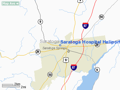
Saratoga Hospital Heliport |
Location & QuickFacts
| FAA Information Effective: | 2008-09-25 |
| Airport Identifier: | 7NK2 |
| Airport Status: | Operational |
| Longitude/Latitude: | 073-48-07.0600W/43-05-09.9100N
-73.801961/43.086086 (Estimated) |
| Elevation: | 379 ft / 115.52 m (Estimated) |
| Land: | 0 acres |
| From nearest city: | 1 nautical miles E of Saratoga Springs, NY |
| Location: | Saratoga County, NY |
| Magnetic Variation: | 14W (1995) |
Owner & Manager
| Ownership: | Privately owned |
| Owner: | Saratoga Hospital & Nursing Home |
| Address: | 211 Church St
Saratoga Springs, NY 12866 |
| Phone number: | 518-583-8640 |
| Manager: | Steve Frenchak |
| Address: | 211 Church St
Saratoga Springs, NY 12866 |
| Phone number: | 518-583-8640 |
Airport Operations and Facilities
| Airport Use: | Private |
| Wind indicator: | Yes |
| Segmented Circle: | No |
| Control Tower: | No |
| Lighting Schedule: | RDO-CTL
ACTIVATE PERIMETER LGTS - 123.05. |
| Sectional chart: | New York |
| Region: | AEA - Eastern |
| Boundary ARTCC: | ZBW - Boston |
| Tie-in FSS: | BTV - Burlington |
| FSS Toll Free: | 1-800-WX-BRIEF |
Airport Communications
Runway Information
Helipad H1
| Dimension: | 87 x 87 ft / 26.5 x 26.5 m |
| Surface: | ASPH, Good Condition |
| |
Runway H1 |
Runway |
| Traffic Pattern: | Left | Left |
|
Radio Navigation Aids
| ID |
Type |
Name |
Ch |
Freq |
Var |
Dist |
| PSF | FAN MARKER | Abyss | | | 13W | 45.9 nm |
| R | FAN MARKER | Chitt | | | 14W | 49.0 nm |
| HEU | NDB | Hunter | | 356.00 | 14W | 15.2 nm |
| JJH | NDB | Johnstown | | 523.00 | 14W | 23.9 nm |
| VWD | NDB | Mount Snow | | 224.00 | 15W | 42.3 nm |
| DXT | NDB | Dalton | | 370.00 | 15W | 46.3 nm |
| CAM | VOR/DME | Cambridge | 097X | 115.00 | 14W | 20.9 nm |
| RUT | VOR/DME | Rutland | 47X | 111.00 | 15W | 45.7 nm |
| GFL | VORTAC | Glens Falls | 039X | 110.20 | 14W | 17.5 nm |
| ALB | VORTAC | Albany | 100X | 115.30 | 13W | 20.4 nm |
| ALB | VOT | Albany County | | 108.20 | | 20.7 nm |
Remarks
- PRVDD TREES & OTHER OBSTNS ALONG INGRESS/EGRESS ROUTE CLEARED TO PROVIDE 8:1 SLOPE, APPROPRIATE INGRESS/EGRESS MKGS, & VEHICULAR TFC AROUND SITE CONTROLLED DURG OPNS.
Images and information placed above are from
http://www.airport-data.com/airport/7NK2/
We thank them for the data!
| General Info
|
| Country |
United States
|
| State |
NEW YORK
|
| FAA ID |
7NK2
|
| Latitude |
43-05-09.910N
|
| Longitude |
073-48-07.060W
|
| Elevation |
379 feet
|
| Near City |
SARATOGA SPRINGS
|
We don't guarantee the information is fresh and accurate. The data may
be wrong or outdated.
For more up-to-date information please refer to other sources.
|
|


