 |
|
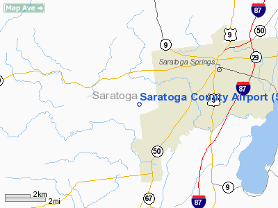
| Saratoga County Airport |
| IATA: none – ICAO: none – FAA LID: 5B2 |
| Summary |
| Airport type |
Public |
| Owner |
County of Saratoga |
| Serves |
Saratoga Springs, New York |
| Elevation AMSL |
433 ft / 132 m |
| Coordinates |
43°03′04″N 073°51′40″W / 43.05111°N 73.86111°W / 43.05111; -73.86111 |
| Runways |
| Direction |
Length |
Surface |
| ft |
m |
| 5/23 |
4,700 |
1,433 |
Asphalt/Concrete |
| 14/32 |
4,000 |
1,219 |
Asphalt/Concrete |
| Statistics (2005) |
| Aircraft operations |
38,550 |
| Based aircraft |
69 |
| Source: Federal Aviation Administration |
Saratoga County Airport (FAA LID: 5B2) is a county-owned public-use airport located three miles (5 km) southwest of the central business district of Saratoga Springs, a city in Saratoga County, New York, United States. This general aviation airport serves the city of Saratoga Springs and surrounding areas. Facilities and aircraft
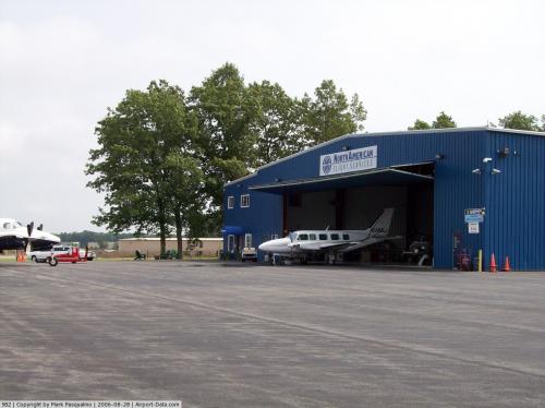
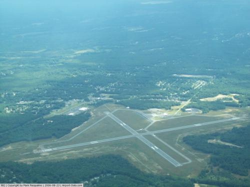
Saratoga County Airport covers an area of 300 acres (121 ha) which contains four runways: 5/23 measuring 4,700 x 100 ft (1,433 x 30 m) and 14/32 measuring 4,000 x 100 ft (1,219 x 30 m). Jet aircraft use runways 5 or 23.
For the 12-month period ending August 28, 2008, the airport had 38,700 aircraft operations, an average of 106 per day: 57% local general aviation, 39% transient general aviation, 4% air taxi and <1% military. At that time there were 54 aircraft based at this airport: 34 single-engine, 3 multi-engine, 16 gliders and 1 jet.
Nearby airports
W57 - Round Lake Airport and Seaplane Base (8.3 nm SE)
KSCH - Schenectady County Airport (12 nm S)
K27 - Burello-Mechanicville Airport (12.7 nm SE)
KALB - Albany International Airport (18 nm S)
KGFL - Floyd Bennett Memorial Airport (20 nm NE)
Source: AirNav
The above content comes from Wikipedia and is published under free licenses – click here to read more.
 |
(Click on the photo to enlarge) |
 |
(Click on the photo to enlarge) |
Location & QuickFacts
| FAA Information Effective: | 2008-09-25 |
| Airport Identifier: | 5B2 |
| Airport Status: | Operational |
| Longitude/Latitude: | 073-51-41.8000W/43-03-02.5886N
-73.861611/43.050719 (Estimated) |
| Elevation: | 434 ft / 132.28 m (Surveyed) |
| Land: | 300 acres |
| From nearest city: | 3 nautical miles SW of Saratoga Springs, NY |
| Location: | Saratoga County, NY |
| Magnetic Variation: | 14W (1995) |
Owner & Manager
| Ownership: | Publicly owned |
| Owner: | Saratoga County |
| Address: | 3654 Galway Rd
Ballston Spa, NY 12020 |
| Manager: | Joyce Richards |
| Address: | 410 Greenfield Avenue
Ballston Spa, NY 12020 |
| Phone number: | 518-885-5354 |
Airport Operations and Facilities
| Airport Use: | Open to public |
| Wind indicator: | Yes |
| Segmented Circle: | No |
| Control Tower: | No |
| Lighting Schedule: | DUSK-DAWN
ACTVT MIRL RY 05/23, VASI RY 23, REIL RY 23, & TWY LGTS - CTAF. |
| Beacon Color: | Clear-Green (lighted land airport) |
| Landing fee charge: | No |
| Sectional chart: | New York |
| Region: | AEA - Eastern |
| Traffic Pattern Alt: | 767 ft |
| Boundary ARTCC: | ZBW - Boston |
| Tie-in FSS: | BTV - Burlington |
| FSS on Airport: | No |
| FSS Toll Free: | 1-800-WX-BRIEF |
| NOTAMs Facility: | 5B2 (NOTAM-d service avaliable) |
| Federal Agreements: | NGY3 |
Airport Communications
| CTAF: | 122.800 |
| Unicom: | 122.800 |
Airport Services
| Fuel available: | 100LLA |
| Airframe Repair: | MAJOR |
| Power Plant Repair: | MAJOR |
| Bottled Oxygen: | LOW |
| Bulk Oxygen: | NONE |
Runway Information
Runway 05/23
| Dimension: | 4700 x 100 ft / 1432.6 x 30.5 m |
| Surface: | ASPH-CONC, Good Condition |
| Surface Treatment: | Saw-cut or plastic Grooved |
| Weight Limit: | Single wheel: 30000 lbs. |
| Edge Lights: | Medium |
| |
Runway 05 |
Runway 23 |
| Longitude: | 073-52-02.5083W | 073-51-23.0977W |
| Latitude: | 43-02-43.5386N | 43-03-19.8576N |
| Elevation: | 434.00 ft | 427.00 ft |
| Alignment: | 39 | 127 |
| Traffic Pattern: | Left | Left |
| Markings: | Non-precision instrument, Good Condition | Non-precision instrument, Good Condition |
| Crossing Height: | 47.00 ft | 45.00 ft |
| VASI: | 4-box on left side | 4-box on left side |
| Visual Glide Angle: | 3.00° | 3.00° |
| Runway End Identifier: | Yes | Yes |
| Centerline Lights: | No | No |
| Obstruction: | 97 ft trees, 1166.0 ft from runway, 9:1 slope to clear | 65 ft trees, 1535.0 ft from runway, 20:1 slope to clear |
|
Runway 14/32
| Dimension: | 4000 x 100 ft / 1219.2 x 30.5 m |
| Surface: | ASPH-CONC, Good Condition |
| Weight Limit: | Single wheel: 30000 lbs. |
| Edge Lights: | Medium |
| |
Runway 14 |
Runway 32 |
| Longitude: | 073-52-01.7923W | 073-51-19.6466W |
| Latitude: | 43-03-15.9384N | 43-02-51.3313N |
| Elevation: | 432.00 ft | 426.00 ft |
| Alignment: | 127 | 127 |
| Traffic Pattern: | Left | Left |
| Markings: | Basic, Good Condition | Basic, Good Condition |
| Crossing Height: | 0.00 ft | 46.00 ft |
| VASI: | | 4-box on left side
VASI CLNC PLANE OBSTN EXISTS ON RY 32 DUE TO TREE HEIGHT. |
| Visual Glide Angle: | 0.00° | 3.00° |
| Runway End Identifier: | | Yes |
| Centerline Lights: | No | No |
| Obstruction: | 69 ft trees, 545.0 ft from runway, 255 ft left of centerline, 5:1 slope to clear | 71 ft trees, 827.0 ft from runway, 8:1 slope to clear |
|
Radio Navigation Aids
| ID |
Type |
Name |
Ch |
Freq |
Var |
Dist |
| PSF | FAN MARKER | Abyss | | | 13W | 45.8 nm |
| HEU | NDB | Hunter | | 356.00 | 14W | 12.3 nm |
| JJH | NDB | Johnstown | | 523.00 | 14W | 20.9 nm |
| VWD | NDB | Mount Snow | | 224.00 | 15W | 44.5 nm |
| DXT | NDB | Dalton | | 370.00 | 15W | 46.3 nm |
| PFH | NDB | Philmont | | 272.00 | 13W | 48.3 nm |
| CAM | VOR/DME | Cambridge | 097X | 115.00 | 14W | 23.0 nm |
| RUT | VOR/DME | Rutland | 47X | 111.00 | 15W | 49.1 nm |
| ALB | VORTAC | Albany | 100X | 115.30 | 13W | 18.4 nm |
| GFL | VORTAC | Glens Falls | 039X | 110.20 | 14W | 20.6 nm |
| ALB | VOT | Albany County | | 108.20 | | 18.6 nm |
Remarks
- JET OR TURBINE ACFT USE 5 OR 23.
- GLIDER ACTVTY ON WKENDS & OCNLY WKDAYS WITH EXTENSIVE PRE-LAUNCH & AFTER LDG GND OPNS ON SHOULDERS OF RY IN USE.
- ALBANY ANG HELS DO TGL OPNS USUALLY DURG DALGT HRS.
- YEAR ROUND FEDERALLY & STATE PROTECTED HABITAT FOR KARNER BLUE BUTTERFLY; UNAUTHORIZED OFF-PAVEMENT OPNS PROHIBITED.
- GCO AVBL ON FREQ 118.125 THRU ALB CLEARANCE DELIVERY.
- UNKNOWN.
Images and information placed above are from
http://www.airport-data.com/airport/5B2/
We thank them for the data!
| General Info
|
| Country |
United States
|
| State |
NEW YORK
|
| FAA ID |
5B2
|
| Latitude |
43-03-04.540N
|
| Longitude |
073-51-40.300W
|
| Elevation |
433 feet
|
| Near City |
SARATOGA SPRINGS
|
We don't guarantee the information is fresh and accurate. The data may
be wrong or outdated.
For more up-to-date information please refer to other sources.
|
|


