 |
|
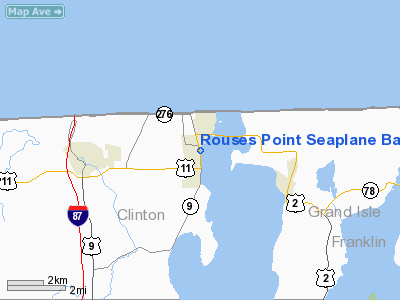
Rouses Point Seaplane Base Airport |
Location & QuickFacts
| FAA Information Effective: | 2008-09-25 |
| Airport Identifier: | K21 |
| Airport Status: | Operational |
| Longitude/Latitude: | 073-21-48.4800W/44-59-30.1400N
-73.363467/44.991706 (Estimated) |
| Elevation: | 95 ft / 28.96 m (Estimated) |
| Land: | 0 acres |
| From nearest city: | 0 nautical miles E of Rouses Point, NY |
| Location: | Clinton County, NY |
| Magnetic Variation: | 16W (1985) |
Owner & Manager
| Ownership: | Publicly owned |
| Owner: | Gaines Marina |
| Address: | 141 Lake Street
Rouses Point, NY 12979 |
| Phone number: | 518-297-7000 |
| Manager: | Dennis Richards, Gaines Marina
U.S. CUSTOMS AREA PORT DIRECTOR. |
| Address: | 141 Lake Street
Rouses Point, NY 12979 |
| Phone number: | 518-297-7000
US IMMIG & NATURALIZATION SERVICE. |
Airport Operations and Facilities
| Airport Use: | Open to public |
| Wind indicator: | No |
| Segmented Circle: | No |
| Control Tower: | No |
| Landing fee charge: | No |
| Sectional chart: | Montreal |
| Region: | AEA - Eastern |
| Boundary ARTCC: | ZBW - Boston |
| Tie-in FSS: | BTV - Burlington |
| FSS on Airport: | No |
| FSS Toll Free: | 1-800-WX-BRIEF |
| NOTAMs Facility: | BTV (NOTAM-d service avaliable) |
Airport Communications
Airport Services
| Fuel available: | MOGAS
MARINE 93 OCTANE AVAILABLE ONLY |
| Airframe Repair: | NONE |
| Power Plant Repair: | NONE |
Runway Information
Runway ALL/WAY
| Dimension: | 7900 x 500 ft / 2407.9 x 152.4 m |
| Surface: | WATER, |
| |
Runway ALL |
Runway WAY |
| Traffic Pattern: | Left | Left |
|
Radio Navigation Aids
| ID |
Type |
Name |
Ch |
Freq |
Var |
Dist |
| JL | NDB | Cote St Luc | | 370.00 | 16W | 31.1 nm |
| U | NDB | Uniform | | 201.00 | 15W | 32.8 nm |
| NDB | Mike | | 348.00 | 15W | 34.3 nm |
| H | NDB | Hotel | | 407.00 | 16W | 34.4 nm |
| UL | NDB | Montreal | | 248.00 | 16W | 34.8 nm |
| L | NDB | Lima | | 284.00 | 16W | 35.4 nm |
| JRV | NDB | Morrisville/stowe | | 375.00 | 16W | 41.4 nm |
| VKN | NDB | Mount Mansfield | | 268.00 | 16W | 46.3 nm |
| YUL | VOR/DME | Montreal | 110X | 116.30 | 16W | 45.5 nm |
| YJN | VORTAC | St Jean | 105X | 115.80 | 16W | 16.0 nm |
| PLB | VORTAC | Plattsburgh | 116X | 116.90 | 15W | 19.6 nm |
| BTV | VORTAC | Burlington | 122X | 117.50 | 15W | 36.6 nm |
| BTV | VOT | Burlington Intl | | 109.00 | | 32.9 nm |
Remarks
- PORT OF ENTRY-ADVANCE NOTICE OF US ARRIVALS REQUIRED
- PENALTY FOR NO NOTICE ARRIVAL FROM OUTSIDE USA.
- CALL U.S. CUSTOMS PRIOR TO ARR AT 518-298-8346 OR 518-298-7904.
- CTN: EXTSV WATER CRAFT ACTVTY ON OR INVOF ARPT.
- MARINE ACTIVITY IN VCNTY SAIL BOAT MAST +40' - STORED BOAT MASTS TO 50'.
- EXISTED PRIOR TO 1959.
Images and information placed above are from
http://www.airport-data.com/airport/K21/
We thank them for the data!
| General Info
|
| Country |
United States
|
| State |
NEW YORK
|
| FAA ID |
K21
|
| Latitude |
44-59-30.140N
|
| Longitude |
073-21-48.480W
|
| Elevation |
95 feet
|
| Near City |
ROUSES POINT
|
We don't guarantee the information is fresh and accurate. The data may
be wrong or outdated.
For more up-to-date information please refer to other sources.
|
|


