 |
|
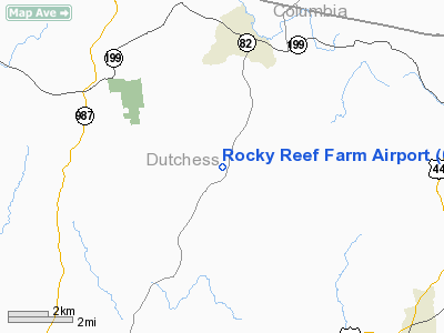
Location & QuickFacts
| FAA Information Effective: | 2008-09-25 |
| Airport Identifier: | 0NK8 |
| Airport Status: | Operational |
| Longitude/Latitude: | 073-40-13.4500W/41-55-15.3300N
-73.670403/41.920925 (Estimated) |
| Elevation: | 450 ft / 137.16 m () |
| Land: | 50 acres |
| From nearest city: | 1 nautical miles N of Attlebury, NY |
| Location: | Dutchess County, NY |
| Magnetic Variation: | 14W (1995) |
Owner & Manager
| Ownership: | Privately owned |
| Owner: | Mark Blodgett |
| Address: | Rr1, Rt82, Box 224
Stanfordville, NY 12581 |
| Phone number: | 508-927-3940 |
| Manager: | Mark Boyle |
| Address: | Rr1, Rt 82, Box 224
Stanfordville, NY 12581 |
| Phone number: | 914-868-7895 |
Airport Operations and Facilities
| Airport Use: | Private |
| Wind indicator: | Yes |
| Segmented Circle: | No |
| Control Tower: | No |
| Sectional chart: | New York |
| Region: | AEA - Eastern |
| Boundary ARTCC: | ZBW - Boston |
| Tie-in FSS: | ISP - New York |
| FSS Toll Free: | 1-800-WX-BRIEF |
Runway Information
Runway 04/22
| Dimension: | 2500 x 50 ft / 762.0 x 15.2 m |
| Surface: | TURF, |
| |
Runway 04 |
Runway 22 |
| Traffic Pattern: | Left | Left |
| Obstruction: | 20 ft bldg, 1000.0 ft from runway | 50 ft trees, 1000.0 ft from runway |
|
Radio Navigation Aids
| ID |
Type |
Name |
Ch |
Freq |
Var |
Dist |
| GBR | FAN MARKER | Sheffield | | | 13W | 18.5 nm |
| SKU | FAN MARKER | Stanwyck | | | 12W | 29.0 nm |
| PSF | FAN MARKER | Abyss | | | 13W | 38.0 nm |
| GBR | NDB | Great Barrington | | 395.00 | 14W | 19.7 nm |
| PFH | NDB | Philmont | | 272.00 | 13W | 20.1 nm |
| PO | NDB | Meier | | 403.00 | 12W | 24.6 nm |
| SKU | NDB | Stanwyck | | 261.00 | 12W | 29.0 nm |
| TBY | NDB | Waterbury | | 257.00 | 14W | 33.4 nm |
| SW | NDB | Neely | | 335.00 | 14W | 36.2 nm |
| DXT | NDB | Dalton | | 370.00 | 15W | 39.9 nm |
| MMK | NDB | Meriden | | 238.00 | 14W | 45.1 nm |
| HF | NDB | Lomis | | 244.00 | 15W | 49.9 nm |
| PWL | VOR/DME | Pawling | 090X | 114.30 | 12W | 9.6 nm |
| IGN | VOR/DME | Kingston | 123X | 117.60 | 12W | 16.8 nm |
| CMK | VOR/DME | Carmel | 113X | 116.60 | 12W | 38.7 nm |
| CTR | VOR/DME | Chester | 098X | 115.10 | 13W | 39.1 nm |
| BDL | VORTAC | Bradley | 027X | 109.00 | 14W | 43.9 nm |
| BAF | VORTAC | Barnes | 077X | 113.00 | 14W | 45.0 nm |
| BDL | VOT | Bradley Intl | | 111.40 | | 44.2 nm |
| HFD | VOT | Hartford | | 108.20 | | 47.0 nm |
| ALB | VOT | Albany County | | 108.20 | | 49.8 nm |
Remarks
- PRVDD DAYTIME VFR OPNS ONLY, NO ACFT OVER 12,500 LBS, 20:1 APCH SLOPE, LDG AREA GRADED, TREES N & S OF RY REMOVED OR TOPPED.
Images and information placed above are from
http://www.airport-data.com/airport/0NK8/
We thank them for the data!
| General Info
|
| Country |
United States
|
| State |
NEW YORK
|
| FAA ID |
0NK8
|
| Latitude |
41-55-15.330N
|
| Longitude |
073-40-13.450W
|
| Elevation |
450 feet
|
| Near City |
ATTLEBURY
|
We don't guarantee the information is fresh and accurate. The data may
be wrong or outdated.
For more up-to-date information please refer to other sources.
|
|


